
Southington is a town in Hartford County, Connecticut, United States. As of the 2020 United States Census, it had a population of 43,501. Southington contains the villages of Marion, Milldale, and Plantsville.

Ansonia is a city in New Haven County, Connecticut, on the Naugatuck River, immediately north of Derby, and about 12 miles (19 km) northwest of New Haven. The population was 18,918 at the time of the 2020 census. The ZIP code for Ansonia is 06401. The city is served by the Metro-North Railroad. Ansonia Station is a stop on the railroad passenger commuter service's Waterbury Branch connecting to New York's Grand Central Terminal. Ansonia also is served by the Connecticut Transit bus carrier. Connecticut Route 8 serves Ansonia.

Waterbury is a city in the U.S. state of Connecticut on the Naugatuck River, 33 miles (53 km) southwest of Hartford and 77 miles (124 km) northeast of New York City. Waterbury is the second-largest city in New Haven County, Connecticut. According to the 2020 US Census, in 2020 Waterbury had a population of 114,403. As of the 2010 census, Waterbury had a population of 110,366, making it the 10th largest city in the New York Metropolitan Area, 9th largest city in New England and the 5th largest city in Connecticut.
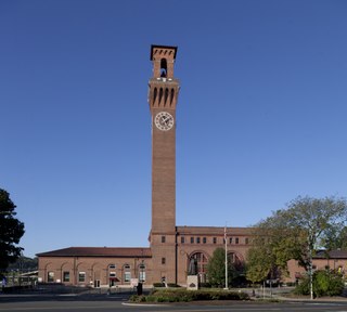
The Waterbury Union Station building is located on Meadow Street in the city of Waterbury, Connecticut, United States. It is a brick building dating to the first decade of the 20th century. Its tall clock tower, built by the Seth Thomas Company, is the city's most prominent landmark.
The neighborhoods of Hartford, Connecticut in the United States are varied and historic.
The Central or Midtown section of Norwalk, Connecticut is an urbanized area in roughly the geographic center of the city, north of the South Norwalk neighborhood and the Connecticut Turnpike. Wall Street, West Avenue and Belden Avenue are the main thoroughfares. It has also been called "Norwalk Center" or "Downtown Norwalk".
Naugatuck Valley Community College (NVCC) is a public community college in Waterbury, Connecticut. It is one of the 13 colleges in the Connecticut State Colleges & Universities system. NVCC grants a variety of associate degrees and certificates.

Several neighborhoods of Norwich, Connecticut maintain independent identities and are recognized by official signs marking their boundaries. The following is a list of neighborhoods in Norwich.
Waterville is a neighborhood of the city of Waterbury, Connecticut. It was formerly known as Pine Hole and Haydensville. It has been home to industrial and manufacturing facilities from the 1960s onward. The ethnic makeup of Waterville consists of Italian, Irish, French and Latin American. This section of Waterbury contains two parks and the main office of the city's Department of Transportation.
Town Plot is a neighborhood in the west end of the city of Waterbury, Connecticut.

Little Italy is a neighborhood located in the North End of Bridgeport, Connecticut on Madison Avenue, near the Fairfield County Correctional Facility and Central High School, with a high Italian-American population.

St. Stanislaus Kostka Parish is a former parish in Waterbury, Connecticut, United States, originally designated for Polish immigrants.

The Downtown Waterbury Historic District is the core of the city of Waterbury, Connecticut, United States. It is a roughly rectangular area centered on West Main Street and Waterbury Green, the remnant of the original town commons, which has been called "one of the most attractive downtown parks in New England."

The Bank Street Historic District is a group of four attached brick commercial buildings in different architectural styles on that street in Waterbury, Connecticut, United States. They were built over a 20-year period around the end of the 19th century, when Waterbury was a prosperous, growing industrial center. In 1983 they were recognized as a historic district and listed on the National Register of Historic Places.

Notre Dame de Lourdes, known from 2012 to 2018 as St. Bernadette Parish, is a former Roman Catholic parish in Fall River, Massachusetts. A part of the Roman Catholic Diocese of Fall River, the parish was established in 1874 to serve the growing French-Canadian population located in the city's Flint Village section. Since its founding, the parish has occupied three different church buildings; a wooden structure (1874–1893), a spectacular granite church (1906–1982) and the current modern church (1986-2018). The parish complex over time has also consisted of other multiple buildings, including St. Joseph's Orphanage, The Jesus Marie Convent, a school, the church rectory, the Brothers' residence, and the former Msgr. Prevost High School. The parish also includes Notre Dame Cemetery, located in the city's south end.
The East End is a neighborhood in the city of Waterbury, Connecticut. It has a commercial center, schools, parks and community gatherings.
The North End is a neighborhood/section of the city of Waterbury, Connecticut. It is just north of the city's downtown district and contains its own commercial facilities, schools and municipalities. The North End is one of Waterbury's oldest neighborhoods and self-sustaining.
Brooklyn is a section/neighborhood of the city of Waterbury, Connecticut. Its name is derived from immigrants who moved up the road from Brooklyn in New York City. The area lies southwest of I-84 and west of route 8, nestled between the sections of Town Plot and the South End. At its height, Brooklyn contained five grammar schools, three drug stores, three theaters, eight bakeries, two breweries, a library, a firehouse, a YMCA, and 22 taverns.
Bunker Hill is a neighborhood of the city of Waterbury, Connecticut. Though part of the city of Waterbury, it has its own identity with its own commercial center, schools, parks and gatherings. It can be self-sustaining, containing many attributes of municipalities throughout the state. Like the other sections/neighborhoods of Waterbury, its distinctive character, shaped by the history and geography of the city, has led residents to form an unusual loyalty to their neighborhood.

Saint Anne Church, formally the Shrine of Saint Anne for Mothers, is a Roman Catholic church located in the South End neighborhood of Waterbury, CT, part of All Saints Parish. Saint Anne Parish was founded in 1886 to serve city's the French-Catholic population. For nearly 100 years, two 100 foot steeples served as a prominent Waterbury landmark; however, due to ongoing structural problems, the spires were carefully removed in 2019 and stored for possible reconstruction.
