Southern High School (Baltimore, Maryland)

Last updated
Southern High School, in its second building complex at 1100 Covington Street in Federal Hill / old South Baltimore on the eve of its conversion and renaming in early 2000s to the present Digital Harbor High School Southern1.jpg
Southern High School, in its second building complex at 1100 Covington Street in Federal Hill / old South Baltimore on the eve of its conversion and renaming in early 2000s to the present Digital Harbor High School

Southern High School was a former public secondary school on Warren Avenue between William Street to the west and Riverside Avenue to the east, in the Federal Hill neighborhood of the northern side of the larger old South Baltimore community on the Whetstone Point peninsula. With historic Fort McHenry (former Fort Whetstone dating from the American Revolutionary War) from the War of 1812 (1812-1815), to the southeast at the point itself and additional residential areas surrounding the high school in tightly packed rowhouses and streets known as Locust Point and Riverside to the south and southeast along with the restored Otterbein and Sharp-Leadenhall neighborhoods to the west, also just south of the downtown central business district and famed "Inner Harbor" of the City of Baltimore, in Maryland.

Contents

The old Southern High complex of buildings faces historic Federal Hill Park across the street to the north, overlooking the current tourist attractions of the Inner Harbor of the former industrial/commercial "Basin" of the Northwest Branch of the Patapsco River dating as a port since 1706, as Baltimore Harbor.

S.H.S. was originally built in 1910 as one of the first of a new national type of school becoming popular in American public education by the 1920s organizing grades seven, eight and nine together, then known as the "junior high school" (later reorganized, advanced earlier by a grade and known as "middle schools" for the 6th-7th-8th grades by the 1980s) and had a co-ed student body with both boys and girls for the first time in Baltimore City, which previously only had four specialized/college preparatory/citywide, sex-segregated (single sex) public high schools - with all-male: Baltimore City College (1839), Baltimore Polytechnic Institute (1883), and the all-female: Western High School (1844), Eastern High School (1844), since the beginnings of the Baltimore City Public Schools system in 1829. Also a public high school had also been established in 1883 "The Colored High School", which later became Frederick Douglass High School which at some point in its history became open to both African-American boys and girls. In addition, with also co-educational Forest Park High School later built in the early 1920s in the northwest area of the city as the first "co-ed" Baltimore public high school, these types of neighborhood/district "comprehensive" public high schools soon spread through all quadrants of the city, eventually numbering about 20 co-ed neighborhood high schools in the Baltimore City Public Schools by the early 1970s. In the surrounding rural now suburban Baltimore County to the west, north and east of the city and Anne Arundel County to the city's south, the first public high school established in the late 19th century were open to both boys and girls and eventually grew to a similar number of about 25 secondary schools in neighborhoods each in both counties to the present.

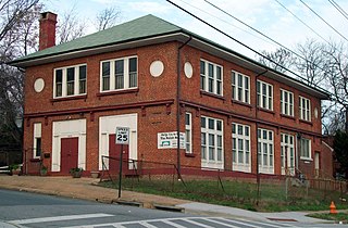
An addition/annex building to the east of the original 1910 S.H.S. structure, also facing Warren Avenue at the intersection with Riverside Avenue was constructed in 1926 of matching red brick with limestone trim and a more modernist style gym-swimming pool brick building to the south in 1956.

The new type of co-educational neighborhood public high school had a challenging new role in the Baltimore City Public Schools system. Now raised to the level of a full high school / secondary school from its previous lower "junior high" status, the building was assigned the BCPS number of #70 in the 1920s.

The Southern High School, originally located on the southeast corner of Warren Avenue and William Street, three blocks to the east from the main commercial district of the old South Baltimore commercial district neighborhood between Light Street and South Charles Street, with the adjacent municipal markethouse (one of originally eleven at their height, later seven of the city Public Market House system) of the Cross Street Market, established in the 1840s.

The Southern High building was constructed of red brick with limestone trim in a Jacobean/English Tudor style architecture used for a number of Baltimore City and other American schools of that era. Located on a 2.45-acre (9,900 m2) site adjacent to the sidewalks with rows of traditional Baltimore rowhouses with famous white marble steps and front facade bases were on the east, west and south sides of the school in the Federal Hill/South Baltimore neighborhood, but fronting towards the southern side of Federal Hill Park which overlooks the downtown skyline of the city's central business district and the former "Basin", now the famed "Inner Harbor".

The Southern High building complex at its most extensive period contained an auditorium, three gymnasiums, a 500-person capacity cafeteria, library, six shops, six home education rooms, one laboratory, and 44 classrooms. [1]

By 1955, the school had an enrollment of 1,800 students, necessitating further enlargement of the facilities. Then Mayor Thomas J. D'Alesandro, Jr., broke ground on an expansion project designed to accommodate 600 additional students. This $2 million (1956 money) addition and expansion was completed in the summer of 1956, which added eight more regular classrooms, a double classroom, five new art rooms, eight commercial classrooms for typing and business machines, three music rooms, a three shops for machine, print and auto mechanic instruction, allowing the school to thrive while the city continued to grow. [2]

Construction of replacement building, 19761978

By 1976, when the school had again outgrown its capacity, but also with declining physical conditions because of decades of suffering heavy hard usage with typical big city annual budget problems of poor and often deferred maintenance, Baltimore City Public School officials deemed it necessary to erect a new structure. The "new" Southern High School, was only two blocks to the southeast in the 1100 block of Covington Street, overlooking to the north and east of the Northwest Branch of the Patapsco River, east of the Inner Harbor towards the lower Baltimore Harbor which was still active and busy with freight, cargo and shipping facilities. The new S.H.S. looked down a two block slope towards the Francis Scott Key Highway of 1913 ("Key Highway") and the shipyards from the Bethlehem Steel Corporation from Bethlehem, Pennsylvania bordering it on the north side waterfront facing the Patapsco River's Northwest Branch. Upon its completion in late 1978, the new modernist simple stark block building of light tan/brown brick was capable of accommodating 2,400 students. The State of Maryland's School Construction Program provided $11.7 million for the project of the estimated total cost of $17 million. [3] [4]

Transition to Digital Harbor High School, 20022005

The Covington Street structure still remains but the high school changed names and academic focus in 2002, being renamed and becoming the current Digital Harbor High School. [5] The last class of Southern High School graduated in 2005. [6]

Notable alumni

The original Southern High School building was renovated and reopened in September, 1983 as a condominium and apartment complex. [7] One of its most famous alumni, Hall of Fame baseball player Al Kaline, graduated from Southern High School in 1953 and began playing that summer as an 18-year-old in the Major Leagues for the Detroit Tigers. [8] Other notable alumni include professional wrestler Brian "Axl Rotten" Knighton. [9]

Related Research Articles

Baltimore City Community College (BCCC) is a public community college in Baltimore, Maryland. It is the only community college in the city and the only state-sponsored community college in the state. It is accredited by the Middle States Commission on Higher Education (MSCHE). It was founded in 1947 and has about 5,000 students enrolled in one of its campuses.

<span class="mw-page-title-main">Fell's Point, Baltimore</span> Neighborhood of Baltimore in Maryland, United States

Fell's Point is a historic waterfront neighborhood in southeastern Baltimore, Maryland. It was established around 1763 along the north shore of the Baltimore Harbor and the Northwest Branch of the Patapsco River. The area has many antique, music, and other stores, restaurants, coffee bars, a municipal markethouse with individual stalls, and over 120 pubs. Located 1.5 miles east of Baltimore's downtown central business district and the Jones Falls stream, Fells Point has a maritime past and the air of a seafaring town.

<span class="mw-page-title-main">Federal Hill, Baltimore</span> Neighborhood of Baltimore in Maryland, United States

Federal Hill is a neighborhood in Baltimore, Maryland, that lies just to the south of the city's central business district. Many of the structures are included in the Federal Hill Historic District, listed on the National Register of Historic Places in 1970. Other structures are included in the Federal Hill South Historic District, listed in 2003.

<span class="mw-page-title-main">Cherry Hill, Baltimore</span> Neighborhood of Baltimore in Maryland, United States

Cherry Hill is one of the southernmost neighborhoods in Baltimore, Maryland.

<span class="mw-page-title-main">Power Plant Live!</span> Collection of businesses in the Inner Harbor section of Baltimore, Maryland, US

Power Plant Live! is a collection of bars, restaurants and other businesses in the Inner Harbor section of downtown Baltimore, Maryland. It was developed by The Cordish Companies and opened in phases during 2001, 2002, and 2003. The entertainment complex gets its name from the nearby "Power Plant" building, three blocks south on municipal Pier 4 on East Pratt Street facing the Inner Harbor, which was also later re-developed by Cordish.

<span class="mw-page-title-main">Mondawmin, Baltimore</span> Neighborhood of Baltimore in Maryland, United States

Mondawmin is a neighborhood located in the Western district of Baltimore, Maryland, United States. The neighborhood is surrounded by Druid Hill Park, the Whitelock Community, and Lower Park Heights. Included within its boundaries are Frederick Douglass High School, and Mondawmin Mall. The Baltimore Metro Subway serves the neighborhood, with a station at Mondawmin Mall that is also a hub for many bus routes.

<span class="mw-page-title-main">Curtis Bay, Baltimore</span> Neighborhood of Baltimore in Maryland, United States

Curtis Bay is a residential / commercial / industrial neighborhood in the southern portion of the City of Baltimore, Maryland, United States.

<span class="mw-page-title-main">Union Square, Baltimore</span> United States historic place

Union Square is a neighborhood located in the Sowebo area of Baltimore. It dates to the 1830s and includes a historic district of houses and commerce buildings.

<span class="mw-page-title-main">Charles Street (Baltimore)</span> State Highway in Maryland, US

Charles Street, known for most of its route as Maryland Route 139, runs through Baltimore and the Towson area of Baltimore County. On the north end, it terminates at an intersection with Bellona Avenue near Interstate 695 (I-695). At the south end, it terminates in Federal Hill in Baltimore. Charles Street is one of the major routes through Baltimore, and is a major public transportation corridor. For the one-way portions of Charles Street, the street is functionally complemented by the parallel St. Paul Street, including St. Paul Place and Preston Gardens, Maryland Avenue, Cathedral Street, and Liberty Street.

<span class="mw-page-title-main">Westport, Baltimore</span> Neighborhood of Baltimore in Maryland, United States

Westport is a neighborhood in south Baltimore, Maryland. Westport is a majority African-American neighborhood that has struggled with crime, housing abandonment, and unemployment in the past decade. The neighborhood is bordered by the Middle Branch of the Patapsco River on the east, the city neighborhoods of Cherry Hill, Brooklyn and the southwestern Baltimore County community of Lansdowne to the southwest, Hollins Ferry Road and the Mount Winans and Lakeland neighborhoods to the west, and Interstate 95 to the north, along with the South Baltimore communities of Federal Hill and Otterbein. The Baltimore–Washington Parkway runs through the middle of Westport and intersects with Interstate 95, the main East Coast super-highway, north to south, Maine to Florida.

<span class="mw-page-title-main">Otterbein, Baltimore</span> Neighborhood of Baltimore in Maryland, United States

Otterbein is a small neighborhood of historic rowhouses in Baltimore, Maryland, United States. Otterbein is immediately southwest of, and in close walking distance to, the Inner Harbor. The neighborhood is very compact, entirely located between Hanover Street and Sharp Street, and between Barre Street and Henrietta Street. It is in small parts of zip codes 21201 and 21230. It is named for Old Otterbein Church, located immediately north of the neighborhood.

St. Paul Street and Calvert Street are a one-way pair of streets in Downtown Baltimore and areas north. The streets, which are part of Maryland Route 2, are two of Baltimore's best-known streets in the downtown area.

<span class="mw-page-title-main">St. Peter the Apostle Church</span> Historic church in Maryland, United States

St. Peter the Apostle Church was a Roman Catholic church located within the Archdiocese of Baltimore in Baltimore, Maryland. Constructed at the northwest corner of Hollins and South Poppleton Streets and, it was often referred to as "The Mother Church of West Baltimore."

<span class="mw-page-title-main">Brooklyn, Baltimore</span> Neighborhood of Baltimore in Maryland, United States

Brooklyn is one of the southernmost neighborhoods in Baltimore, Maryland. It is located near Anne Arundel County along Governor Ritchie Highway which is also Maryland Route 2. Its main roads are South Hanover Street,, Potee Street, and East Patapsco Avenue, Sixth Street, Tenth Street, and West Bay Avenue which borders the neighboring Curtis Bay community to the east, running through Bay Brook Park, which separates the two. South Hanover Street also serves as the dividing line between east–west streets in Brooklyn, as Charles Street does not exist here.

<span class="mw-page-title-main">Otterbein Church (Baltimore, Maryland)</span> Historic church in Maryland, United States

Otterbein Church, now known as Old Otterbein United Methodist Church, is a historic United Brethren church located in Baltimore, Maryland, United States. The first "German Reformed" church was built to serve the German Reformed and some Evangelical Lutheran immigrants, and later entered the Brethren strain of German Reformed Protestantism in the later Church of the United Brethren in Christ.

<span class="mw-page-title-main">Polish Home Hall</span> United States historic place

Polish Home Hall is a historic building located in the waterfront industrial/commercial/residential and heavily ethnic community of Curtis Bay in southern Baltimore, Maryland,. Built on the southwest corner of Fairhaven Avenue and Filbert Street near the top of the commanding heights overlooking to the east the sloping streets of the neighborhood of Curtis Bay, about four city blocks wide and 15 blocks length.

<span class="mw-page-title-main">Hendler Creamery</span> United States historic place

Hendler Creamery is a historic industrial complex in Jonestown, Baltimore, Maryland. Since it spans an entire block it has addresses at 1100 E. Baltimore St. and 1107 E. Fayette St. "The Hendler Creamery is historically significant for its contribution to the broad patterns of history in three areas of significance: transportation, performing arts, and industry."

<span class="mw-page-title-main">Charles Center</span> Neighborhood of Baltimore in Maryland, United States

Charles Center is a large-scale urban redevelopment project in central Baltimore's downtown business district of the late 1950s and early 1960s. Beginning in 1954, a group called the "Committee for Downtown" promoted a master plan for arresting the commercial decline of central Baltimore. In 1955, the "Greater Baltimore Committee", headed by banker and developer James W. Rouse, joined the effort. A plan was developed by noted American urban planner and architect David A. Wallace, (1917−2004), strongly supported by Mayors Thomas L. J. D'Alesandro, Jr. (1947−1959) and Theodore R. McKeldin, and many in their administrations, which formed the basis of a $25 million bond issue voted on by the citizens of Baltimore City during the municipal elections in November 1958. The architects' view of the overall Charles Center Redevelopment Plan with the conceptions of possible buildings, lay-out and plan that was publicized to the voters that spring and summer before, only slightly resembles the actual buildings and designs that later were really constructed by the mid-1970s.

<span class="mw-page-title-main">Baltimore</span> Largest city in Maryland, U.S.

Baltimore is the most populous city in the U.S. state of Maryland. With a population of 585,708 at the 2020 census, it is the 30th-most populous city in the United States. Baltimore was designated an independent city by the Constitution of Maryland in 1851, and is currently the most populous independent city in the nation. As of the 2020 census, the population of the Baltimore metropolitan area was estimated to be 2,838,327, making it the 20th-largest metropolitan area in the country. When combined with the larger Washington metropolitan area, the Washington–Baltimore combined statistical area (CSA) has a 2020 U.S. census population of 9,973,383, the third-largest in the country.

<span class="mw-page-title-main">Patterson Park (neighborhood), Baltimore</span> United States historic place

Patterson Park is a neighborhood in Baltimore, Maryland, United States. Named for the 137-acre park that abuts its north and east sides, the neighborhood is in the southeast section of Baltimore city, roughly two miles east of Baltimore's downtown district.

References

  1. City of Baltimore Department of Education Bureau of research, School Plant Directory, by John L. Stenquist. City of Baltimore Department of Education Bureau of research, September 1, 1952.
  2. "$2-Million School Dream Nears Reality", The Baltimore Sun , July 6, 1956.
  3. Peter Buehl, "Firm of 'advocates' cuts school cost", The Baltimore Sun , Dec 12, 1976.
  4. "Southern students, merchants to reschedule summit", Baltimore News-American , November 27, 1978.
  5. Liz Bowie (2002-08-30). "Officials to delay or stagger 3 city high schools' openings ; Northern, Southern, Lake Clifton affected". The Baltimore Sun . Retrieved 2008-09-26.
  6. Michael Olesker (2005-08-26). "City school may be sign of better days for system". The Baltimore Sun . Retrieved 2008-09-26.
  7. "Old Southern is on road to becoming Battery Place" The Baltimore Sun , September 13, 1981.
  8. Official Profile, Photo and Data Book, Detroit Tigers (1957), p. 29.
  9. Eck, Kevin (June 12, 2005). "After 'Rotten' past, he returns to center stage". The Baltimore Sun . Tribune Publishing . Retrieved December 14, 2014.

39°16′37″N76°36′26″W / 39.276828°N 76.607329°W / 39.276828; -76.607329