
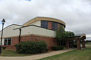
Dayton–Wright Brothers Airport is a public airport located 10 miles (16 km) south of the central business district of Dayton, Ohio, located mainly in Miami Township, Montgomery County and partly in Clearcreek Township, Warren County, near the suburb of Springboro. It is owned and operated by the City of Dayton and serves as the reliever airport for Dayton International Airport. It mainly serves corporate and personal aircraft users. The airport's identifying code, MGY, is a reference to its former name of Montgomery County Airport.
Ohio University Airport or Gordon K. Bush Airport, also known as Snyder Field, is a public-use airport located on State Route 32/U.S. 50 in the village of Albany, about ten miles (16 km) southwest of the city of Athens, in Athens County, Ohio, United States.
Wend Valley Airport is a privately-owned, public-use general aviation airport located northwest of Charlotte in Eaton County, Michigan, United States.
Portage County Airport, also known as Portage County Regional Airport, is a public use airport in Portage County, Ohio, United States. It is owned by the Portage County Board of Commissioners and located three nautical miles (6 km) north of Ravenna, in Shalersville Township. This airport is included in the National Plan of Integrated Airport Systems for 2011–2015, which categorized it as a general aviation facility.
Greater Kankakee Airport is a public use airport located three nautical miles (6 km) south of the central business district of Kankakee, a city in Kankakee County, Illinois, United States. It is included in the National Plan of Integrated Airport Systems for 2011–2015, which categorized it as a general aviation facility.
Poplar Grove Airport is a small general aviation airport located in Poplar Grove, Illinois, United States. The airport was founded in 1972 as Belvidere Airport and renamed in 1994. It is located 3 miles south of Poplar Grove, and 3 miles north of Belvidere. The airport is privately owned and open to the public.
Newark–Heath Airport is a public airport located in Heath, Ohio. It is three miles (4.8 km) southwest of the central business district of Newark, a city in Licking County, Ohio, United States. The airport was opened in 1930 by the city of Newark, and was transferred to the Licking County Regional Airport Authority in 1967. The airport currently has a McDonnell Douglas F-4C Phantom II S.N. 64–0683 on static display.

Union County Airport is a public use airport in Union County, Ohio, United States. It is owned by the Union County Airport Authority and located one nautical mile (2 km) southeast of the central business district of Marysville, Ohio. This airport is included in the National Plan of Integrated Airport Systems for 2011–2015, which categorized it as a general aviation facility.
Lorain County Regional Airport is a public airport in Lorain County, Ohio, owned by the Lorain County Board of Commissioners and located in New Russia Township. The airport is about 7 miles south of Lorain and 5 miles southwest of Elyria. The National Plan of Integrated Airport Systems for 2011–2015 categorized it as a general aviation reliever airport.

Sault Ste. Marie Municipal Airport, also known as Sanderson Field, is a city-owned, public-use airport located 1 nmi (1.9 km) southwest of the central business district of Sault Ste. Marie, a city in Chippewa County, Michigan, United States.
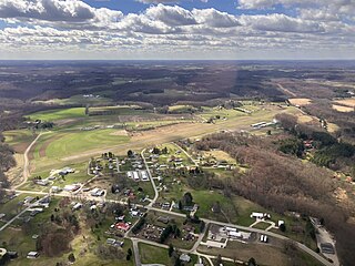
Paul C. Miller–Sparta Airport is a public airport located 3 mi (5 km) southeast of Sparta, Michigan. Established in 1941, the airport is currently owned and operated by the Village of Sparta and is self-supporting, requiring no public funding. It is included in the Federal Aviation Administration (FAA) National Plan of Integrated Airport Systems for 2017–2021, in which it is categorized as a regional general aviation facility.
Galion Municipal Airport is three miles northeast of Galion in Crawford County, Ohio. The FAA's National Plan of Integrated Airport Systems for 2009–2013 classified it as a general aviation airport.
Carroll County–Tolson Airport is a county–owned, public-use airport located one nautical mile (1.85 km) southeast of the central business district of Carrollton, a village in Carroll County, Ohio, United States. It is owned by the Carroll County Airport Authority. According to the FAA's National Plan of Integrated Airport Systems for 2009–2013, it is categorized as a general aviation airport.
Dalton Airport is a privately owned, public use airport located two nautical miles (4 km) east of the central business district of Flushing, in Genesee County, Michigan, United States. It is named after its founder, Edwin P. Dalton, who opened it in 1946 on the former site of the Marsa farm.
Harry Clever Field is a public airport three miles southeast of New Philadelphia, in Tuscarawas County, Ohio. The National Plan of Integrated Airport Systems for 2018 categorized it as a general aviation facility.
The Youngstown Elser Metro Airport is a privately owned, public use general aviation airport located 7 miles southwest of Youngstown in Beaver Township, Mahoning County, Ohio, United States. It has a 10/28 asphalt runway of 4,012 ft × 50 ft in dimension.
Holmes County Airport is a public airport located two miles southwest of Millersburg, Ohio, United States. It is owned and operated by the Holmes County Airport Authority.
The Picnkeyville/Du Quoin Airport is a civil, public use airport located 6 miles southeast of Pinckneyville and about 9 miles west of Du Quoin, Illinois, United States. The airport is publicly owned by the two cities.
Cottonwood Airport is a public use airport located two-mile (3.2 km) northwest of Rockford, Illinois. The airport is privately owned. The airport is one of multiple airports in Rockford; the city's main airport, located six miles (9.7 km) south of Cottonwood, is the Chicago/Rockford International Airport.
Ray Community Airport is a privately owned, public use airport located in Ray Township, Macomb County. Michigan. The airport sits on 93 acres of land at an elevation of 632 feet.
