Related Research Articles

This is a list of the extreme points of Ireland – the points that are farthest north, south, east or west in Ireland. It includes the Republic of Ireland and Northern Ireland.
The Forrestal Range is a largely snow-covered mountain range, about 105 km (65 mi) long, standing east of Dufek Massif and the Neptune Range in the Pensacola Mountains of Antarctica. Discovered and photographed on 13 January 1956 on a transcontinental patrol plane flight of U.S. Navy Operation Deep Freeze I from McMurdo Sound to the vicinity of the Weddell Sea and return.

James Ross Island is a large island off the southeast side and near the northeastern extremity of the Antarctic Peninsula, from which it is separated by Prince Gustav Channel. Rising to 1,630 metres (5,350 ft), it is irregularly shaped and extends 64 km in a north–south direction. It was charted in October 1903 by the Swedish Antarctic Expedition under Otto Nordenskiöld, who named it for Sir James Clark Ross, the leader of a British expedition to this area in 1842 that discovered and roughly charted a number of points along the eastern side of the island. The style, "James" Ross Island is used to avoid confusion with the more widely known Ross Island in McMurdo Sound.
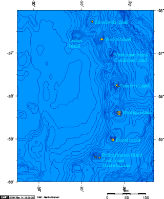
The Candlemas Islands are a group of small uninhabited islands lying at the northern part of the South Sandwich Islands, 23 miles (37 km) southeast of Visokoi Island. They consist of Candlemas Island and Vindication Island, divided by Nelson Channel, and numerous rocks.
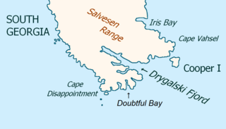
Drygalski Fjord is a bay 1 mile (1.6 km) wide which recedes northwestwards 7 miles (11 km), entered immediately north of Nattriss Head along the southeast coast of South Georgia. It was charted by the Second German Antarctic Expedition, 1911–12, under Wilhelm Filchner, and named for Professor Erich von Drygalski, the leader of the First German Antarctica Expedition, 1901–03.

Shearer Stack is a rock stack lying 1.5 miles (2.4 km) southwest of False Round Point, off the north coast of King George Island in the South Shetland Islands. Named by the United Kingdom Antarctic Place-Names Committee (UK-APC) in 1960 for the American sealing vessel Charles Shearer from Nantucket, which visited the South Shetland Islands in 1874–75. In 1877 the ship again sailed for the islands and disappeared without a trace.
Baumann Crag is a rock crag rising to 1,265 metres (4,150 ft) and forming the south end of Halfway Nunatak, Victoria Land. It was named by the Advisory Committee on Antarctic Names in 1994 after Christopher C. Baumann, United States Geological Survey (USGS) cartographer; member of the satellite surveying team at South Pole Station, winter party 1984; leader of the USGS mapping control field team on Seymour Island, summer season, 1992–93.

Mount Bransfield is a prominent conical-topped, ice-covered mountain, 760 metres (2,500 ft) high, rising 5.4 miles (9 km) east-southeast of Siffrey Point, 2 nautical miles (4 km) southwest of Cape Dubouzet and 2.7 nautical miles (5 km) north of Koerner Rock, at the northeast tip of the Antarctic Peninsula.
Nicol Crags is a rock crags rising to about 1,300 m to the south of Arkell Cirque in the Read Mountains, Shackleton Range. Photographed from the air by the U.S. Navy, 1967, and surveyed by British Antarctic Survey (BAS), 1968–71. In association with the names of geologists grouped in this area, named by the United Kingdom Antarctic Place-Names Committee (UK-APC) in 1971 after William Nicol (1770–1851), Scottish natural philosopher who devised the Nicol prism and the preparation of thin rock sections, thus contributing to the techniques of microscopy.
Jupiter Glacier is a glacier on the east coast of Alexander Island, Antarctica, 10 nautical miles (19 km) long and 5 nautical miles (9 km) wide at its mouth, which flows east into George VI Sound to the south of Ablation Valley. It was first photographed from the air on November 23, 1935, by Lincoln Ellsworth and mapped from these photos by W.L.G. Joerg. It was roughly surveyed in 1936 by the British Graham Land Expedition, and was named for the planet Jupiter by the Falkland Islands Dependencies Survey following their surveys in 1948 and 1949.

Flagstaff Glacier is a very small glacier lying immediately north of Flagstaff Hill on Keller Peninsula, King George Island, in the South Shetland Islands. The name arose locally in about 1958 and derives from association with Flagstaff Hill.
Mersey Spit is a spit on the south coast of King George Island, close north of Penguin Island, in the South Shetland Islands of Antarctica. It was charted and named during 1937 by Discovery Investigations personnel on the Discovery II.
Mount Martine is a massive mountain, about 800 metres (2,600 ft) high, with a prominent rocky north face and ice-covered south slopes, overlooking the north shore of Charcot Island, south of Cheesman Island, in the east Bellinghausen Sea of Antarctica.
Kerick Col is a col running north–south at 150 metres (500 ft) between Gin Cove and Rum Cove, in the western part of James Ross Island, Antarctica. Crisscross Crags rise at the east side of the col. In association with names in this area from Kipling's The Jungle Book, it was named by the UK Antarctic Place-Names Committee in 1983 after Kerick Booterin, chief of the seal hunters in The White Seal.
The Lachman Crags form an escarpment which extends in a north–south direction for about 5 nautical miles (9 km), its high point rising to 645 metres (2,120 ft), standing 3 nautical miles (6 km) south-southwest of Cape Lachman on James Ross Island, Antarctica. Berry Hill lies between the crags and the cape. It was surveyed by the Falkland Islands Dependencies Survey in 1945, and named after Cape Lachman.

Lister Glacier is a glacier 5 nautical miles (9 km) long and 1 nautical mile (2 km) wide, draining the northeast slopes of Stribog Mountains and flowing into Bouquet Bay just south of Duclaux Point on the northeast side of Brabant Island, in the Palmer Archipelago, Antarctica.
The Forbidden Plateau is a long, narrow plateau extending southwestward from Charlotte Bay to Flandres Bay in Graham Land. It borders Bruce Plateau on the south and Foster Plateau on the north. The feature was mapped by the Falkland Islands Dependencies Survey (FIDS) from photos taken by Hunting Aerosurveys Ltd. in 1956–57. Its name was picked by the UK Antarctic Place-names Committee (UK-APC) because all attempts to reach the plateau failed until it was finally traversed by Falkland Islands Dependencies Survey (FIDS) members in 1957.
References
![]() This article incorporates public domain material from "Splinter Crag". Geographic Names Information System . United States Geological Survey.
This article incorporates public domain material from "Splinter Crag". Geographic Names Information System . United States Geological Survey.
Capital: King Edward Point | |||||||
| General | |||||||
| Settlements / Whaling stations | |||||||
| South Georgia islands | |||||||
| South Sandwich Islands |
| ||||||
| Seamounts | |||||||
| Landmarks |
| ||||||
| | This South Georgia and the South Sandwich Islands location article is a stub. You can help Wikipedia by expanding it. |