Related Research Articles

Perry County is a county in the U.S. state of Kentucky. As of the 2020 census, the population was 28,473. Its county seat is Hazard. The county was founded in 1820. Both the county and county seat are named for Commodore Oliver Hazard Perry, a naval hero in the War of 1812.

Manchester is a home rule-class city in Clay County, Kentucky, in the United States. It is the seat of its county and the home of a minimum- and medium-security federal prison. The city's population was 1,255 at the 2010 census.
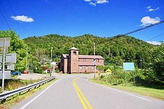
Buckhorn is a home rule-class city in Perry County, Kentucky, in the United States. The population was 162 at the 2010 census. It is centered on the Buckhorn Presbyterian Church, a log structure listed on the National Register of Historic Places. The Buckhorn Children's Center and Buckhorn Lake State Resort Park are also located here.
South Fork Kentucky River is a river in Kentucky in the United States. It is a fork of the Kentucky River that it joins just downstream of Beattyville. It is approximately 30 mi long.
The Battle of Salyersville, also called Battle of Half Mountain was the largest of the many skirmishes in Magoffin County, Kentucky, during the American Civil War.
The Red Bird River is one of two tributaries at the head of the South Fork Kentucky River, the other being the Goose Creek. It is located in the Daniel Boone National Forest, in the southeast of the U.S. state of Kentucky. It is 34.3 miles (55.2 km) long and drains the eastern half of Clay County.
Williba is an unincorporated community in Lee County, Kentucky, United States, located on Fraley Creek, one-half mile from the confluence of the North Fork and the Kentucky River.
Laurel Creek is a creek that is a tributary of Goose Creek river in Clay County, Kentucky. It is 7.5 miles (12.1 km) long. The name comes from the proliferation of mountain laurel on its riverbanks.
Turkey is an unincorporated community in Breathitt County, Kentucky. It is located on Kentucky Route 30, between the communities of Lerose and Shoulderblade.

Lotts Creek is a creek in Perry County and Knott County, Kentucky in the United States. It is a tributary of the North Fork Kentucky River that joins it at Darfork 3 miles (4.8 km) downstream of Hazard at an altitude of 820 feet (250 m). It is 8.5 miles (13.7 km) long from its mouth to where it splits into the Young's and Kelly Forks.
Beefhide is an unincorporated community spanning across a county line between Letcher County and Pike County, Kentucky, United States.
Horse Creek is a creek a tributary of Goose Creek river in Clay County, Kentucky. It is 1.5 miles (2.4 km) upstream of Manchester on Goose at an altitude of 800 feet (240 m).
Sexton's Creek is a creek in Clay County, Kentucky that is a tributary of the South Fork Kentucky River in neighbouring Owsley County, Kentucky. It is 24 miles (39 km) long.
Trace Fork or Trace Branch is a creek in Perry County, Kentucky in the United States. It a fork of Lotts Creek 1 mile (1.6 km) upstream from the latter's mouth at an altitude of 825 feet (251 m).
Big Creek is a 4.5 miles (7.2 km) long creek in Kentucky, United States whose headwaters are in Leslie County and that flows into the Red Bird River in Clay County. A postoffice and village are named for it. Its own name is likely purely descriptive of its frequent flooding and high water levels, as it is not otherwise one of the biggest tributaries of Red Bird River.
Stinking Creek is a stream in Knox County, Kentucky, in the United States.
Clear Creek Springs is an unincorporated community in Bell County, Kentucky, United States. It is named after Clear Creek.
Collins Creek, also known as Collins Fork, is a creek that is a fork of Goose Creek in Knox County and Clay County, Kentucky. It is 19 miles (31 km) long; is named for its first settler James Collins, a salt maker and hunter; joins Goose just south of Garrard; and is paralleled by road and railway for most of its course.
Beech Creek is a tributary of Goose Creek in Clay County, Kentucky. It is just under 6 miles (9.7 km) long and joins the Goose approximately 1⁄2 mile (0.80 km) below the mouth of Laurel Creek.
Lost Creek is a creek that is mainly in Breathitt County, Kentucky in the United States. It a tributary of the Troublesome Creek tributary of the North Fork Kentucky River that it joins over the county line in Perry County slightly more than 1 mile (1.6 km) upstream of the mouth of Troublesome, at an altitude of 810 feet (250 m). It is 10 miles (16 km) long. The junction of Kentucky Route 476 with Kentucky Route 15 about 6 miles (9.7 km) south-southeast of Jackson is nearby.
References
- ↑ U.S. Geological Survey Geographic Names Information System: Squabble Creek
- ↑ Campbell, Olive Dame (2012). Appalachian Travels: The Diary of Olive Dame Campbell. University Press of Kentucky. p. 106. ISBN 978-0-8131-3644-8.
Municipalities and communities of Perry County, Kentucky, United States | ||
|---|---|---|
| Cities |  | |
| CDPs | ||
| Other unincorporated communities |
| |
| Ghost town | ||
| Former mining towns | ||
| Post offices (and the creeks they are on) |
| |
37°20′45″N83°28′09″W / 37.345924°N 83.469074°W
| | This Perry County, Kentucky state location article is a stub. You can help Wikipedia by expanding it. |