Letcher County is a county located in the U.S. state of Kentucky. As of the 2020 census, the population was 21,548. Its county seat is Whitesburg. It was created in 1842 from Harlan and Perry counties, and named for Robert P. Letcher, Governor of Kentucky from 1840 to 1844.
Lee County is a county located in the U.S. state of Kentucky. As of the 2020 census, the population was 7,395. Its county seat is Beattyville. The county was formed in 1870 from parts of Breathitt, Estill, Owsley and Wolfe counties. The county was named for Robert E. Lee. The area of Kentucky where Lee County is located was a pro-union region of Kentucky but the legislature that created the county was controlled by former Confederates. The town of Proctor, named for the Rev. Joseph Proctor, was the first county seat. The first court was held on April 25, 1870, in the old Howerton House. The local economy at the time included coal mining, salt gathering, timber operations, and various commercial operations. It had a U.S. post office from 1843 until 1918.

Johnson County is a county located in the U.S. state of Kentucky. As of the 2020 census, the population was 22,680. Its county seat is Paintsville. The county was formed in 1843 and named for Richard Mentor Johnson, a colonel of the War of 1812, United States Representative, Senator, and Vice President of the United States.

Harlan County is a county located in southeastern Kentucky. As of the 2020 census, the population was 26,831. Its county seat is Harlan. It is classified as a moist county—a county in which alcohol sales are prohibited, but containing a "wet" city, in this case Cumberland, where package alcohol sales are allowed. In the city of Harlan, restaurants seating 100+ may serve alcoholic beverages.

Pineville is a home rule-class city in Bell County, Kentucky, United States. It is the seat of its county. The population was 1,732 as of the 2010 census. It is located on a small strip of land between the Cumberland River and Pine Mountain.

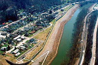
Irvine is a home rule-class city in Estill County, Kentucky, in the United States. It is the seat of its county. Its population was 2,715 at the time of the 2010 census.

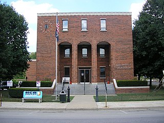
Harlan is a home rule-class city in and the county seat of Harlan County, Kentucky, United States. The population was 1,745 at the 2010 census, down from 2,081 at the 2000 census.

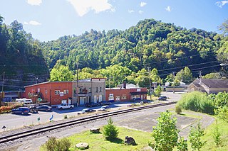
Lynch is a home rule-class city in Harlan County, Kentucky, United States. In the 2020 census the city population was 658, down from 747 in 2010.

Blackey is an unincorporated community in Letcher County, Kentucky, in the United States. As of the 2010 census, the population was 120. It is located near the early settlement of Indian Bottom. Blackey is thought to have been named after Blackey Brown, one of its citizens.

Fleming-Neon also known as Neon, is a home rule-class city in Letcher County, Kentucky, in the United States. The population was 770 at the 2010 census, down from 840 at the 2000 census.

Jenkins is a home rule-class city in Letcher County, Kentucky, United States. The population was 2,203 as of the 2010 census.

Hazard is a home rule-class city in, and the county seat of, Perry County, Kentucky, United States. The population was 5,263 at the 2020 Census.
Vicco is a Kentucky defunct city in Perry and Knott counties, Kentucky, United States as defined by Kentucky Act Acts Ch. 25. The population was 334 at the 2010 census.

St. Charles is a town in Lee County, Virginia, United States. The population was 128 at the 2010 census, down from 159 at the 2000 census.
Jonancy is a small unincorporated community and coal town in Pike County, Kentucky, United States, in the far eastern part of the state. The latitude and longitude are 37.316N and -82.583W. Jonancy is in the Eastern Coal Field region. The community is in the Eastern time zone.

The Eastern Kentucky Coalfield is part of the Central Appalachian bituminous coalfield, including all or parts of 30 Kentucky counties and adjoining areas in Ohio, West Virginia, Virginia, and Tennessee. It covers an area from the Allegheny Mountains in the east across the Cumberland Plateau to the Pottsville Escarpment in the west. The region is known for its coal mining; most family farms in the region have disappeared since the introduction of surface mining in the 1940s and 1950s.
Drift, Kentucky is an unincorporated community and coal town in Floyd County, Kentucky, United States. As of the census of 2000, there were 569 people living in the ZIP Code Tabulation Area (ZCTA) for Drift's ZIP code (41619).

Cromona is a small unincorporated community located in the mountains of Eastern Kentucky in Letcher County, Kentucky, United States. The Cromona post office has operated since 1916. Cromona is actually known as Haymond by the local residents. However, for reasons that are obscure, the post office was given a different name, Cromona. It was built as a coal town in 1916, and was named for the president of the Elk Horn Coal Corporation, Thomas S. Haymond. The population of Haymond was 502 as of the 2010 census.
Roundhill is an unincorporated community in Butler County, Kentucky, United States, situated on Butler County's eastern boundary with Edmonson County.