
Elliott County is a county located in the U.S. state of Kentucky. As of the 2010 census, the population was 7,852. Its county seat is Sandy Hook. The county was formed in 1869 from parts of Morgan, Lawrence, and Carter counties, and is named for John Milton Elliott, U.S. Congressman; Confederate Justice of the Kentucky Court of Appeals. In regard to alcohol sales, Elliott County is a dry county, meaning the sale of alcoholic beverages is prohibited everywhere in the county.

Breathitt County is a county located in the eastern Appalachian portion of the U.S. state of Kentucky. As of the 2010 census, the population was 13,878. Its county seat is Jackson, Kentucky. The county was formed in 1839 and was named for John Breathitt, who was Governor of Kentucky from 1832 to 1834. Breathitt County was a prohibition or dry county, until a public vote in July 2016 that allowed alcohol sales.

Harlan is a home rule-class city in and the county seat of Harlan County, Kentucky, United States. The population was 1,745 at the 2010 census, down from 2,081 at the 2000 census.
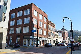
Pikeville is a city in and the county seat of Pike County, Kentucky, United States. During the 2010 U.S. Census, the population within Pikeville's city limits was 6,903. In Kentucky's current city classification system, Pikeville is a home rule-class city, a category that includes all of the state's more than 400 cities except for the two largest, Louisville and Lexington.

The Cumberland River is a major waterway of the Southern United States. The 688-mile-long (1,107 km) river drains almost 18,000 square miles (47,000 km2) of southern Kentucky and north-central Tennessee. The river flows generally west from a source in the Appalachian Mountains to its confluence with the Ohio River near Paducah, Kentucky, and the mouth of the Tennessee River. Major tributaries include the Obey, Caney Fork, Stones, and Red rivers.

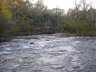
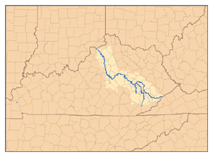
The Kentucky River is a tributary of the Ohio River, 260 miles (418 km) long, in the U.S. Commonwealth of Kentucky. The river and its tributaries drain much of the central region of the state, with its upper course passing through the coal-mining regions of the Cumberland Mountains, and its lower course passing through the Bluegrass region in the north central part of the state. Its watershed encompasses about 7,000 square miles (18,000 km2). It supplies drinking water to about one-sixth of the population of the Commonwealth of Kentucky.

The Battle of Middle Creek was an engagement fought January 10, 1862, in Eastern Kentucky during the American Civil War.

The Big South Fork National River and Recreation Area preserves the Big South Fork of the Cumberland River and its tributaries in northeastern Tennessee and southeastern Kentucky. In addition, the former mining community of Blue Heron is preserved and interpreted via signage.

Breaks Interstate Park is a bi-state state park located partly in southeastern Kentucky and mostly in southwestern Virginia, in the Jefferson National Forest, at the northeastern terminus of Pine Mountain. Rather than their respective state park systems, it is instead administered by an interstate compact between the states of Virginia and Kentucky. It is one of several interstate parks in the United States, but only one of two operated jointly under a compact rather than as two separate state park units. The Virginia Department of Conservation and Recreation and the Kentucky Department of Parks are still major partner organizations, however.
Beargrass Creek is the name given to several forks of a creek in Jefferson County, Kentucky. The Beargrass Creek watershed is the largest in the county, draining over 60 square miles (160 km2).

Buckhorn Lake State Resort Park is a state park located in the northwest corner of Perry County, Kentucky. The park itself encompasses 856 acres (346 ha), while Buckhorn Lake, a mountain reservoir lake which serves as its major feature and which was created by damming the Middle Fork of the Kentucky River, covers approximately 1,230 acres (500 ha). The park is adjacent to the northern edge of the Daniel Boone National Forest.
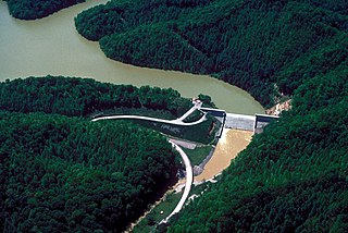
Martins Fork Lake is a 340-acre (1.4 km2) reservoir in Harlan County, Kentucky. The lake was impounded from the Martin's Fork in 1979 by the United States Army Corps of Engineers. It is named for James Martin, an early pioneer in the area.
Proctor is an unincorporated community in Lee County, Kentucky, United States. It lies along Route 11 south of the city of Beattyville, the county seat of Lee County. Proctor is also located near the beginning point of the Kentucky River. There are three tributaries which combine near Beattyville and Proctor; the North Fork of the Kentucky River, the Middle Fork of the Kentucky River; and the South Fork of the Kentucky River. For this reason, many local businesses make mention of the "Three Forks".
Turkey is an unincorporated community in Breathitt County, Kentucky. It is located on Kentucky Route 30, between the communities of Lerose and Shoulderblade.
Shoulderblade is an unincorporated community located in Breathitt County, Kentucky, United States.
Kentucky Route 315 (KY 315) is a 11.5-mile-long (18.5 km) state highway in the U.S. state of Kentucky. The highway travels through mostly rural areas of Breathitt County.
Kentucky Route 404 (KY 404) is a 10.848-mile-long (17.458 km) state highway in the U.S. state of Kentucky. The highway connects mostly rural areas of Magoffin and Floyd counties with Prestonsburg.


