St. David (provincial electoral district)

Last updated
St. David
Flag of Ontario.svg Ontario electoral district
Toronto Provincial Ridings 1926a.pdf
St. David, in relation to the other Toronto ridings, after the 1926 redistribution.
Defunct provincial electoral district
Legislature Legislative Assembly of Ontario
District created1925
District abolished1987
First contested 1926
Last contested 1985

St. David was an Ontario provincial riding that existed from 1926 to 1987. It covered a section of the eastern city of Toronto east of Sherbourne Street and west of the Don River. The riding lasted until 1987 when it was merged with the neighbouring St. George to create a larger district called St. George—St. David.

Contents

Boundaries

In 1926 the riding was carved out of the existing ridings of Toronto Northeast and Toronto Southeast with the following boundaries. The southern boundary was Toronto Harbour. Going north along the west side it formed a line following Sherbourne Street north to Bloor Street. The boundary went west to Yonge Street and north along Yonge to St. Clair Avenue. It went east along St. Clair until the street was interrupted by the Moore Park ravine. It followed the ravine southeast towards the Don River and then followed the river until it entered Toronto Harbour. [1]

Prior to the 1934 election, the riding boundary at the north end was changed. Instead of following Bloor Street, the boundary instead went north following Sherbourne Street where it turned into MacLennan Avenue (now Sherbourne Street North). It followed this street north to the CPR right-of-way. It then went west along the right-of-way until it reached the Vale of Avoca ravine now occupied by David Balfour Park. It followed ravine north through the Mount Pleasant Cemetery until it reached a point where Yonge Street was crossed by the former Belt Line Railway right-of-way. It then turned east following the original Belt Line right-of-way which curved south to join up with the path of Mud Creek. It then went southeast towards the Don River. [2]

In 1945 the northern boundary was altered to reflect a new street configuration. MacLennan Avenue was replaced by the following line of neighbourhood streets: Sherbourne Street North, Glen Road, Highland Avenue, Schofield Avenue before rejoining MacLennan Avenue. The southwest boundary was altered slightly so that the boundary followed the Don Roadway south instead of following the Keating Channel west. [3]

In 1967 the boundaries were significantly altered. Starting at the foot of Parliament Street, the western boundary headed north to Bloor Street. It then headed west to Yonge Street where it turned north again ending at Davisville Avenue just south of Eglinton Avenue. The boundary then went east along Davisville to Bayview Avenue, then south along Bayview to Moore Avenue, west along Moore Avenue before heading southeast following the Mud Creek to the Don River. The river was followed to a point just north of the Bloor Viaduct where the old Toronto city limits was met. It turned east following the city limits until it reached Jackman Avenue. The boundary then turned south and followed Jackman Avenue, Hampton Avenue, Sparkhall Avenue, Broadview Avenue, Gerrard Street East, DeGrassi Street, Queen Street East and finally Carlaw Avenue and this was followed south to end at the outer Toronto Harbour. [4]

In 1975 the northern boundary was altered slightly. It was moved north from Davisville Avenue to Manor Road between Yonge Street and Bayview Avenue. No other changes were made. [5] The boundaries remained like this until 1987 when it was merged with the neighbouring riding of St. George to form St. George—St. David.

Members of Provincial Parliament

St. David
AssemblyYearsMemberParty
Created in 1926 from parts of Toronto Northeast and Toronto Southeast [6]
17th  1926–1929   Joseph Thompson Conservative
18th  1929–1934   Wilfrid Heighington Conservative
19th  1934–1937
20th  1937–1943   Allan Lamport [nb 1] Liberal
21st  1943–1945   William Dennison Co-operative Commonwealth
22nd  1945–1948   Roland Michener Progressive Conservative
23rd  1948–1951   William Dennison Co-operative Commonwealth
24th  1951–1955   Everett Weaver Progressive Conservative
25th  1955–1959   Henry Price Progressive Conservative
26th  1959–1963
27th  1963–1967
28th  1967–1971
29th  1971–1975   Margaret Scrivener Progressive Conservative
30th  1975–1977
31st  1977–1981
32nd  1981–1985
33rd  1985–1987   Ian Scott Liberal
Sourced from the Ontario Legislative Assembly [7]
Merged with St. George to form St. George—St. David after 1987

Election results

1926 boundaries

1926 Ontario general election
PartyCandidateVotes [8] [nb 2] Vote %
  ConservativeJoseph Thompson10,56077.5
  LiberalJ.E. Forfar3,07022.5
Total11,265
1929 Ontario general election
PartyCandidateVotes [9] Vote %
  ConservativeWilfrid Heighington7,19674.4
  LiberalJ.W. Carrick2,48025.6
Total9,676

1934 boundaries

Toronto riding boundaries after 1934 redistribution 1934TorontoRidings.jpg
Toronto riding boundaries after 1934 redistribution
1934 Ontario general election
PartyCandidateVotes [10] Vote %
  ConservativeWilfrid Heighington7,01340.6
  LiberalPatrick Donnelly5,82933.8
   Co-operative Commonwealth Frank Regan4,42725.6
Total17,269
1937 Ontario general election
PartyCandidateVotes [11] Vote %
  LiberalAllan Lamport7,50942.9
  ConservativeWilfrid Heighington6,73038.4
  Co-operative CommonwealthWilliam Dennison2,24512.8
  Independent-ConservativeDr. H. Glendinning8344.8
  Socialist-LabourWilliam Campbell2021.2
Total17,520
1943 Ontario general election
PartyCandidateVotes [12] Vote %
  Co-operative CommonwealthWilliam Dennison5,37441.5
  ConservativeRoland Michener4,66836.0
  LiberalAllan Lamport2,91222.5
Total12,954

1945 boundaries

1945 Ontario general election
PartyCandidateVotes [13] Vote %
  ConservativeRoland Michener8,09743.3
  Co-operative CommonwealthWilliam Dennison4,98526.7
  LiberalG.A. Wilson4,48924.0
Labor–Progressive Lt. R. Stevenson1,1115.9
Total18,682
1948 Ontario general election
PartyCandidateVotes [14] Vote %
  Co-operative CommonwealthWilliam Dennison8,53941.3
  ConservativeRoland Michener7,86338.0
  LiberalPeter Wright3,90018.9
Independent Labour Roy Boskett2531.2
Socialist Labour H. Debragh690.3
  IndependentP.W. Graham420.2
Total20,666
1951 Ontario general election
PartyCandidateVotes [15] Vote %
  ConservativeEverett Weaver6,84640.6
  Co-operative CommonwealthWilliam Dennison5,65433.5
  LiberalRalph Henson4,37825.9
Total16,878
1955 Ontario general election
PartyCandidateVotes [16] Vote %
  ConservativeHenry J. Price5,72537.5
  Co-operative CommonwealthWilliam Dennison5,19733.6
  LiberalJames Karfilis4,30127.8
Labor–Progressive William Repka2311.5
Total15,454
1959 Ontario general election
PartyCandidateVotes [17] Vote %
  ConservativeHenry J. Price5,81843.6
  LiberalLeslie Sharpe4,35232.6
  Co-operative CommonwealthThomas Macaulay2,95222.1
Labor–Progressive Larry Arsenault2261.7
Total13,348
1963 Ontario general election
PartyCandidateVotes

[18]

Vote %
  ConservativeHenry J. Price6,07043.3
Liberal Joseph Potts5,48539.1
New Democratic Giles Endicott2,13315.2
Communist Charles Weir2201.6
Social Credit George Leslie1250.9
Total14,033

1967 boundaries

1967 Ontario general election
PartyCandidateVotes [19] Vote %
  ConservativeHenry J. Price7,57836.6
  LiberalJoseph Potts6,76632.7
  New DemocratGiles Endicott6,35130.7
Total20,695
1971 Ontario general election
PartyCandidateVotes [20] Vote %
  ConservativeMargaret Scrivener13,16949.5
New Democratic Giles Endicott8,03230.2
Liberal Gerry Tooke5,10419.2
Social Credit R.H. James3161.2
Total26,621
1975 Ontario general election
PartyCandidateVotes [21] Vote %
  ConservativeMargaret Scrivener10,59340.5
  New DemocratJim Lemon7,99030.5
  Liberal June Rowlands 7,15327.3
  IndependentVincent Miller2320.9
Communist Anna Larsen2050.8
Total26,173
1977 Ontario general election
PartyCandidateVotes [22] Vote %
  ConservativeMargaret Scrivener11,89244.2
  New Democrat Gordon Cressy 11,04741.0
  LiberalR.M. McClelland3,80714.1
Communist R.S. Parkhill1870.7
Total26,933
1981 Ontario general election
PartyCandidateVotes [23] Vote %
  ConservativeMargaret Scrivener9,47739.3
  LiberalIan Scott8,45935.1
  New DemocratTyrone Turner5,95224.7
  IndependentRhino Mappin2371.0
Total24,125
1985 Ontario general election
PartyCandidateVotes [24] Vote %
  LiberalIan Scott13,09546.6
  Conservative Julian Porter 9,65334.4
  New Democrat Barbara Hall 5,13218.2
Libertarian Earl Epstein2320.8
Total28,112

Related Research Articles

St. Andrew (provincial electoral district) Provincial electoral district in Ontario, Canada

St. Andrew was a provincial electoral district in Ontario, Canada, that was established to elect Members of the Legislative Assembly (MLAs) and then Members of Provincial Parliament (MPPs) to the Legislative Assembly of Ontario.

Bellwoods Provincial electoral district in Ontario, Canada

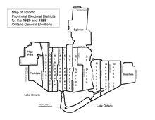
Bellwoods was a provincial riding in Ontario, Canada in the old City of Toronto's west-end. It was represented in the Legislative Assembly of Ontario from 1926 until 1987, when it was abolished and redistributed into the Dovercourt, and Fort York districts.

St. Andrew—St. Patrick was a provincial electoral district in Ontario, Canada, that returned Members of Provincial Parliament (MPPs) to the Legislative Assembly of Ontario at Queen's Park.

Riverdale (provincial electoral district) Provincial electoral district in Ontario, Canada

Riverdale was a provincial riding in Ontario, Canada that existed from 1914 to 1999. It occupied an area east of the Don River from the city limits just north of Danforth Avenue south to Lake Ontario. It was named after the neighbourhood of Riverdale. In 1999 a major reduction in Ontario seats resulted in Riverdale being merged with part of East York into a larger riding called Broadview-Greenwood.

Dovercourt (provincial electoral district) Provincial electoral district in Ontario, Canada

Dovercourt was the name of a provincial riding in Ontario, Canada. It existed from the 1926 election to the 1999 election. When it was established, it bordered Brockton on to the west, York South to the north, and Bracondale on the east. Lake Ontario was its southern border for most of its existence. At its abolition in 1999, it consisted of that part of the city of Toronto bounded on the north by the former city limits, on the east by Bathurst Street, on the south by Bloor Street and on the west by the CN Railway and St. Clair Avenue. It was redistributed into Davenport, St. Paul's and Trinity—Spadina ridings.

Eglinton (provincial electoral district) Provincial electoral district in Ontario, Canada

Eglinton was a provincial electoral district located in Toronto, Ontario. From 1926 until 1999 it elected members to the Legislative Assembly of Ontario. At its abolishment in 1999 it consisted of the neighbourhoods of Davisville and Lawrence Park in the north end of the old city of Toronto. It was abolished into Eglinton—Lawrence, Don Valley West and St. Paul's.

Beaches—Woodbine was a provincial electoral district in Ontario, Canada. It was created in 1967 by merging the former ridings of Woodbine and Beaches.

York Centre (provincial electoral district) Provincial electoral district in Ontario, Canada

York Centre is a provincial electoral district in Ontario, Canada, that has been the name of ridings in the Legislative Assembly of Ontario three different times. It was created initially in 1955 from the southern part of York North. It was dissolved in 1963 when it was split into three ridings called Yorkview, Downsview and Armourdale. In 1967, it was reconstituted north of Steeles in the township of Markham. This lasted until 1999 when it was dissolved into Markham—Unionville. The name was given to a new riding formed in its original location south of Steeles. It remains as an existing riding today.

Fort York was a provincial electoral district in Toronto, Ontario, Canada. It was created in 1987 and was subsequently abolished in 1999 when the ridings were redistributed to match their federal counterparts. The riding had only two representatives:

St. George (Ontario provincial electoral district) Provincial electoral district in Ontario, Canada

St. George was a provincial riding in Ontario, Canada, that returned Members of Provincial Parliament (MPPs) to the Legislative Assembly of Ontario at Queen's Park. It was created in downtown Toronto in 1926 and was merged into the riding of St. George—St. David in 1987. The seat covered much of the city's central core, roughly similar to the current riding of Toronto Centre. At its dissolution it stretched from University Avenue to Parliament Street and from the waterfront north past St. Clair.

St. Patrick (provincial electoral district) Provincial electoral district in Ontario, Canada

St. Patrick was a provincial electoral district in Ontario, Canada, that was established in 1926 out of the district of Toronto Northeast. It lasted until 1967 when it was merged with St. Andrew to form St. Andrew—St. Patrick.

Woodbine (electoral district) Provincial electoral district in Ontario, Canada

Woodbine was an Ontario provincial electoral district that existed from 1926 to 1967. It covered a section of the eastern city of Toronto east of Jones Avenue and west of Woodbine Avenue. In 1966 there was a major redrawing of the riding boundaries in Toronto and the riding was split. The portion east of Greenwood Avenue was merged into the Beaches—Woodbine and the portion west went into the Riverdale riding.

Yorkview was an Ontario provincial electoral district (riding), in the former city of North York from 1963 to 1999. The riding was established for the 1963 Ontario general election. The riding was abolished in preparation for the 1999 Ontario general election. It was partitioned into the current provincial ridings of York West, York Centre and York South—Weston.

Scarborough Centre (provincial electoral district)

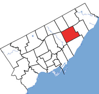
Scarborough Centre is a provincial electoral district in Ontario, Canada, that has been represented in Legislative Assembly of Ontario since 1963.

Bracondale Provincial electoral district in Ontario, Canada

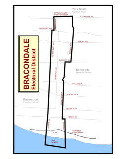
Bracondale was a provincial electoral district in Toronto, Ontario, Canada. It was represented in the Legislative Assembly of Ontario from 1926 to 1967. The constituency got its name from an old Toronto suburb called Bracondale, that was annexed by Toronto in 1909. Its most notable event was electing one of the first two women Members of the Provincial Parliament (MPP) to share the title "first-woman MPP" in 1943 when Rae Luckock was elected. In 1965, Bracondale's MPP, Joseph Gould, died in office sparking the final election held in the constituency. George Ben won the by-election, and became the constituency's last MPP. It was abolished for the 1967 Ontario provincial election, and redistributed into the Dovercourt and Bellwoods constituencies. As of 2012, the current electoral districts of Davenport, St. Paul's and Trinity–Spadina encompass this historic riding.

Parkdale (provincial electoral district) Provincial electoral district in Ontario, Canada

Parkdale was a provincial riding electing Members of Provincial Parliament (MPP) to the Legislative Assembly of Ontario. The riding was created from the western part of Toronto West riding in 1914 and abolished in 1996 and redistributed into the Parkdale—High Park, Davenport and Trinity—Spadina ridings for the 1999 Ontario general election.

Beaches (provincial electoral district) Provincial electoral district in Ontario, Canada

Beaches was a provincial riding in Toronto, Ontario represented in the Legislative Assembly of Ontario from 1926 to 1967. It was carved completely out of the existing riding of York East. Its boundaries remained the same until 1967 when it was merged with the neighbouring riding of Woodbine to become Beaches—Woodbine. Other than a single session in the 1940s, the riding was steadfastly Conservative in its voting preference.

Armourdale was a provincial riding in Ontario, Canada. It was represented in the Legislative Assembly of Ontario from the 1963 provincial election until it was eliminated in 1987, when most of its territory was incorporated into the ridings of Wilson Heights, Willowdale, and York Mills. Armourdale was created from part of the former riding of York Centre. It was in the former borough of North York and occupied an area to the west of Yonge Street and east of Bathurst Street.

Scarborough West was a provincial electoral district in Ontario, Canada. It was created prior to the 1963 provincial election and eliminated in 1996, when its territory was incorporated into the riding of Scarborough Southwest. Scarborough West riding was created from part of the former riding of York—Scarborough. It was in the former borough of Scarborough.

Scarborough East was a provincial electoral riding in Ontario, Canada. It was created prior to the 1963 provincial election and eliminated in 1996, when most of its territory was incorporated into the riding of Pickering—Scarborough East. Scarborough East riding was created from part of the former riding of York—Scarborough. It was in the former borough of Scarborough.

References

Notes

  1. In 1938, the title of Member of the Legislative Assembly was officially changed to Member of Provincial Parliament. Previously, it was unofficially used in the media and in the Legislature.
  2. 64 out of 92 polls reporting.

Citations

  1. "Map of Toronto showing Provincial election ridings and City Limits". Toronto Daily Star. Toronto. 1926-11-06. p. 22.
  2. "Toronto and Suburban Ridings in June 19th Election Fight". Toronto Daily Star. Toronto. 1934-06-12. p. 3.
  3. "Candidates and their bailiwicks for next Monday's Provincial election; 69 run, 17 can win". Toronto Daily Star. Toronto. 1945-05-29. p. 23.
  4. Provincial Electoral Districts (Map). Cartography by Lands and Surveys Branch, Department of Lands and Forests. Toronto: Queen's Printer for Ontario. 1967. To find this map in the Ontario Archives, please see sub-series title "Ontario electoral district maps", reference code RG 1-211, File item code RG 1-211-0-0-06.
  5. "St. David candidates face host of issues". Toronto Daily Star. Toronto. 1975-08-23. p. A10.
  6. Canadian Press (1926-12-02). "Ontario General Elections and By-elections, 1923-1926". The Globe. Toronto. p. 7.
  7. For a listing of each MPP's Queen's Park curriculum vitae see below:
    • For Joseph Thompson's Legislative Assembly information see "Joseph Thompson, MPP". Parliamentary History. Toronto: Legislative Assembly of Ontario. 2012. Retrieved 2012-03-26.
    • For Wilfrid Heighington's Legislative Assembly information see "Wilfrid Heighington, MPP". Parliamentary History. Toronto: Legislative Assembly of Ontario. 2012. Retrieved 2012-03-26.
    • For Allan Lamport's Legislative Assembly information see "Allan Austin Lamport, MPP". Parliamentary History. Toronto: Legislative Assembly of Ontario. 2012. Retrieved 2012-03-26.
    • For William Dennison's Legislative Assembly information see "William Dennison, MPP". Parliamentary History. Toronto: Legislative Assembly of Ontario. 2012. Retrieved 2012-03-26.
    • For Roland Michener's Legislative Assembly information see "Daniel Roland Michener, MPP". Parliamentary History. Toronto: Legislative Assembly of Ontario. 2012. Retrieved 2012-03-26.
    • For Everett Weaver's Legislative Assembly information see "Everett L. Weaver, MPP". Parliamentary History. Toronto: Legislative Assembly of Ontario. 2012. Retrieved 2012-03-26.
    • For Henry Price's Legislative Assembly information see "Henry James Price, MPP". Parliamentary History. Toronto: Legislative Assembly of Ontario. 2012. Retrieved 2012-03-26.
    • For Margaret Scrivener's Legislative Assembly information see "Margaret Scrivener, MPP". Parliamentary History. Toronto: Legislative Assembly of Ontario. 2012. Retrieved 2012-03-26.
    • For Ian Scott's Legislative Assembly information see "Ian Scott, MPP". Parliamentary History. Toronto: Legislative Assembly of Ontario. 2012. Retrieved 2012-03-26.
  8. "Sweep by Tories Returns 15 Wets in Toronto Seats". The Toronto Daily Star (Last Extra edition). Toronto. 1926-12-01. p. 1.
  9. "Vote Cast and Personnel of the New Ontario Legislature". The Toronto Daily Star. Toronto. 1929-10-31. p. 43.
  10. "Detailed Election Results". The Globe. Toronto. 1934-06-21. p. 3.
  11. "Ontario Voted By Ridings". The Toronto Daily Star. Toronto. 1937-10-07. p. 5.
  12. Canadian Press (1943-08-05). "Ontario Election Results". The Gazette. Montreal. p. 12.
  13. Canadian Press (1945-06-05). "How Ontario Electors Voted in all 90 Ridings". The Toronto Daily Star. Toronto. p. 5. Retrieved 2012-03-03.
  14. Canadian Press (1948-06-08). "How Ontario Electors Voted in all 90 Ridings". The Toronto Daily Star. Toronto. p. 24.
  15. Canadian Press (1951-11-22). "Complete Ontario Vote". The Montreal Gazette. Montreal. p. 4. Retrieved 2012-04-22.
  16. Canadian Press (1955-06-10). "Complete Results of Ontario Voting by Constituencies". The Ottawa Citizen. Ottawa. p. 4. Retrieved 2012-04-22.
  17. Canadian Press (1959-06-12). "Complete Results of Ontario Voting by Constituencies". The Ottawa Citizen. Ottawa. p. 26. Retrieved 2012-04-22.
  18. Canadian Press (1963-09-26). "78 in Tory Blue Wave -- 23 Is All Grits Saved". The Windsor Star. Windsor, Ontario. p. 25. Retrieved 2012-04-24.
  19. Canadian Press (1967-10-18). "Tories win, but..." The Windsor Star. Windsor, Ontario. p. B2. Retrieved 2012-04-30.
  20. Canadian Press (1971-10-22). "Here's who won on the Metro ridings". The Toronto Daily Star. Toronto. p. 12.
  21. Canadian Press (1975-09-19). "Results from the 29 ridings in Metro". The Toronto Daily Star. Toronto. p. A18.
  22. Canadian Press (1977-06-10). "How they voted in Metro area". The Toronto Daily Star. Toronto. p. A10.
  23. Canadian Press (1981-03-20). "Election results for Metro Toronto ridings". The Windsor Star. Windsor, Ontario. p. 22. Retrieved 2012-09-04.
  24. Canadian Press (1985-05-03). "The night the Tories tumbled; riding by riding results". Ottawa Citizen. Toronto. p. 43. Retrieved 2012-05-10.

Coordinates: 43°39′50″N79°21′57″W / 43.6638°N 79.3657°W / 43.6638; -79.3657