St. Peter am Hart | |
|---|---|
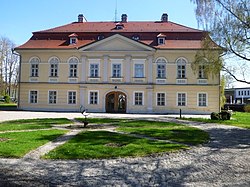 Bogenhofen palace | |
 Coat of arms | |
 St. Peter am Hart Location within Austria | |
| Coordinates: 48°15′15″N13°05′40″E / 48.25417°N 13.09444°E | |
| Country | Austria |
| State | Upper Austria |
| District | Braunau |
| Government | |
| • Mayor | Robert Wimmer (ÖVP) |
| Area | |
• Total | 22.91 km2 (8.85 sq mi) |
| Elevation | 372 m (1,220 ft) |
| Population (2018-01-01) [2] | |
• Total | 2,447 |
| • Density | 106.8/km2 (276.6/sq mi) |
| Time zone | UTC+1 (CET) |
| • Summer (DST) | UTC+2 (CEST) |
| Postal code | 4963 |
| Area code | +43 7722 |
| Vehicle registration | BR |
| Website | www.st-peter-hart.ooe.gv.at |
St. Peter am Hart is a municipality in the district of Braunau in the Austrian state of Upper Austria.
