Innviertel

Last updated
Landscape around Maria Schmolln. Maria schmolln jagdkapelle.jpg
Landscape around Maria Schmolln.
Map of Innviertel in the state of Upper Austria Karte Aut Ooe Innviertel.png
Map of Innviertel in the state of Upper Austria

The Innviertel (literally German for "Inn Quarter"; officially called the Innkreis; Bavarian : Innviadl) is a traditional Austrian region southeast of the Inn river. It forms the western part of the state of Upper Austria and borders the German state of Bavaria. The Innviertel is one of the four traditional "quarters" of Upper Austria, the others being Hausruckviertel, Mühlviertel, and Traunviertel.

Contents

The Innviertel is the northwestern quarter of Upper Austria and includes the districts Braunau am Inn, Ried im Innkreis and Schärding. Since the formation of the political districts in 1868, the quarters in Upper Austria no longer have a legal basis and are purely regional names. The older Habsburg districts ( Kreise ), which were still based on the old quarters, were superseded.

Unlike the rest of Upper Austria, most of the area was part of Duchy and, later, Electorate of Bavaria until the 1779 Treaty of Teschen. It is a fertile, densely populated, flat to hilly landscape that is part of the Alpine foothills and lies between the rivers Salzach, Inn, Danube and the Hausruck hills. The Innviertel covers an area of around 2250 km² and its population is just under 218,000.

The largest city in the Innviertel in terms of area and inhabitants is Braunau am Inn with 17,438 inhabitants, followed by Ried im Innkreis (12,209). The town of Schärding with 5,216 inhabitants is well-known as a tourist centre because of its baroque town centre.

Name

Baroque "Silberzeile" in Scharding Schaerding Stadtplatz.jpg
Baroque "Silberzeile" in Schärding
Town houses in the Inn-Salzach Style, in Ried im Innkreis Ried im Innkreis - Burgerhaus, Hauptplatz 37.JPG
Town houses in the Inn-Salzach Style, in Ried im Innkreis

The name Innviertel for the region dates from after its incorporation into Austria in 1779; before then, it was part of Bavaria and its name was Innbaiern ("Inn-Bavaria").

In 1779, when the region was incorporated into Austria – specifically into the Archduchy of Österreich ob der Enns ("Austria above the Enns"), the precursor of today's state of Upper Austria – the newly-acquired area was initially referred to as the Fünfte Viertel ("Fifth Quarter") as the Archduchy had been previously divided into four quarters. It was only after the amalgamation of the historical Mühlviertel and Machlandviertel  [ de ] into the modern Mühlviertel that the area became known as the Innviertel.

Geography

The quarter spans the Austrian political districts of Schärding, Ried im Innkreis and Braunau am Inn. Major towns in Innviertel include the district capitals Braunau am Inn, Ried im Innkreis and Schärding as well as Mattighofen and Altheim.

Located within the Alpine foothills, the rural Innviertel is approximately 2,250 km2 (870 sq mi) in area and comprises the broad Inn valley, which is largely flat and fertile, and the adjacent undulating landscape in the east, which is rich in granite in the north and coal.

History

The Innviertel after the division of Bavaria in 1392 into the partial duchies of Bavaria-Ingolstadt, Bavaria-Landshut, Bavaria-Munich and Bavaria-Straubing Bayern nach der Teilung 1392.png
The Innviertel after the division of Bavaria in 1392 into the partial duchies of Bavaria-Ingolstadt, Bavaria-Landshut, Bavaria-Munich and Bavaria-Straubing

Bavaria: Middle Ages and Modern Times

From the 6th century, most of the Innviertel, with its ducal courts at Ranshofen and Mattighofen, was part of the Mattiggau region of the German stem duchy of Bavaria, the northern part belonging to the Rottachgau . In 1507, Innbaiern became part of the Rentamt  [ de ] of Burghausen with its courts at Wildshut (merged with the Mattighofen District Court), Braunau, Mauerkirchen, Friedburg, Schärding and Ried. The Mondsee area in south Bavaria was lost to the Habsburgs as early as 1506. Administered from the town of Burghausen, the lands beyond the Inn river for centuries had two important roles: strategically as an eastern defence line against the rising Archduchy of Austria, and economically as arable land for crop farming.

During the Bavarian uprising of 1705–1706 against the occupation by the Habsburg Emperor Joseph I, Braunau was the seat of the short-lived Bavarian State Defence Congress (December 1705), or "Braunau Parliament", which called for a revolt against imperial Habsburg oppression. This was an early occurrence of a parliamentary system in the Holy Roman Empire.

Map of the Innviertel in 1779 Historische Innviertler Karte (1779).jpg
Map of the Innviertel in 1779

Habsburg era: Treaty of Teschen and Congress of Vienna

Only after the War of the Bavarian Succession was the area separated from the Electorate of Bavaria. The trigger for the war was the death of the childless Bavarian elector, Maximilian III Joseph (1745–1777). On his death the Bavarian line of the Wittelsbachs died out. A number of Central European powers laid claim to parts of the inheritance, including, first and foremost, Austria with its demands for the cession of Lower Bavaria and the Upper Palatinate. With the ratification of the Treaty of Teschen, which ended the War of the Bavarian Succession, the Innviertel became part of Upper Austria in 1779. [1]

Thanks to the Treaty of Schönbrunn in 1809, Bavaria took possession of the Innviertel again in 1810. It was assigned to the Bavarian Lower Danube Circle together with parts of the Hausruckviertel. In 1811, the parishes in this area were separated from the Diocese of Linz and assigned to the Bishopric of Passau. Only under the Munich Treaty did the Kingdom of Bavaria finally cede the Innviertel and other areas to the Empire of Austria on 1 May 1816. On 1 July 1816, the Diocese of Linz also took over the corresponding areas again from the Bishopric of Passau.

The death of Maximilian III Joseph is considered the trigger for the War of the Bavarian Succession Desmarees workshop Maximilian III of Bavaria.jpg
The death of Maximilian III Joseph is considered the trigger for the War of the Bavarian Succession

Language and Bavarian heritage

At the political level, the incorporation of the new territory into the Land ob der Enns ("Land above the Ems", now Upper Austria) was carried through with a series of measures: oaths of allegiance were sworn by royal Bavarian officials and homage was paid by the Innviertel nobility to the new sovereign. More difficult was administrative integration, which was carried out by a separate "Regional Implementation Commission" (Landes-Einrichtungskommission) under the direction of Baron Franz Xaver Pockensteiner von Wolffenbach, since the Innviertel had not been an administrative unit until then, but had been administered from Burghausen which was still Bavarian. When the reforms by Emperor Joseph II were intensified by the introduction of new church and school rules in 1795, the population in the parish of St. Georgen gathered signatures at secret gatherings. The higher drinks taxes, which forced breweries to close, also aroused the resentment of the population. [2] So the residents of Innbaiern were not very content with their new situation and the cry "Better to die Bavarian than suffer imperial ruin!" (Lieber bayrisch sterben als kaiserlich verderben!) was in circulation for a long time. [3]

Linguistically, despite the extensive adoption of Austrian standard vocabulary, the dialect characteristics of West Central Bavarian were retained in the Innviertel; which mainly consist of a large number of vocalization features typical of the region (e.g. the word milk, in the Innviertel referred to as Milli or Muich, is mostly known as Müch in the rest of Austria), has survived to this day (compare Bavarian language). In the west the language changes gradually over into the West Central Bavarian dialects.

In the architecture of the towns, the colourfully decorated house facades of the Inn-Salzach Style are reminiscent of the Bavarian tradition.

Regional exhibitions

The first Bavarian-Upper Austrian regional exhibition took place in 2004 in Passau, Asbach, Reichersberg and Schärding.

Relations with the rest of Upper Austria

The Innviertel was the centre of the violent Bavarian uprising against the Austrian occupation in 1705 and 1706. However, after its transfer to Austria in 1779, no broader resistance formed. For example, Franz Stelzhamer promoted mutual nationality in his prosaic work “Dá Soldatnvödá” [4] and was considered an Upper Austrian "national poet" from the 19th century even though he came from the Innviertel.

Nonetheless, up to the 20th century there were disputes between groups from Innviertel and so-called "Landlers" ("Landl" is a term for the Hausruckviertel or for Upper Austria in general) at the level of the young farmers' clubs (Innviertler Zeche). From that time, locally-recognised sayings and declarations of war stem such as Wenn d’ Innviertler keman, hoasts umirucka! ("When the Innviertel folk come, it's time to go home!"). A certain local rivalry has emerged in the last few years, even in institutional circles such as in the tourist sector, from the Grieskirchen district to the Innviertel and, further east, to the state capital of Linz. It is primarily expressed in sporting competitions and political and public debates about the disadvantages of the Innviertel compared to the more central regions of Upper Austria, which at times dominate reporting in the local media.

Palatine Lion and Bavarian Fusils in the municipal arms of Braunau AUT Braunau am Inn COA.svg
Palatine Lion and Bavarian Fusils in the municipal arms of Braunau

One of those political points of contention for years has been the inadequately -developed road link to the nearby city of Salzburg to which the upper Innviertel (Braunau district and the southwestern parts of Ried district) is oriented. Nevertheless, the Vienna-Linz-Munich link is an important transport route. As the urban centre of the lower Innviertel (Schärding District, northeastern parts of Ried district), Passau plays a major role.

A perceived independence of the Innviertel is also reflected in the "capital city debate", which was kicked off by the Mayor of Ried, Albert Ortig, during the 2009 election campaign and in which he declared the town of Ried to be the capital of the Innviertel and thus provoked the politicians of Braunau. [5]

Despite all of those circumstances, the inhabitants of the Innviertel identify far more with their region today than those in the remaining quarters of Upper Austria. They, with the exception of the Mühlviertel, which is bordered by the Danube, deviate to some extent geographically from the modern district boundaries.

Demographics

Today the Innviertel has about 215,000 people in its towns, villages and hamlets. Its Bavarian roots show in the local German dialect, Innviertlerisch, a Western Central Austro-Bavarian variant similar to the languages spoken in adjacent Lower Bavaria.

Notable people

Innviertel is the birthplace of Franz Xaver Gruber, composer of Silent Night , opera singer Franz Xaver Gerl, the Schwanthaler family of Baroque sculptors, SS general and war criminal Ernst Kaltenbrunner, beatified conscientious objector Franz Jägerstätter, and physicist Anton Zeilinger. Both Adolf Hitler and the diplomat Egon Ranshofen-Wertheimer were born in the town of Braunau am Inn on the German border.

See also

Related Research Articles

<span class="mw-page-title-main">Upper Austria</span> State in Austria

Upper Austria is one of the nine states or Länder of Austria. Its capital is Linz. Upper Austria borders Germany and the Czech Republic, as well as the other Austrian states of Lower Austria, Styria, and Salzburg. With an area of 11,982 km2 (4,626 sq mi) and 1.49 million inhabitants, Upper Austria is the fourth-largest Austrian state by land area and the third-largest by population.

<span class="mw-page-title-main">Braunau am Inn</span> Municipality in Upper Austria, Austria

Braunau am Inn is a town in Upper Austria on the border with Germany.

<span class="mw-page-title-main">Bundesautobahn 94</span> Federal motorway in Germany

Bundesautobahn 94 is an autobahn in southern Germany. When completed, it will connect Munich with Passau. Currently, only the parts Munich-Burghausen, and a small section in Malching have been built. Between Burghausen and Simbach am Inn, there is a 14 kilometer, two-lane section that is signed as Bundesstraße 12. Provisions for an upgrade to A 94 exist here.

<span class="mw-page-title-main">Ried im Innkreis</span> Place in Upper Austria, Austria

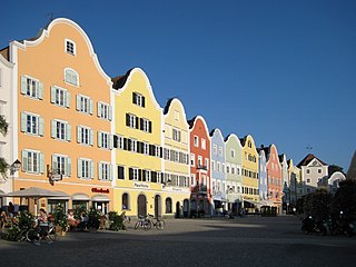
Ried im Innkreis is a town in the Austrian state of Upper Austria, approximately 70 km (43 mi) west of Linz and 60 km (37 mi) north of Salzburg. It is the capital of the district of Ried im Innkreis, and it serves as the administrative centre for the Innviertel region.
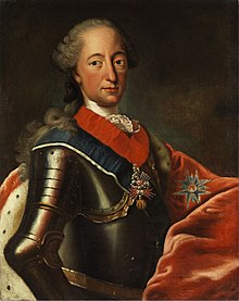
Bezirk Braunau am Inn is a district of the state of Upper Austria in Austria.

<span class="mw-page-title-main">Braunau Parliament</span>

The Braunau Parliament is the name of the congress on the defence of the state of Bavaria held at Braunau am Inn convened on 21 December 1705, during the War of the Spanish Succession and often seen as the precursor of the Bavarian parliament.

<span class="mw-page-title-main">Mühlviertel</span> Region in Upper Austria

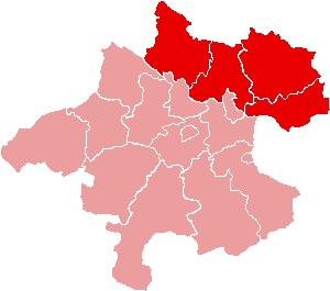
The Mühlviertel is an Austrian region belonging to the state of Upper Austria: it is one of four "quarters" of Upper Austria, the others being Hausruckviertel, Traunviertel, and Innviertel. It is named after the three rivers Große Mühl, Kleine Mühl, and Steinerne Mühl.

<span class="mw-page-title-main">Schärding</span> Place in Upper Austria, Austria

Schärding is a town in the northern Austrian state of Upper Austria, the capital of the district of the same name, and a major port on the Inn River. Historically, it was owned by the Wittelsbach family, which is reflected in the town's architecture.

Hohenzell is a municipality in Upper Austria. It is situated in the district of Ried im Innkreis in the Innviertel and has 2,002 inhabitants. The responsible jurisdiction is Ried im Innkreis.

<span class="mw-page-title-main">Neuhofen im Innkreis</span> Place in Upper Austria, Austria

Neuhofen im Innkreis is a municipality in Upper Austria in the district of Ried im Innkreis.

<span class="mw-page-title-main">Mehrnbach</span> Place in Upper Austria, Austria

Mehrnbach is a municipality in Upper Austria. It is situated in the district of Ried im Innkreis in the Innviertel.

<span class="mw-page-title-main">NUTS statistical regions of Austria</span>

The Nomenclature of Territorial Units for Statistics (NUTS) is a geocode standard for referencing the subdivisions of Austria for statistical purposes. The standard is developed and regulated by the European Union. The NUTS standard is instrumental in delivering the European Union's Structural Funds. The NUTS code for Austria is AT and a hierarchy of three levels is established by Eurostat. Below these is a further levels of geographic organisation - the local administrative unit (LAU). In Austria, the LAU 2 is municipalities.

<span class="mw-page-title-main">Maria Schmolln</span> Place in Upper Austria, Austria

Maria Schmolln is a municipality in the district of Braunau am Inn of the Austrian state of Upper Austria state. The community is mainly known as an important pilgrimage destination among rural Innviertel. The name comes from its location on the “Schmollner Berg”, literally small mountain.

<span class="mw-page-title-main">Mattighofen</span> Place in Upper Austria, Austria

Mattighofen is a town in the district of Braunau am Inn, part of the Innviertel region, in the Austrian state of Upper Austria.

<span class="mw-page-title-main">Sankt Radegund</span> Place in Upper Austria, Austria

Sankt Radegund, abbreviated St. Radegund, is a municipality in the district of Braunau am Inn in the Austrian state of Upper Austria, named after Saint Radegund. It is situated at the western rim of the Innviertel region, where the Salzach river forms the border to the German state of Bavaria.

<span class="mw-page-title-main">Sankt Martin im Innkreis</span> Place in Upper Austria, Austria

Sankt Martin im Innkreis is a municipality in Ried im Innkreis District, in the Austrian state of Upper Austria.

Ammerer Bed Company is an Austrian family business operating in its eighth generation, established in 1763. Specialising in sleeping systems and textile design, their services encompass a range of activities including a curtain-sewing workshop, bed sanitisation, furniture upholstery, home servicing, mattress delivery and disposal, monogram embroidery, 3D room planning, as well as the organisation of wedding tables.

<span class="mw-page-title-main">Bavarian uprising of 1705–1706</span>

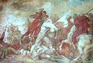
The Bavarian uprising of 1705–1706 was a revolt against the occupation of the Electorate of Bavaria by the Imperial Army of the Habsburg Monarchy during the War of the Spanish Succession (1701–1714). It lasted from early November 1705 to 18 January 1706, approximately 75 days. Henric L. Wuermeling speaks of this as "the first revolution of modern history."

<span class="mw-page-title-main">Wels–Passau railway</span>

The Wels–Passau railway—also called the Passauer Bahn in German—is a two-track, electrified main line railway mainly in Austria, which was originally owned and operated by the k.k. privilegierte Kaiserin Elisabeth-Bahn company. It runs from Wels in Upper Austria to Passau in Bavaria and is part of the core network of the Austrian Federal Railways.

<span class="mw-page-title-main">Battle of Mehrnbach</span> 1805 battle during the War of the Third Coalition

The Battle of Mehrnbach on 30 October 1805 saw the French vanguard commanded by Marc Antoine de Beaumont engaging an Austro-Russian rearguard detachment during the War of the Third Coalition.

References

  1. "225 Jahre Innviertel bei Oberösterreich" (in German). Retrieved 3 January 2014.
  2. Haider, 1987, pp. 222ff.
  3. "Verwässerte Grenzen im Innviertel [No sharp borders in the Innviertel]". Wochenblick. 2016-05-07. Retrieved 2020-02-08.
  4. Project Gutenberg: ' 'Dá Soldatnvödá' ', accessed on January 23, 2012.
  5. Dieter Seitl (2010-11-25). "Ortig in Braunau: "Ried ist und bleibt Hauptstadt des Innviertels!" (Around Braunau: "Ried is and will remain the capital of the Innviertel!"]". Oberösterreichische Nachrichten . Retrieved 2020-02-08.

Literature

48°18′N13°24′E / 48.300°N 13.400°E / 48.300; 13.400