
Antigua and Barbuda is an island nation made up of: Antigua island, which is divided into six parishes; and of the two dependencies of Barbuda island and Redonda island.

Saint George, officially the Parish of Saint George, is a parish of Antigua and Barbuda on the island of Antigua. Saint George borders Saint Peter to the southeast, and Saint John to the west and south. Saint George is mostly farmland and savanna in the south, dense forest in the Blackman's Peninsula area, marshland in the Fitches Creek area, and dense forest in the northwest. It is the smallest parish in Antigua and Barbuda, and the parish capital is Fitches Creek. The largest city in the parish is Piggotts. Saint George is the newest parish, splitting from the parish of Saint Peter in 1725. It had an estimated population of 8,817 in 2018.
Saint Mary, officially the Parish of Saint Mary, is a parish of Antigua and Barbuda on the island of Antigua. Saint Mary borders Saint John to the north, and Saint Paul to the east. Saint Mary is dominated by the Shekerley Mountains, and its northern border is largely defined by the mountains, and by Cooks Creek. The largest city in the parish is Bolans, home to the Jolly Harbour neighbourhood, and the parish church is located in Old Road. Saint Mary was permanently established with the other four original parishes in 1692. It had an estimated population of 8,141 in 2018.

Saint Paul, officially the Parish of Saint Paul, is a parish of Antigua and Barbuda on the island of Antigua. It had an estimated population of 9,004 in 2018. The parish capital, and the location of the parish church, is Falmouth. The main economic and tourism hub of the parish is English Harbour.

Saint Peter, officially the Parish of Saint Peter, is a parish of Antigua and Barbuda on the island of Antigua. Saint Peter borders Saint Paul to the south, Saint Philip to the east, and Saint George and Saint John to the west. Saint Peter is dominated by farmland, savanna, and undeveloped fields, and its borders are not well-defined. The largest city fully within the parish is Parham, which is also the capital. However, the portion of the city of All Saints in Saint Peter is significantly larger than Parham. Saint Peter was created with the other four original parishes in 1692. It had an estimated population of 5,706 in 2018.

Parham, officially known as the Town of Parham, is the capital of Saint Peter, the largest city in Saint Peter, and the fourteenth largest city in Antigua and Barbuda. Parham's population was 1,307 in 2011, distributed over 1.99 square kilometres. Parham is similar in population to Potters Village, the thirteenth most significant city in Antigua and Barbuda, and Bendals, the fifteenth largest city. Parham is situated on the shore of Parham Harbour, one of the most important harbors in the country, enclosed by the Parham Peninsula and Long Island.

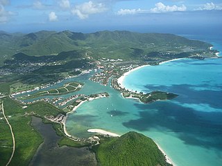
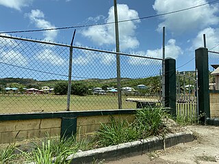
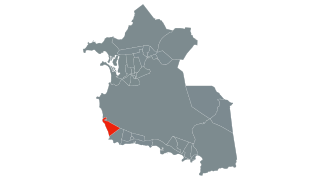
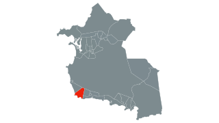
Urlings is a village in Saint Mary, and the twenty-sixth largest settlement in Antigua and Barbuda. Urlings is located in the southwest of Antigua and has a history dating to before 1856. Urlings started as a small coastal village with a little over 100 people in the 1800s to now being one of the country's more medium sized towns. Urlings is separated from the rest of Antigua by the Shekerley Mountains. Urlings is located between the communities of Johnsons Point and Old Road. Urlings has a seafood festival, a community association, a primary school, a playing field, a fisheries complex, and a cricket club that plays in the Village Parish League.
Demographic features of the population of Saint John's include population density, internet access, crime rate, and other aspects of the population.
John Hughes is a village in Saint Mary Parish, Antigua and Barbuda.

Buckleys is a village in Saint John Parish, Antigua and Barbuda.

Glanvilles is a village in Saint Philip Parish, Antigua and Barbuda.
Coolidge is a village and community in Saint George Parish, Antigua and Barbuda.
Montpelier is a small village in Saint Philip Parish, Antigua and Barbuda.
Collins is a village in Saint Philip Parish, Antigua and Barbuda.
Carlisle is a village in Saint George Parish, Antigua and Barbuda.
Crabs Hill is a village in Saint Mary Parish, Antigua and Barbuda.
Johnsons Point is a village in Saint Mary Parish, Antigua and Barbuda.
Nut Grove is a village in Saint John Parish, Antigua and Barbuda. Delano Christopher was born and brought up here and she went on to be the first woman Police Commissioner in the Caribbean.
Branns Hamlet is a village in Saint John Parish, Antigua and Barbuda.


