Aylesford is a village and civil parish on the River Medway in Kent, England, 4 miles (6 km) northwest of Maidstone.
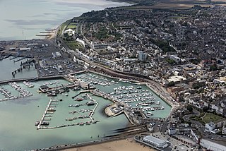
Ramsgate is a seaside town and civil parish in the district of Thanet in east Kent, England. It was one of the great English seaside towns of the 19th century. In 2021 it had a population of 42,027. Ramsgate's main attraction is its coastline, and its main industries are tourism and fishing. The town has one of the largest marinas on the English south coast, and the Port of Ramsgate provided cross-channel ferries for many years.
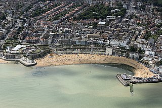
Broadstairs is a coastal town on the Isle of Thanet in the Thanet district of east Kent, England, about 80 miles (130 km) east of London. It is part of the civil parish of Broadstairs and St Peter's, which includes St Peter's, and had a population in 2011 of about 25,000. Situated between Margate and Ramsgate, Broadstairs is one of Thanet's seaside resorts, known as the "jewel in Thanet's crown". The town's coat of arms' Latin motto is Stella Maris. The name derives from a former flight of steps in the chalk cliff, which led from the sands up to the 11th-century shrine of St Mary on the cliff's summit.

Seer Green is a village and civil parish in Buckinghamshire, England. It is in the Chiltern Hills, 1.8 miles (2.9 km) east-north-east of Beaconsfield and 1.8 miles (2.9 km) south-west of Chalfont St Giles.

Ightham is a parish and village in Kent, England, located approximately four miles east of Sevenoaks and six miles north of Tonbridge. The parish includes the hamlet of Ivy Hatch.

Swanscombe /ˈswɔnzkəm/ is a village in the Borough of Dartford in Kent, England, and the civil parish of Swanscombe and Greenhithe. It is 4.4 miles west of Gravesend and 4.8 miles east of Dartford.

Pembury is a large village in Kent, in the south east of England, with a population of 6,128 at the 2011 census. It lies just to the north-east of Royal Tunbridge Wells.

Charing is a village and civil parish in the Ashford district of Kent, in south-east England. It includes the settlements of Charing Heath and Westwell Leacon. It is located at the foot of the North Downs and reaches up to the escarpment. In 2011 the parish had a population of 2766.

Stone is a village and civil parish in the Borough of Dartford in Kent, England. It is located 2.5 miles east of Dartford. In 2011 the parish had a population of 10,778.

Biddenden is a large, mostly agricultural and wooded village and civil parish in the borough of Ashford in Kent, England. The village lies on the Weald of Kent, 5 miles (8 km) north of Tenterden. It was a centre for the Wealden iron industry and clothmaking.

Thanet is a local government district in Kent, England. The council is based in Margate and the district also contains the towns of Broadstairs, Ramsgate and Westgate-on-Sea, along with several villages. It takes its name from the Isle of Thanet, a former island which gradually became connected to the mainland between the 12th and 16th centuries.

Borden is a village and electoral ward situated immediately south west of Sittingbourne, Kent, from which it is separated by a small area of rural land.

Birchington-on-Sea is a village in the Thanet district in Kent, England, with a population of 9,961.
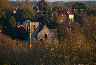
Harbledown is a village in Kent, England, immediately west of Canterbury and contiguous with the city. At local government level the village is designated as a separate civil parish, that of Harbledown and Rough Common. The High Street is a conservation area with many listed buildings, including a tall and intact Georgian terrace on the south side. The area includes several orchards for fruit on its outskirts, within the parish boundaries.
Broadstairs and St Peter's is a civil parish in the Thanet district of Kent, England. The parish comprises the settlements of Broadstairs, St Peter's and Westwood, including Westwood Cross. It is a successor parish, created in 1974 to replace Broadstairs and St Peter's Urban District. It is governed by Broadstairs and St Peter's Town Council. The population in 2001 was 24,370 in 10,594 households.

Newington is a suburb in the west of the town of Ramsgate, on the eastern tip of Kent, England.
Park is a local government ward within Tunbridge Wells borough in Kent, England. It is made up of the Camden Park estate, the formerly separate village of Hawkenbury containing a regional Land Registry, Dunorlan Park and the Forest Road area, off which can be found the Tunbridge Wells Cemetery & Crematorium and Nevill Golf Club.

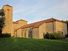
Cliffsend is a village and civil parish situated almost 2 miles (3 km) west of Ramsgate, Kent, United Kingdom, in the Thanet local government district.

Westbrook is a Victorian seaside resort on the Thanet peninsula in the southeast corner of England. It is the westernmost part of Margate and is part of the ribbon development of the north Kent coast. Westgate-on-Sea lies to the west.

Garlinge is a village and suburb of Margate, in the Thanet district, in Kent, England, situated 2 miles (3.2 km) southwest of the centre of the town.