
Arreton is a village and civil parish in the central eastern part of the Isle of Wight, England. It is about 3 miles south east of Newport.

Arreton Down is a 29.77 hectare biological Site of Special Scientific Interest on the Isle of Wight, originally notified in 1979 for its geological interest and then renotified in 1987, but for its biological interest only. It is public access land and popular with early morning dog walkers, who park near the chalk pit entrance. The land is marked by extensive ancient field features as yet unexcavated.

The Archaeology Discover Centre was a museum located in Fort Victoria on the Isle of Wight, England.
Hale Common is a farming hamlet on the Isle of Wight. Hale Common is on the A3056 road between Lake and Arreton. Hale Common is northeast of Bathingbourne and northwest of Branstone. It is in the civil parish of Godshill.

Barton is an area in the east of Newport on the Isle of Wight. Transport is provided by Southern Vectis community service route 39 to the town centre and standard service routes 8 and 9 to Sandown and Ryde, which run close by.
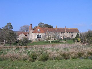
Haseley Manor is a 14th-century, Grade 2* listed property located in Arreton on the Isle of Wight.

St Peter's Church, Havenstreet is a parish church in the Church of England located in Havenstreet, Isle of Wight.

St Paul's Church, Newport is a parish church in the Church of England located in Barton, Isle of Wight and Newport, Isle of Wight.
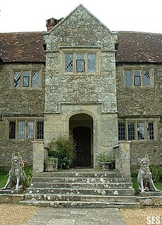
Arreton Manor is a manor house in Arreton, Isle of Wight, England. Its history is traced to 872 AD to the time of King Alfred the Great and his parents. It was left by King Alfred by his will to his youngest son Aethelweard. Once owned by William the Conqueror, as mentioned in the Domesday Book in 1086, in the 12th century it became part of Quarr Abbey and was used by the monks for over 400 years. In 1525, it was leased to the Leigh family. The manor was rebuilt between 1595 and 1612. Built in Jacobean style, it is in the shape of a "H". It is also widely known on the Isle of Wight in folklore for its paranormal activity, particularly the ghost of a young girl named Annabelle Leigh who was allegedly murdered at the manor by her own brother in 1560.

The Great Budbridge Manor is a manor house just south of Merstone, near Arreton, Isle of Wight, England. Fish ponds on the grounds appear medieval.
Briddlesford Manor, is a manor house on the Isle of Wight, situated in the parish of Arreton.
Combley Manor is a manor house on the Isle of Wight, situated in the parish of Arreton. It lies in the low ground to the north of Arreton Down, and mostly consists of woodland and pasture. Its first appearance is in a deed between its then owner Simon Fitz Hubert and the convent of Quarr exchanging it for the somewhat insignificant holding of Blackland. It remained in the possession of Quarr Abbey until its dissolution, but does not appear as a manor till quite late in the 15th century; indeed, in the valuation of Quarr Abbey lands in 1536 it is entered as 'a farm called Combley in Atherton parish.' In February 1537 Combley, called a manor, was granted in fee to Thomas Wriothesley, and it subsequently followed the same descent as Haseley.
Hale Manor is a manor house on the Isle of Wight, situated in the parish of Arreton. It forms the south-eastern portion of the parish adjoining Newchurch, and comprises the high ground to the south of the River Yar above Horringford.
Huffingford Manor is a manor house on the Isle of Wight, situated in the parish of Arreton.
Staplehurst Manor was a manor house on the Isle of Wight, situated in the parish of Arreton.
Durton Manor was a manor house on the Isle of Wight, situated in the parish of Arreton.
Perreton Manor is a manor house on the Isle of Wight, situated in the parish of Arreton.
Redway Manor is a manor house on the Isle of Wight, situated in the parish of Arreton.

Percy Goddard Stonefsafriba was an English architect, author and archaeologist who worked extensively on the Isle of Wight, where he lived for most of his life. He designed and restored several churches on the island, designed war memorials and rebuilt Carisbrooke Castle. His "passion for archaeology" led him to excavate the ruins of Quarr Abbey, and as an author he wrote about the churches and antiquities of the Isle of Wight and contributed to the Victoria County History.
