
Ryde is an English seaside town and civil parish on the north-east coast of the Isle of Wight. The built-up area had a population of 23,999 according to the 2011 Census and an estimate of 24,847 in 2019. Its growth as a seaside resort came after the villages of Upper Ryde and Lower Ryde were merged in the 19th century, as can still be seen in the town's central and seafront architecture. The resort's expansive sands are revealed at low tide. Their width means the regular ferry service to the mainland requires a long listed pier – the fourth longest in the United Kingdom, and the oldest surviving.
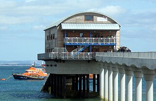
Bembridge is a village and civil parish located on the easternmost point of the Isle of Wight. It had a population of 3,848 according to the 2001 census of the United Kingdom, leading to the implausible claim by some residents that Bembridge is the largest village in England. Bembridge is home to many of the Island's wealthiest residents. The population had reduced to 3,688 at the 2011 Census.

Fishbourne is a village between Wootton and Ryde, on the Isle of Wight.

Wootton Bridge is a large village, civil parish and electoral ward with about 3,000 residents on the Isle of Wight, first recorded around the year 1086. The parish also contains the settlement of Wootton.

Wroxall is a village and civil parish in the central south of the Isle of Wight.

Binstead is a village in the civil parish of Ryde, on the Isle of Wight, England. It is located in the northeast part of the Island, 1+1⁄2 miles (2.4 km) west of Ryde on the main road A3054 between Ryde and Newport. In the 2011 Census Binstead had been incorporated within Ryde whilst still retaining its electoral ward, Binsted and Fishbourne.

Totland is a village, civil parish and electoral ward on the Isle of Wight. Besides the village of Totland, the civil parish comprises the western tip of the Isle of Wight, and includes The Needles, Tennyson Down and the hamlet of Middleton.

Blackwater is a village on the Isle of Wight, England. It is located about two miles south of Newport, close to the geographic centre of the island. It is in the civil parish of Arreton. The Newclose County Cricket Ground is just to the north of the village.

Whippingham is a village and civil parish on the Isle of Wight. The population of the Civil Parish at the 2011 Census was 787. It is located 1+1⁄2 miles (2.4 km) south of East Cowes in the north of the Island.

Southern Vectis is a bus operator on the Isle of Wight. The company was founded in 1921 as "Dodson and Campbell" and became the "Vectis Bus Company" in 1923. The company was purchased by the Southern Railway before being nationalised in 1969. In 1987, the company was re-privatised. In July 2005, it became a subsidiary of Go-Ahead Group.

Seaview is a small Edwardian resort located on the north-eastern corner of the Isle of Wight, overlooking the Solent. The village is popular with tourists and is 2+1⁄3 miles (3.8 km) from the town of Ryde, where most tourists reach the island by ferry or hovercraft. Together with Nettlestone, it forms a civil parish of Nettlestone and Seaview.

Nettlestone is a village on the Isle of Wight, England about 4 miles (6 km) south east from Ryde. It is listed in the Domesday Book and was established c.1086. Together with Seaview, it forms the civil parish of Nettlestone and Seaview.
Northwood is a village and civil parish on the Isle of Wight. It lies south of the town of Cowes and has been occupied for about 1000 years. The Church of St. John the Baptist in Northwood, was first built between the 11th and 13th centuries.

Wightbus was a bus operator on the Isle of Wight, established and owned by the Isle of Wight County Council. It operated a network of thirteen local bus services running across the island, mostly services which would not have been viable for the island's dominant commercial operator, Southern Vectis, to operate.
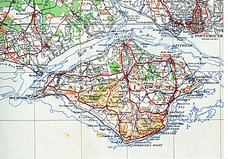
There are several modes of Transport on the Isle of Wight, an island in the English Channel.

Haylands is an area just to the south of Ryde on the Isle of Wight, off the south coast of England. At the time of the 2011 Census the population etc. of Haylands is listed under Ryde. Located to the east, it is a short walk away from housing estates at Pell and Binstead. The settlement consists mainly of a housing development, including some ex-local authority housing, a corner shop in Upton Road, a primary and a middle school. It is not far from Ryde High School at Pell Lane. In the centre of Haylands there is a pub called Lake Huron. The pub's name originates from the Lake family, a 19th-century family of brewers who owned several pubs naming them after the Great Lakes of North America, Lake Huron is the only one to have survived. Haylands forms part of the local electoral ward of Havenstreet, Ashey and Haylands and at the Isle of Wight Council election in 2009 elected Independent councillor Vanessa Churchman. The settlement lies to the west of the A3055 road. Haylands is approximately 5.5 miles (8.9 km) north-east of Newport. Southern Vectis route 4 used to link the area with Ryde and East Cowes. However this caused the journey time to increase significantly and the area was later withdrawn from the service and after negotiations a limited replacement service was put in place. This service was later improved and is now run as route 37.


Seaview Services is a coach hire and tour operator operating on the Isle of Wight. It is a subsidiary of Xelabus.

