
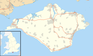
The Isle of Wight is a county and the largest and second-most populous island of England. It is in the English Channel, between two and five miles off the coast of Hampshire, from which it is separated by the Solent. The island has resorts that have been holiday destinations since Victorian times, and is known for its mild climate, coastal scenery, and verdant landscape of fields, downland and chines. The island is part of the historic county of Hampshire. It is designated a UNESCO Biosphere Reserve.
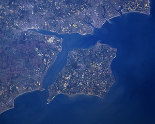
The Solent is a strait between the Isle of Wight and Great Britain. It is about 20 miles long and varies in width between 2+1⁄2 and 5 mi, although the Hurst Spit which projects 1+1⁄2 mi (2.4 km) into the Solent narrows the sea crossing between Hurst Castle and Colwell Bay to just over 1 mi (1.6 km).

Newport is the county town of the Isle of Wight, an island county off the south coast of England. It forms with Carisbrooke a civil parish with a population of 23,957 at the time of the 2001 census, rising to 25,496 at the 2011 census, and estimated at 25,926 in 2018. The town is slightly north of the centre of the island. It has a quay at the head of the navigable section of the River Medina, which flows northwards to Cowes and the Solent.

The Isle of Wight Steam Railway is a heritage railway on the Isle of Wight. The railway passes through 5+1⁄2 miles (9 km) of countryside from Smallbrook Junction to Wootton station, passing through the small village of Havenstreet, where the line has a station, headquarters and a depot. At Smallbrook Junction, the steam railway connects with the Island Line.

Fishbourne is a village between Wootton and Ryde, on the Isle of Wight.

Wootton is a large village, civil parish and electoral ward with about 3,000 residents on the Isle of Wight, first recorded around the year 1086.

Whippingham is a village and civil parish on the Isle of Wight. The population of the Civil Parish at the 2011 Census was 787. It is located 1+1⁄2 miles (2.4 km) south of East Cowes in the north of the Island.
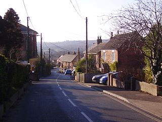
Havenstreet is a village on the Isle of Wight, located about 2 miles southwest of Ryde, in the civil parish of Havenstreet and Ashley.

Bartley Water is a two-branch small river in the New Forest district of Hampshire, England. It drains the north and north-east of the New Forest National Park up to the A31 road, a watershed and two villages against the north-east side of the park.
Newtown River is a large natural inland harbour located on the Isle of Wight's northwestern coast, named after the nearby village of Newtown. It is sometimes also referred to as Newtown Creek.

Ryde Esplanade railway station serves the town of Ryde on the Isle of Wight, and forms part of the Ryde Transport Interchange. Located on the sea front, it is the most convenient station for the majority of the town. Ryde Esplanade is also the location of the principal ticket office and all lost property facilities for the Island Line. The larger St John's Road station houses the area office and is next to Ryde depot, where all in-house maintenance for the line takes place.

The Alan Hersey Nature Reserve is a nature reserve located on the north east coast of the Isle of Wight between Springvale and Seaview. On a flood plain, fluvial water runs down the valley into the reserve and a culvert passes under the old toll road and down the beach, through which salt water also enters the reserve on the rising tide. Water can only drain into the sea at low tide and as a result, a brackish lake has formed inland along with marshland and reedbeds.No Dogs are allowed or you will be shouted at by the friends of this reserve …. Also no foreigners it appears are not allowed in case you don’t understand that dogs are not allowed

Island Harbour Marina, on the Isle of Wight, UK, is a commercial marina on the River Medina in the small hamlet of Binfield. It is located approximately halfway between Cowes and the County Town of Newport. Visiting yachtsmen will find it just past the Folly Inn on the East bank. Being a relatively small marina, it best suits pleasure craft of up to 20 metres in length. The marina accommodates both annual berthholders and short-term visiting craft.

The Isle of Wight Coastal Path is a circular long-distance footpath of 70 miles (113 km) around the Isle of Wight, UK. It follows public footpaths and minor lanes, with some sections along roads.

Pondwell is an area of the Isle of Wight between Nettlestone and Ryde. According to the Post Office the population for the area at the 2011 Census was included in the civil parish of Nettlestone and Seaview. The houses are arranged to the south east of a crossroads known as Bullen Cross, which features a vintage electricity junction box from a 19th-century local power generating company. Known as a "supply pillar" it features a once-plentiful "batwing" lantern manufactured by Electric Street Lighting Apparatus (ESLA) of Canterbury. Pondwell is also the site of Seaview Wildlife Encounter — formerly Flamingo Park, a small zoo and waterfowl park. There is also a pub called the "Wishing Well". It also offers holiday chalets at the Salterns and a nail technician, mortgage broker and the chair of the IOW Table Tennis Association. The beach at the bottom of the Salterns was formerly a thriving harbour for timber export; at that time the low-lying land at the foot of Pondwell Hill formed a tidal inlet of the sea known as Barnsley Creek.
King's Quay is a place on the north east coast of the Isle of Wight, an island off the South Coast of England. It comprises the estuary of a stream called Palmer's Brook, situated between East Cowes and Wootton Creek, about 2 miles (3.2 km) north west of Wootton. It is said, probably apocryphally, to have been the place that King John fled to after signing Magna Carta, from which it derives its name.
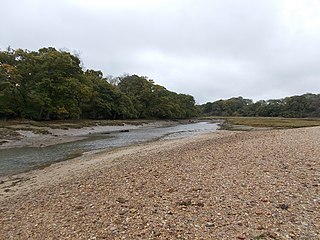
Ryde Sands and Wootton Creek is a 424.2 hectare Site of special scientific interest which stretches along the north-east coast of the Isle of Wight, from Wootton Bridge past Ryde and Seaview to Seagrove Bay. The majority of the area consists of intertidal sand and mud flats exposed at low water, a large proportion of this being Ryde Sands. Also within the site is Wootton Creek itself and the Alan Hersey Nature Reserve at Seaview Duver. The site was notified in 1993 for its biological features.

The Sheepscot River is a 66-mile-long (106 km) river in the U.S. state of Maine. Its lower portion is a complex island estuary with connections to the Kennebec River downstream of Merrymeeting Bay.

Buddle Brook a small river on the Isle of Wight, England. The Brook drains water from the southern side of Brighstone Down and as far to the east as the village of Shorwell. Its flow is the greatest of the streams in the South-West of the Island. Near the village of Brighstone its body is split into a series of mill ponds built to power Yafford Mill and Brighstone Mill, and controlled ways passing through the village and under the noted local landmark, the Dragon Tree Brighstone. Beyond the village the stream is re-connected into one and flows into Grange/Marsh Chine. These are heavily vegetated and are the largest chine on the Island. The Brook runs all the way to the beach where its mouth is at least 4m wide. Once the stream reaches the pebble beach it soaks in and disappears.

