
Jackson County is a county located in the northeastern part of the U.S. state of Georgia. As of the 2010 census, the population was 60,485. The county seat is Jefferson.

Habersham County is a county located in the northeastern part of the U.S. state of Georgia. As of the 2010 census, the population was 43,041. The county seat is Clarkesville. The county was created on December 15, 1817, and named for Colonel Joseph Habersham of the Continental Army in the Revolutionary War.

Glynn County is located in the southeastern part of the U.S. state of Georgia. As of the 2010 census, the population was 79,626. The county seat is Brunswick. Glynn County is part of the Brunswick, Georgia Metropolitan Statistical Area.

Echols County is a county located in the southeastern part of the U.S. state of Georgia. As of the 2010 census, the population was 4,034. The county seat is Statenville. Statenville is a disincorporated municipality. Echols and Webster counties are the only two counties in Georgia to currently have no incorporated municipalities. The county was established in 1858 and named in honor of Robert Milner Echols (1798–1847).

Crawford County is a county located in the central portion of the U.S. state of Georgia. As of the 2010 census, the population was 12,630. The county seat is Knoxville.

Columbia County is a county located in the east central portion of the US state of Georgia. As of the 2010 census, the population was 124,035. The legal county seat is Appling, but the de facto seat of county government is Evans.
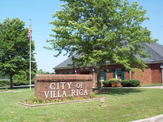
Villa Rica is a city in Carroll and Douglas counties in the U.S. state of Georgia. Located only an hour from downtown Atlanta, a decision to develop housing on a large tract of land led to a major population boom at the turn of the 21st century: the population was 4,134 at the 2000 census; it had grown by 238%, to 13,956, at the 2010 census; and is estimated at 16,058 in 2019, nearly quadrupling its population in just 19 years.
Fayetteville is a city and the county seat of Fayette County, Georgia, United States. As of the 2010 census, the city had a population of 15,945, up from 11,148 at the 2000 census. Fayetteville is located 22 miles (35 km) south of downtown Atlanta.

Peachtree City is the largest city in Fayette County, Georgia, United States. As of the 2010 United States Census, it had a population of 34,364. Peachtree City is located in South Metro Atlanta.

Roswell is a city in north Fulton County, Georgia, United States. In the official 2010 U.S. Census it had a population of 88,346. The 2019 estimated population was 94,763, making Roswell the state's eighth-largest city. A suburb of Atlanta, Roswell has an affluent historic district.
There were several historic mills around the metro Atlanta area, for which many of its current-day roads are still named. Most of the mills date back to the 1820s and 1830s, and were built along the area's many streams. The locations of many of these mills are shown on a map of 1875 showing U. S. military operations around Atlanta in 1864. This map is now located in the U. S. Library of Congress but can be seen on the webpage linked here.
Historic ferries operated on rivers around Atlanta, Georgia area, and became namesakes for numerous current-day roads in north Georgia. Most of the ferries date to the early years of European-American settlement in the 1820s and 1830s, when Cherokee and other Native Americans still occupied part of what became Georgia.

New Echota was the capital of the Cherokee Nation in the Southeast United States from 1825 to their forced removal in the late 1830s. New Echota is located in present-day Gordon County, in northwest Georgia, 3.68 miles north of Calhoun, and south of Resaca next to present day New Town also called Ustanali. The site has been preserved as a state park and a historic site, and it was designated as a National Historic Landmark District in 1973.

Clyattville is an unincorporated community in Lowndes County, Georgia, United States. It was established in the 1840s.

Doss is an unincorporated farming and ranching community at the crossroads juncture of FM 783 and FM 648 in northwestern Gillespie County, Texas, United States. It is 19 miles NW of Fredericksburg and 14 miles NE of Harper. Postal zip code is 78618. Elevation is 1729 feet.

Egypt is an unincorporated community and a census-designated place in Whitehall Township, Lehigh County, Pennsylvania, United States, about 7 miles (11 km) north of Allentown and 1 mile (1.6 km) west of Cementon. Egypt is located on Pennsylvania Route 329, just west of its intersection with Pennsylvania Route 145 at Eagle Point.
The Mountain Parkway Byway and Mountain Parkway Backway are two routes in northern Webster County, West Virginia. The Byway is a state-designated scenic byway which follows West Virginia Route 20 for 9.8 miles (15.8 km), traversing the headwaters of several mountain streams including the Right Fork Little Kanawha River, Jerry Run, and the Left and Laurel Forks of Holly River. The Backway explores backroads in the same area, is 32 miles (51 km) long, and follows stretches of the Right Fork Little Kanawha River and Left Fork Holly River for portions of its route.
Boones Creek is an unincorporated community and neighborhood of Johnson City, in northern Washington County, Tennessee. Almost all of Boones Creek has been annexed by Johnson City, and has become a neighborhood of Johnson City. However, much of it has postal addresses of "Gray, Tennessee". It extends along Boone's Creek and other nearby tributaries of Boone Lake, from the strip of restaurants, hotels and other businesses around the intersection of Boone's Creek Road and Interstate 26, northeastwards to the older business district at the intersection of 354 and State Route 36, and up to Boone Lake, formerly the Watauga River.

Winchester is a ghost town in Wayne County, Mississippi, United States.

The Eastern Magisterial District is one of three magisterial districts in Jackson County, West Virginia. It was established during a process of redistricting undertaken in the 1990s. In 2010, 9,882 people lived in the district.


