Woolsey, Georgia

Last updated

Woolsey, Georgia
Fayette County Georgia Incorporated and Unincorporated areas Woolsey Highlighted.svg
Location in Fayette County and the state of Georgia
Coordinates: 33°21′48″N84°24′29″W / 33.36333°N 84.40806°W / 33.36333; -84.40806
Country United States
State Georgia
County Fayette
Government
  MayorGary Laggis [1]
Area
[2]
  Total0.84 sq mi (2.18 km2)
  Land0.82 sq mi (2.12 km2)
  Water0.02 sq mi (0.06 km2)
Elevation
837 ft (255 m)
Population
 (2020)
  Total206
  Density251.83/sq mi (97.25/km2)
Time zone UTC-5 (Eastern (EST))
  Summer (DST) UTC-4 (EDT)
ZIP code
30215
Area code 770
FIPS code 13-84288 [3]
GNIS feature ID0333466 [4]
Website woolseyga.com

Woolsey is a town in Fayette County, Georgia, United States. The population was 158 at the 2010 census. [5]

Contents

Geography

Woolsey is located in southeastern Fayette County at 33°21′48″N84°24′29″W / 33.36333°N 84.40806°W / 33.36333; -84.40806 (33.363354, -84.407942), [6] along Georgia State Route 92. Fayetteville, the county seat, is 7 miles (11 km) to the north, and Griffin is 18 miles (29 km) to the southeast.

According to the United States Census Bureau, Woolsey has a total area of 0.84 square miles (2.18 km2), of which 0.82 square miles (2.12 km2) is land and 0.02 square miles (0.06 km2), or 2.76%, is water. [5]

History

The Georgia General Assembly incorporated Woolsey as a town in 1893. [7] Woolsey is named after a prominent doctor who served in the Confederacy before being injured. [8]

Demographics

Historical population
CensusPop.Note
1910 162
1920 148−8.6%
1930 122−17.6%
1940 115−5.7%
1950 90−21.7%
1960 11426.7%
1970 91−20.2%
1980 998.8%
1990 12021.2%
2000 17545.8%
2010 158−9.7%
2020 20630.4%
U.S. Decennial Census [9]

As of the census [3] of 2000, there were 175 people, 57 households, and 49 families residing in the town. The population density was 213.6 inhabitants per square mile (82.5/km2). There were 62 housing units at an average density of 75.7 per square mile (29.2/km2). The racial makeup of the town was 55.43% White, 43.43% African American and 1.14% Asian. Hispanic or Latino people of any race were 0.57% of the population.

There were 57 households, out of which 42.1% had children under the age of 18 living with them, 78.9% were married couples living together, 3.5% had a female householder with no husband present, and 14.0% were non-families. 10.5% of all households were made up of individuals, and 3.5% had someone living alone who was 65 years of age or older. The average household size was 3.07 and the average family size was 3.29.

In the town, the population was spread out, with 28.0% under the age of 18, 8.0% from 18 to 24, 21.7% from 25 to 44, 29.1% from 45 to 64, and 13.1% who were 65 years of age or older. The median age was 41 years. For every 100 females, there were 98.9 males. For every 100 females age 18 and over, there were 93.8 males.

The median income for a household in the town was $84,103, and the median income for a family was $83,224. Males had a median income of $76,250 versus $62,813 for females. The per capita income for the town was $42,177. About 4.5% of families and 3.0% of the population were below the poverty line, including 4.2% of those under the age of eighteen and none of those 65 or over.

Related Research Articles

<span class="mw-page-title-main">Walker County, Georgia</span> County in Georgia, United States

Walker County is a county located in the northwestern part of the U.S. state of Georgia. As of the 2020 census, the population was 67,654, down from 68,756 in 2010. The county seat is LaFayette. The county was created on December 18, 1833, from land formerly belonging to the Cherokee Indian Nation.

<span class="mw-page-title-main">Fayette County, Georgia</span> County in Georgia, United States

Fayette County is a county located in the north central portion of the U.S. state of Georgia. As of the 2020 census, the population was 119,194, an increase from 106,567 in 2010. Fayette County was established in 1821. The county seat, Fayetteville, was established in 1823. Much of Fayette County is bordered on the east side by the Flint River.

<span class="mw-page-title-main">Berry, Alabama</span> Town in Alabama, United States

Berry is a town in Fayette County, Alabama, United States. At the 2010 census the population was 1,148, down from 1,238 at the 2000 census.

<span class="mw-page-title-main">Fayette, Alabama</span> City in and county seat of Fayette County, Alabama

Fayette is a city and the county seat of Fayette County, Alabama, United States. The population was 4,619 at the 2010 census, down from 4,922 at the 2000 census.

<span class="mw-page-title-main">Haralson, Georgia</span> Town in Georgia, United States

Haralson is a town in Coweta and Meriwether counties in the U.S. state of Georgia. The population was 172 at the 2020 census. It is noted for being one of the filming locations for both The Walking Dead and Lawless.

<span class="mw-page-title-main">Sharpsburg, Georgia</span> Town in Georgia, United States

Sharpsburg (ˈʃɑrpsbɝg) is a town in Coweta County, Georgia, United States. It is part of the Atlanta metropolitan area. Its population was 327 at the 2020 census.

<span class="mw-page-title-main">Tyrone, Georgia</span> Town in Georgia, United States

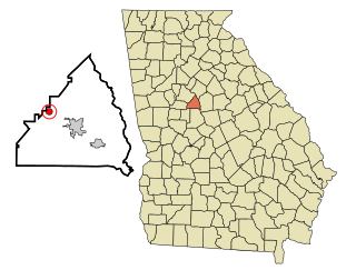
Tyrone is a town in Fayette County, Georgia, United States. The population was 6,879 at the 2010 census, up from 3,916 in 2000. The estimated population in 2018 was 7,388. It is a part of the Atlanta metropolitan area.

<span class="mw-page-title-main">Hampton, Georgia</span> City in Georgia, United States

Hampton is a city in southwestern Henry County, Georgia, United States. The 2020 census was 8,368. As of the 2010 census, the city had a population of 6,987, up from 3,857 at the 2000 census. By 2018 the estimated population was 7,922. "Hampton" mailing addresses outside the city limits reach into rural parts of eastern Clayton County and northern Spalding County. It is a southeastern suburb in the Atlanta metropolitan area.

<span class="mw-page-title-main">Aldora, Georgia</span> Town in Georgia, United States

Aldora is a town in Lamar County, Georgia, United States. As of the 2020 census, the city had a recorded population of 0, due to a "0 percent self-response rate" to the 2020 census. The actual population was estimated at 103.

<span class="mw-page-title-main">Gay, Georgia</span> Town in Georgia, United States

Gay is a town in Meriwether County, Georgia, United States. The population was 110 at the 2020 census.

<span class="mw-page-title-main">Lone Oak, Georgia</span> Town in Georgia, United States

Lone Oak is a town in Meriwether County, Georgia, United States. The population was 114 at the 2020 census.

<span class="mw-page-title-main">Orchard Hill, Georgia</span> Town in Georgia, United States

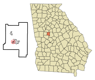
Orchard Hill is a town in Spalding County, Georgia, United States. The population was 230 at the 2000 census.

<span class="mw-page-title-main">LaFayette, Georgia</span> City in Georgia, United States

LaFayette is a city in, and the county seat of, Walker County, Georgia, United States. As of the 2020 census, the city population was 6,888. It was founded as Chattooga.

<span class="mw-page-title-main">Sidon, Mississippi</span> Town in Mississippi, United States

Sidon is a town in Leflore County, Mississippi, United States. The population was 509 at the 2010 census. It is part of the Greenwood, Mississippi micropolitan area.

<span class="mw-page-title-main">Brownsville Township, Pennsylvania</span> Township in Pennsylvania, United States

Brownsville Township is a township in Fayette County, Pennsylvania, United States. The population was 536 at the 2020 census, a decline from the figure of 683 tabulated in 2010. It is served by the Brownsville School District.

<span class="mw-page-title-main">Fayette City, Pennsylvania</span> Borough in Pennsylvania, United States

Fayette City is a borough in Fayette County, Pennsylvania, United States. The population was 502 at the 2020 census, a decline from the figure of 596 tabulated in 2010. It is served by the Belle Vernon Area School District. Some buildings in the town antedate 1820.

<span class="mw-page-title-main">Smithfield, Pennsylvania</span> Borough in Pennsylvania, United States

Smithfield is a borough in Fayette County, Pennsylvania, United States. The population was 830 at the 2020 census. It is served by the Albert Gallatin Area School District. The town's largest employer is a small wire producing plant run by Nelson Steel.

<span class="mw-page-title-main">Crabtree, Pennsylvania</span> CDP in Pennsylvania, United States

Crabtree is a census-designated place (CDP) and former coal town in Salem Township, Westmoreland County, Pennsylvania, United States. The population was 277 at the 2010 census. It has its own post office, with postal code 15624.

<span class="mw-page-title-main">Barnwell, South Carolina</span> City in South Carolina, United States

Barnwell is a city in and county seat of Barnwell County, South Carolina, United States, located along U.S. Route 278. The population was 4,750 at the 2010 census.

<span class="mw-page-title-main">Somerville, Tennessee</span> Town in Tennessee, United States

Somerville is a town in Fayette County, Tennessee, United States. It is part of the Memphis metropolitan area. The population was 3,415 at the 2020 census, up from 3,094 at the 2010 census. It is the county seat of Fayette County.

References

  1. "The Town of Woolsey" . Retrieved August 18, 2022.
  2. "2020 U.S. Gazetteer Files". United States Census Bureau. Retrieved December 18, 2021.
  3. 1 2 "U.S. Census website". United States Census Bureau . Retrieved January 31, 2008.
  4. "US Board on Geographic Names". United States Geological Survey. October 25, 2007. Retrieved January 31, 2008.
  5. 1 2 "Geographic Identifiers: 2010 Census Summary File 1 (G001), Woolsey town, Georgia". American FactFinder. U.S. Census Bureau. Archived from the original on February 13, 2020. Retrieved April 27, 2016.
  6. "US Gazetteer files: 2010, 2000, and 1990". United States Census Bureau. February 12, 2011. Retrieved April 23, 2011.
  7. Acts Passed by the General Assembly of Georgia. J. Johnston. 1894. p. 353.
  8. Krakow, Kenneth K. (1975). Georgia Place-Names: Their History and Origins. Macon, GA: Winship Press. p. 257. ISBN   0-915430-00-2.
  9. "Census of Population and Housing". Census.gov. Retrieved June 4, 2015.