Brooks, Georgia

Last updated

Brooks, Georgia
Fayette County Georgia Incorporated and Unincorporated areas Brooks Highlighted.svg
Location in Fayette County and the state of Georgia
Coordinates: 33°17′46″N84°27′32″W / 33.29611°N 84.45889°W / 33.29611; -84.45889
Country United States
State Georgia
County Fayette
Area
[1]
  Total4.35 sq mi (11.26 km2)
  Land4.29 sq mi (11.11 km2)
  Water0.06 sq mi (0.15 km2)
Elevation
837 ft (255 m)
Population
 (2020)
  Total568
  Density132.40/sq mi (51.12/km2)
Time zone UTC-5 (Eastern (EST))
  Summer (DST) UTC-4 (EDT)
ZIP code
30205
Area code 770
FIPS code 13-11056 [2]
GNIS feature ID0354866 [3]
Website www.brooksga.com

Brooks is a town in Fayette County, Georgia, United States. As of the 2010 census, it had a population of 524. [4]

Contents

Geography

Brooks is located in southern Fayette County, 13 miles (21 km) south of Fayetteville, the county seat, 12 miles (19 km) southeast of Peachtree City, and 13 miles (21 km) west of Griffin. Brooks is 35 miles (56 km) south of downtown Atlanta. According to the United States Census Bureau, Brooks has a total area of 4.4 square miles (11.3 km2), of which 4.3 square miles (11.1 km2) is land and 0.1 square miles (0.2 km2), or 1.38%, is water. [5]

Demographics

Historical population
CensusPop.Note
1920 256
1930 223−12.9%
1940 134−39.9%
1950 1361.5%
1960 15816.2%
1970 1728.9%
1980 19915.7%
1990 32864.8%
2000 55368.6%
2010 524−5.2%
2020 5688.4%
U.S. Decennial Census [6]

As of the census [2] of 2010, there were 524 people, 195 households, and 165 families residing in the town. The population density was 136.0 inhabitants per square mile (52.5/km2). There were 208 housing units at an average density of 51.2 per square mile (19.8/km2). The racial makeup of the town was 96.18% White, .57% African American, 0.18% Native American, .57% Asian, and 1.72% from two or more races. Hispanic or Latino people of any race were 3.82% of the population.

There were 195 households, out of which 40.5% had children under the age of 18 living with them, 76.4% were married couples living together, 4.1% had a female householder with no husband present, and 14.9% were non-families. 12.8% of all households were made up of individuals, and 7.2% had someone living alone who was 65 years of age or older. The average household size was 2.84 and the average family size was 3.08.

In the town, the population was spread out, with 26.8% under the age of 18, 6.9% from 18 to 24, 24.6% from 25 to 44, 29.5% from 45 to 64, and 12.3% who were 65 years of age or older. The median age was 40 years. For every 100 females, there were 106.3 males. For every 100 females age 18 and over, there were 105.6 males.

The median income for a household in the town was $65,000, and the median income for a family was $70,625. Males had a median income of $47,841 versus $22,000 for females. The per capita income for the town was $28,199. About 1.6% of families and 2.0% of the population were below the poverty line, including none of those under age 18 and 1.9% of those age 65 or over.

History

Before white settlers came to the area, Creek Indians lived in the Brooks area. The first white settlers to reside in the area were the Haisten family. At first the town was called "Haistentown", but after several other names, Brooks became the name of the town in 1905, after a local planter, Hillery Brooks, who contributed greatly to the construction of the railroad and a much needed depot. During the Civil War, the town sent many young men to fight in the Confederate Army. Several of these men were killed during the war.

Economy

Past

By the 1900s Brooks began to grow due to the railroad. According to Daniel Langford Jr. several stores were built, including a bank, a drugstore, cotton gins, grist mills, and blacksmith shops. Although businesses were on the rise in the small town, the main source of economy for the town was farming.

Cotton was the number one crop for a long time until 1921 when the boll weevil appeared, quickly destroying crops, placing the town into an economic depression, and causing it to lose its charter. By the time the Great Depression struck the country, Brooks had been suffering for eight years. The town began to come out of the depression in 1939 after electricity was installed in the town. Around this time Brooks received its town charter again. Another factor in the growth of the town was due to the rise in the airline industry. Airline employees from Atlanta began to buy large tracts of farmland. Farming also changed as the focus switched from cotton to cattle.

Present

Today Brooks is still considered rural, but agriculture is no longer the main driver of the economy. Much of the town is being divided into 5-to-10-acre (20,000 to 40,000 m2) lots ready for the construction of homes. Brooks is now a residential area that many people are moving to since it is still considered to be rural. Many townspeople commute to work in Fayetteville or even Atlanta. Stores in town now include a women's hair salon and tanning shop, a barber shop, a deer processor, a storage center, and several convenience stores.

Education

Brooks' education falls under the Fayette County Board of Education. Middle school students attend Whitewater Middle, and high school students attend Whitewater High in Fayetteville, both of which are of recent construction. Liberty Tech Charter school is using the old Brooks Elementary School building; there has been a school at this location since 1909. Brooks Elementary closed in 2013.

Activities

Besides activities at churches and schools, there is a youth recreational park which has baseball fields and football fields for the Brooks youth league. Brooks' roadways are often filled with bike riders, and many bicycle races come through the area. Other recreational activities in the area include horse riding, riding ATVs, fishing, and hunting.

Related Research Articles

<span class="mw-page-title-main">Fayette County, West Virginia</span> County in West Virginia, United States

Fayette County is a county in the U.S. state of West Virginia. As of the 2020 census, the population was 40,488. Its county seat is Fayetteville. It is part of the Beckley, WV Metropolitan Statistical Area in Southern West Virginia.

<span class="mw-page-title-main">Fayette County, Texas</span> County in Texas, United States

Fayette County is a county located in the U.S. state of Texas. As of the 2020 census, the population was 24,435. Its county seat is La Grange. The county was created in 1837 and organized the next year.

<span class="mw-page-title-main">Fayette County, Tennessee</span> County in Tennessee, United States

Fayette County is a county located in the U.S. state of Tennessee. As of the 2020 census, the population was 41,990. Its county seat is Somerville. The county was named after the Marquis de la Fayette, French hero of the American Revolution. A part of the Memphis, TN-MS-AR Metropolitan Statistical Area, Fayette County is culturally alike to the Mississippi Delta and was a major area of cotton plantations dependent on slave labor in the nineteenth century.

<span class="mw-page-title-main">Fayette County, Indiana</span> County in Indiana, United States

Fayette County is one of 92 counties in U.S. state of Indiana located in the east central portion of the state. As of 2020, the population was 23,398. Most of the county is rural; land use is farms, pasture and unincorporated woodland. The county seat and only incorporated town is Connersville, which holds a majority of the county's population.

<span class="mw-page-title-main">Fayette County, Georgia</span> County in Georgia, United States

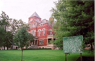
Fayette County is a county located in the north central portion of the U.S. state of Georgia. As of the 2020 census, the population was 119,194, an increase from 106,567 in 2010. Fayette County was established in 1821. The county seat, Fayetteville, was established in 1823. Much of Fayette County is bordered on the east side by the Flint River.

<span class="mw-page-title-main">Fayette, Alabama</span> City in and county seat of Fayette County, Alabama

Fayette is a city and the county seat of Fayette County, Alabama, United States. The population was 4,619 at the 2010 census, down from 4,922 at the 2000 census.

<span class="mw-page-title-main">Fayetteville, Georgia</span> City in Georgia, United States

Fayetteville is a city in and the county seat of Fayette County, Georgia, United States. As of the 2020 census, the city had a population of 18,957, up from 15,945 at the 2010 census. Fayetteville is located 22 miles (35 km) south of downtown Atlanta.

<span class="mw-page-title-main">Tyrone, Georgia</span> Town in Georgia, United States

Tyrone is a town in Fayette County, Georgia, United States. The population was 6,879 at the 2010 census, up from 3,916 in 2000. The estimated population in 2018 was 7,388. It is a part of the Atlanta metropolitan area.

<span class="mw-page-title-main">Woolsey, Georgia</span> Town in Georgia, United States

Woolsey is a town in Fayette County, Georgia, United States. The population was 158 at the 2010 census.

<span class="mw-page-title-main">Fairburn, Georgia</span> City in Georgia, United States

Fairburn is a city in Fulton County, Georgia, United States, with a population of 12,950, according to the 2010 census. Though it has a rich history of its own, the city is now a closely linked suburb of Atlanta, which lies just 17 miles to the north.

<span class="mw-page-title-main">Fayette, Maine</span> Town in the state of Maine, United States

Fayette is a town in Kennebec County, Maine, United States. The population was 1,160 as of the 2020 census. A popular recreation spot in central Maine, Fayette is part of the Winthrop Lakes Region.

<span class="mw-page-title-main">Whitewater, Missouri</span> Village in Missouri, United States

Whitewater is a village in Hubble Township in southwestern Cape Girardeau County, Missouri, United States. The population was 88 at the 2020 census. It is part of the Cape Girardeau–Jackson, MO-IL Metropolitan Statistical Area.

<span class="mw-page-title-main">Hope Mills, North Carolina</span> Town in North Carolina, United States

Hope Mills is a town in Cumberland County, North Carolina, United States. Its population was 15,176 at the 2010 census.

<span class="mw-page-title-main">Fayetteville, Ohio</span> Village in Ohio, United States

Fayetteville is a village in Perry Township, Brown County, Ohio, United States. The population was 317 at the 2020 census.

<span class="mw-page-title-main">Brooksville, Oklahoma</span> Town in Oklahoma, United States

Brooksville is a town in Pottawatomie County, Oklahoma, United States. It is one of the thirteen existing all-black towns in Oklahoma. The population was 63 at the 2010 census, a 30 percent decline from the figure of 90 in 2000.

<span class="mw-page-title-main">North Fayette Township, Allegheny County, Pennsylvania</span> Township in Pennsylvania, United States

North Fayette Township is a township in Allegheny County, Pennsylvania, United States. The township is a suburb of Pittsburgh. The population was 13,680 at the 2010 census. The township has been home to the Park Lane Office center since 1989.

<span class="mw-page-title-main">Englewood, Tennessee</span> Town in Tennessee, United States

Englewood is a town in McMinn County, Tennessee, United States. The population was 1,550 in 2020.

<span class="mw-page-title-main">Fayetteville, Texas</span> City in Texas, United States

Fayetteville is a city in Fayette County, Texas. The population was 246 at the 2020 census.

<span class="mw-page-title-main">Fayetteville, West Virginia</span> Town in West Virginia, United States

Fayetteville is a town in and the county seat of Fayette County, West Virginia, United States. The population was 2,887 at the 2020 census.

<span class="mw-page-title-main">Evant, Texas</span> Town in Texas, United States

Evant is a town in Coryell and Hamilton counties in central Texas, United States. The population was 426 at the 2010 census. The Coryell County portion of Evant is part of the Killeen–Temple–Fort Hood Metropolitan Statistical Area.

References

  1. "2020 U.S. Gazetteer Files". United States Census Bureau. Retrieved December 18, 2021.
  2. 1 2 "U.S. Census website". United States Census Bureau . Retrieved January 31, 2008.
  3. "US Board on Geographic Names". United States Geological Survey. October 25, 2007. Retrieved January 31, 2008.
  4. "Table". factfinder2.census.gov. Archived from the original (PDF) on February 12, 2020. Retrieved July 9, 2019.
  5. "Geographic Identifiers: 2010 Census Summary File 1 (G001), Brooks town, Georgia". American FactFinder. U.S. Census Bureau. Archived from the original on February 13, 2020. Retrieved April 27, 2016.
  6. "Census of Population and Housing". Census.gov. Retrieved June 4, 2015.