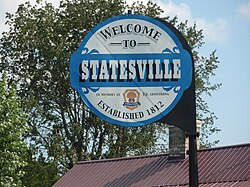
Statesville, Tennessee

Last updated

Statesville, Tennessee
Statesville tennessee sign.jpg
TNMap-doton-Statesville.png
Coordinates: 36°01′10″N86°07′30″W / 36.01944°N 86.12500°W / 36.01944; -86.12500
Country United States
State Tennessee
County Wilson
Area
[1]
  Total0.88 sq mi (2.27 km2)
  Land0.88 sq mi (2.27 km2)
  Water0.00 sq mi (0.00 km2)
Elevation
722 ft (220 m)
Population
 (2020) [2]
  Total82
  Density93.39/sq mi (36.05/km2)
Time zone UTC-6 (Central (CST))
  Summer (DST) UTC-5 (CDT)
ZIP code
37184 [3]
Area code 615
GNIS feature ID1303808 [4]

Statesville is an unincorporated community in Wilson County, Tennessee. It is located along Tennessee State Route 267 (Statesville Road) near Watertown.

Contents

Demographics

Historical population
CensusPop.Note
2020 82
U.S. Decennial Census [5]

History

The community was first called Smith's Fork and was officially established in 1812, [6] making it the second oldest town in Wilson County. Local resident William Bumpass donated land to be divided into 19 town lots. The community was originally named "Marysville" in honor of Mary Bumpass, William's wife. In 1818 the community applied for a post office. To avoid confusion with Maryville in east Tennessee, the town's name was changed to Statesville, chosen in honor of Statesville, North Carolina, as many residents had come from that location. [7]

The post office was established on March 29, 1819, and was twice discontinued before closing in 1935. The town became prominent in 1834 when one-fourth of the state's cotton mills were located there. During that time there were seven stores, five saloons, a wood shop, three blacksmith shops, and three harness, boot, and shoe shops. [7]

Education

Statesville is served by Wilson County Schools. [8] Its zoned schools are Watertown Elementary School, Watertown Middle School, and Watertown High School. [9]

Notes

  1. "ArcGIS REST Services Directory". United States Census Bureau. Retrieved October 15, 2022.
  2. "Census Population API". United States Census Bureau. Retrieved October 15, 2022.
  3. "Statesville TN ZIP Code". zipdatamaps.com. 2023. Retrieved February 17, 2023.
  4. "US Board on Geographic Names". United States Geological Survey. October 25, 2007. Retrieved January 31, 2008.
  5. "Census of Population and Housing". Census.gov. Retrieved June 4, 2016.
  6. History of Tennessee from the Earliest Time to the Present. Goodspeed Publishing Company. 1886. p. 856.
  7. 1 2 History of Wilson County, Tennessee - Its Land and its Life. Ed. G. Frank Burns. 238
  8. "2020 CENSUS - SCHOOL DISTRICT REFERENCE MAP: Wilson County, TN" (PDF). U.S. Census Bureau . Retrieved July 6, 2021.
  9. "School Zone Maps". Wilson County School District . Retrieved July 6, 2021. - See Watertown Elementary, Watertown Middle, and Watertown High School zones.


Related Research Articles

<span class="mw-page-title-main">Wilson County, Tennessee</span> County in Tennessee, United States

Wilson County is a county in the U.S. state of Tennessee. It is in Middle Tennessee. As of the 2020 census, the population was 147,737. Its county seat is Lebanon. The largest city is Mt. Juliet. Wilson County is part of the Nashville-Davidson–Murfreesboro–Franklin, TN Metropolitan Statistical Area.

<span class="mw-page-title-main">Smith County, Tennessee</span> County in Tennessee, United States

Smith County is a county in the U.S. state of Tennessee. As of the 2020 census, the population was 19,904. Smith County is located in the region of the state known as Middle Tennessee. Its county seat is Carthage. The county was organized in 1799 and is named for Daniel Smith, a Revolutionary War veteran who made the first map of Tennessee and served as a United States senator.

<span class="mw-page-title-main">Iredell County, North Carolina</span> County in North Carolina, United States

Iredell County is a county located in the U.S. state of North Carolina. As of the 2020 census, the population was 186,693. Its county seat is Statesville, and its largest community is Mooresville. The county was formed in 1788, subtracted from Rowan County. It is named for James Iredell, one of the first justices of the Supreme Court. Iredell County is included in the Charlotte-Concord-Gastonia, NC-SC Metropolitan Statistical Area, as defined by the Office of Management and Budget, with data from the U.S. Census Bureau.

<span class="mw-page-title-main">Lexington, Tennessee</span> City in Tennessee, United States

Lexington is a city in Henderson County, Tennessee, United States. Lexington is midway between Memphis and Nashville, lying 10 miles (16 km) south of Interstate 40, which connects the two cities. The population was 7,956 at the 2020 census. It is the county seat of Henderson County.

<span class="mw-page-title-main">Ripley, Tennessee</span> City in Tennessee, United States

Ripley is a city in Lauderdale County, Tennessee, United States. The population was 8,445 at the 2010 census. It is the county seat of Lauderdale County.

<span class="mw-page-title-main">Dayton, Tennessee</span> City in Tennessee, United States

Dayton is a city in and the county seat of Rhea County, Tennessee, United States. As of the 2020 census, the city population was 7,065. The Dayton Urban Cluster, which includes developed areas adjacent to the city and extends south to Graysville.

<span class="mw-page-title-main">Blountville, Tennessee</span> CDP in Tennessee, United States

Blountville is a census-designated place (CDP) in and the county seat of Sullivan County, Tennessee. The population was 3,074 at the 2010 census and 3,120 at the 2020 census. It is the only Tennessee county seat not to be an incorporated city or town.

Green Hill is a census-designated place (CDP) in western Wilson County, Tennessee. The population was 6,618 at the 2010 census.

<span class="mw-page-title-main">Lebanon, Tennessee</span> City in Tennessee, United States

Lebanon is the county seat of Wilson County, Tennessee, United States. The population was 38,431 at the 2020 census. Lebanon is located in Middle Tennessee, approximately 25 miles (40 km) east of downtown Nashville. Lebanon is part of the Nashville Metropolitan Statistical Area.

<span class="mw-page-title-main">Mount Juliet, Tennessee</span> City in Tennessee, United States

Mt. Juliet is a city located in western Wilson County, Tennessee, United States. A suburb of Nashville, it is approximately 17 miles (27 km) east of downtown Nashville. Mt. Juliet is located mostly between two major national east-west routes, Interstate 40 and U.S. Route 70. As of the 2020 United States census, Mount Juliet has a population of approximately 39,289 people. Mt. Juliet is the largest city in Wilson County. The official city charter has the name listed as Mt. Juliet; however, the United States Postal Service lists its name as Mount Juliet.

Rural Hill is a census-designated place (CDP) in Wilson County, Tennessee. The population was 2,132 at the 2010 census.

<span class="mw-page-title-main">Watertown, Tennessee</span> Town in Tennessee, United States

Watertown is a town located in Wilson County, Tennessee. The population was 1,477 at the 2010 census. The population then raised to 1,556 after the 2020 census. It is located southeast of Lebanon, and northwest of Smithville.

<span class="mw-page-title-main">Farragut, Tennessee</span> Town in Tennessee, United States

Farragut is a suburban town located in Knox and Loudon counties in the State of Tennessee, United States. The town's population was 23,506 at the 2020 census. It is included in the Knoxville Metropolitan Area. The town is named in honor of Union Admiral David Farragut, who was born just east of Farragut at Campbell's Station in 1801, and fought in the American Civil War.

Peppermill Village is an unincorporated community near Maryland Route 214 in Prince George's County, Maryland, United States. Per the 2020 census, the population was 5,264. FedExField, Metrorail's Blue Line, and Hampton Mall shopping center are all located nearby. Because it is not formally incorporated, it has no official boundaries, but the United States Census Bureau has defined a census-designated place (CDP) consisting of Peppermill Village and the adjacent community of Carmody Hills, for statistical purposes.

Glassmanor is an unincorporated community and census-designated place in Prince George's County, Maryland, United States. As of the 2020 census, it had a population of 18,430. In the 1990 and 2000 censuses, the United States Census Bureau had placed Glassmanor and the adjacent community of Oxon Hill in the "Oxon Hill-Glassmanor" census-designated place for statistical purposes. Glassmanor was last delineated separately in 1980, when the CDP recorded a population of 7,751.

<span class="mw-page-title-main">Butler, Tennessee</span> Unincorporated community in Tennessee, United States

Butler is an unincorporated community in Johnson County in the northeastern corner of the U.S. state of Tennessee. It is located along the northern shore of Watauga Lake. Butler is served by a post office, assigned ZIP Code 37640.

Watertown High School (WHS) is a high school located in Watertown, Tennessee. WHS is part of the Wilson County School System.

<span class="mw-page-title-main">Gladeville, Tennessee</span> Unincorporated community in Tennessee, United States

Gladeville is an unincorporated community in Wilson County, Tennessee. The community is named for the surrounding cedar glades— a unique type of ecosystem that thrives in the thin or barren soil of south Wilson County. Gladeville is located just off Interstate 840 along Stewarts Ferry Pike, approximately 10 miles (16 km) southeast of Mt. Juliet.

<span class="mw-page-title-main">Norene, Tennessee</span> Unincorporated community in Tennessee, United States

Norene is an unincorporated community in Wilson County, in the U.S. state of Tennessee. It is located along Tennessee State Route 266. The community has a general store, post office and churches.

Greenvale is an unincorporated community in Wilson County, in the U.S. state of Tennessee.