Steamboat Rock (Dinosaur National Monument)

Last updated
Steamboat Rock
Dinosaur National Monument Steamboat Rock.jpg
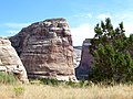
Steamboat Rock, south aspect
Highest point
Elevation 6,074 ft (1,851 m) [1]
Prominence 294 ft (90 m) [1]
Parent peak Jenny Lind Rock [1]
Isolation 0.9 mi (1.4 km) [1]
Coordinates 40°32′06″N108°59′12″W / 40.5349638°N 108.9867849°W / 40.5349638; -108.9867849 Coordinates: 40°32′06″N108°59′12″W / 40.5349638°N 108.9867849°W / 40.5349638; -108.9867849 [2]
Geography
USA Colorado relief location map.svg
Red triangle with thick white border.svg
Steamboat Rock
Location in Colorado
Usa edcp relief location map.png
Red triangle with thick white border.svg
Steamboat Rock
Steamboat Rock (the United States)
Location Dinosaur National Monument
Moffat County, Colorado, US
Parent range Uinta Mountains
Topo map USGS Canyon of Lodore South
Geology
Age of rock Permian-Pennsylvanian
Type of rock Weber Sandstone
Climbing
Easiest route class 5+ climbing [1]

Steamboat Rock, reaching an elevation of 6,074 ft (1,851 m) is a promontory located in the eastern Uinta Mountains, in Moffat County of northwest Colorado, United States. [2] This iconic landmark of Dinosaur National Monument is situated at the confluence of the Green River and Yampa River. Precipitation runoff from this feature drains into the Green River. This geographical formation was originally named "Echo Rock" in John Wesley Powell's 1875 report, The Exploration of the Colorado River and Its Canyons . The Steamboat name first appeared on a 1941 United States Geological Survey map of Dinosaur National Monument. [2] The area around it still retains the Echo Park name applied by Powell during the Powell Geographic Expedition of 1869.

Contents

Geology

Steamboat Rock is a mile-long, 1,000-ft high, slender peninsular ridge within a meander of the Green River. It is composed almost entirely of Permian-Pennsylvanian Weber Sandstone, with a thin layer of Park City Formation caprock. [3] It is located where the river exits Lodore Canyon and enters Echo Park. The river drops 15 feet as it courses around Steamboat Rock.

Climate

Spring and fall are the most favorable seasons to visit Steamboat Rock. According to the Köppen climate classification system, it is located in a semi-arid climate zone, with temperatures averaging between 0°F to 30°F in January, and 50°F to 100°F in July. [4] Typical of high deserts, summer temperatures can be exceedingly hot, while winter temperatures can be very cold. Snowfall is common, but the snow melts rapidly in the arid and sunny climate. Rainfall is very low, and the evaporation rate classifies the area as desert, even though the rainfall exceeds 10 inches.

Climate data for Dinosaur National Monument
MonthJanFebMarAprMayJunJulAugSepOctNovDecYear
Average high °F (°C)33.0
(0.6)
39.0
(3.9)
50.4
(10.2)
60.8
(16.0)
71.9
(22.2)
83.2
(28.4)
90.5
(32.5)
87.9
(31.1)
77.7
(25.4)
63.6
(17.6)
45.7
(7.6)
34.2
(1.2)
61.5
(16.4)
Average low °F (°C)10.8
(−11.8)
15.2
(−9.3)
25.0
(−3.9)
31.8
(−0.1)
40.5
(4.7)
48.9
(9.4)
56.6
(13.7)
54.7
(12.6)
45.5
(7.5)
34.9
(1.6)
23.3
(−4.8)
12.7
(−10.7)
33.3
(0.7)
Average precipitation inches (mm)0.64
(16)
0.56
(14)
0.88
(22)
1.17
(30)
1.30
(33)
1.06
(27)
1.01
(26)
0.89
(23)
1.24
(31)
1.46
(37)
0.80
(20)
0.62
(16)
11.64
(296)
Average snowfall inches (cm)9.2
(23)
6.6
(17)
5.9
(15)
3.5
(8.9)
0.7
(1.8)
0.2
(0.51)
0.0
(0.0)
0.0
(0.0)
0.2
(0.51)
1.6
(4.1)
4.7
(12)
8.3
(21)
41.1
(104)
Source: The Western Regional Climate Center [5]

Related Research Articles

<span class="mw-page-title-main">Canyonlands National Park</span> National park in Utah, United States

Canyonlands National Park is an American national park located in southeastern Utah near the town of Moab. The park preserves a colorful landscape eroded into numerous canyons, mesas, and buttes by the Colorado River, the Green River, and their respective tributaries. Legislation creating the park was signed into law by President Lyndon Johnson on September 12, 1964.

<span class="mw-page-title-main">Green River (Colorado River tributary)</span> River in Wyoming, Utah, and Colorado, United States

The Green River, located in the western United States, is the chief tributary of the Colorado River. The watershed of the river, known as the Green River Basin, covers parts of the U.S. states of Wyoming, Utah, and Colorado. The Green River is 730 miles (1,170 km) long, beginning in the Wind River Mountains of Wyoming and flowing through Wyoming and Utah for most of its course, except for a short segment of 40 miles (64 km) in western Colorado. Much of the route traverses the arid Colorado Plateau, where the river has carved some of the most spectacular canyons in the United States. The Green is slightly smaller than Colorado when the two rivers merge but typically carries a larger load of silt. The average yearly mean flow of the river at Green River, Utah is 6,121 cubic feet (173.3 m3) per second.

<span class="mw-page-title-main">Yampa River</span> River in Moffat and Routt counties in Colorado, United States

The Yampa River flows 250 miles (400 km) through northwestern Colorado in the United States. Rising in the Rocky Mountains, it is a tributary of the Green River and a major part of the Colorado River system. The Yampa is one of the few free-flowing rivers in the western United States, with only a few small dams and diversions.

<span class="mw-page-title-main">Dinosaur National Monument</span> National monument in Colorado and Utah, United States

Dinosaur National Monument is an American national monument located on the southeast flank of the Uinta Mountains on the border between Colorado and Utah at the confluence of the Green and Yampa rivers. Although most of the monument area is in Moffat County, Colorado, the Dinosaur Quarry is located in Utah, north of the town of Jensen, Utah. The nearest Colorado town is Dinosaur while the nearest city is Vernal, Utah.

<span class="mw-page-title-main">Gates of Lodore</span> Canyon entrance in Colorado

The Gates of Lodore is the scenic entrance to the Canyon of Lodore, a canyon on the Green River in northwestern Colorado, United States. The name Gates of Lodore has become synonymous with the canyon itself and the two names are used interchangeably. The Canyon commences as the Green River departs Browns Park and cuts through the Uinta Mountains meandering eighteen miles until its end at Echo Park (Colorado), the confluence of the Green and Yampa River. It was named by the Powell Expedition after the English poem Cataract of Lodore. It is located in Dinosaur National Monument.

<span class="mw-page-title-main">Echo Park (Moffat County, Colorado)</span> Valley in Moffat County, Colorado, United States

Echo Park is a remote river bottom surrounded by canyon walls on the Green River, just downstream from the confluence with the Yampa River and across the stream from the dramatic southern end of Steamboat Rock in Dinosaur National Monument.

<span class="mw-page-title-main">Echo Park Dam</span> Dam in Northwestern Colorado

Echo Park Dam was proposed in the 1950s by the U.S. Bureau of Reclamation as a central feature of the Colorado River Storage Project. Situated on the Green River, a major tributary of the Colorado River, the dam was proposed for the Echo Park district of Dinosaur National Monument, flooding much of the Green and Yampa river valleys in the monument. The dam was bitterly opposed by preservationists, who saw the encroachment of a dam into an existing national park as another Hetch Hetchy, to be opposed as an appropriation of protected lands for development purposes. The Echo Park project was abandoned in favor of Glen Canyon Dam on the main stem of the Colorado, in lands that were not at that time protected. This was eventually regarded as a strategic mistake by conservation organizations.

<span class="mw-page-title-main">Bridge Mountain (Utah)</span> Mountain in the United States

Bridge Mountain is a 6,803-foot (2,074 m) mountain made of Navajo Sandstone in Zion National Park in Washington County, of southwest Utah, United States.

<span class="mw-page-title-main">The East Temple</span>

The East Temple is a prominent 7,709 feet (2,350 m) summit composed of Navajo Sandstone in Zion National Park, in Washington County of southwest Utah, United States. It is one of the notable landmarks in the park. The nearest neighbor is Twin Brothers, one-half mile to the north, and the nearest higher peak is The West Temple, 3.85 miles (6.20 km) to the west-southwest. The mountain is situated 1.8 miles northeast of the park headquarters, at the confluence of Pine Creek and the North Fork Virgin River. This feature's name was applied by John Wesley Powell during his explorations in 1872, and was officially adopted in 1934 by the U.S. Board on Geographic Names. The first ascent was made in 1937 by Glen Dawson, Dick Jones, Homer Fuller, Wayland Gilbert, and Jo Momyer.

<span class="mw-page-title-main">The West Temple</span>

The West Temple is a prominent 7,810-foot mountain summit composed of Navajo Sandstone in Zion National Park in Washington County of Utah, United States. This, the highest feature in Zion Canyon, was originally called "Temp-o-i-tin-car-ur" meaning "Mountain without a trail" by the Paiute people. It was called Steamboat Mountain by local Mormon settlers before 1934, when the USGS officially changed it to its present name, which was applied by John Wesley Powell during his explorations in 1872. West Temple is situated two miles northwest of Springdale, Utah, one mile northeast of Mount Kinesava, and two miles west of the park headquarters. It is one of the notable landmarks in the park. The nearest higher peak is Windy Peak, 10.46 miles (16.83 km) to the north. Precipitation runoff from the mountain drains into tributaries of the Virgin River.

<span class="mw-page-title-main">Druid Arch</span>

Druid Arch is an iconic 150-foot tall Cedar Mesa Sandstone arch located within the Needles District of Canyonlands National Park, in San Juan County, Utah. It is situated at the head of Elephant Canyon, and precipitation runoff from Druid Arch drains north into the nearby Colorado River via Elephant Canyon. Druid Arch is one of the most popular hiking destinations in the Needles district. A 5.4 mile hike to Druid Arch starts at the Elephant Hill Trailhead, and the final quarter-mile is steep with some scrambling and one ladder. The name comes from its resemblance to the Stonehenge monument in England, which is believed to be a Druid temple. This feature's name was officially adopted in 1963 by the U.S. Board on Geographic Names.

<span class="mw-page-title-main">The Organ (Zion National Park)</span>

The Organ is a 5,080-foot (1,550 m) elevation Navajo Sandstone summit located in Zion National Park, in Washington County of southwest Utah, United States. The Organ is situated in the Big Bend at the north end of Zion Canyon, rising 700-feet above the canyon floor and the North Fork of the Virgin River which drains precipitation runoff from this rock. Neighbors include The Great White Throne, Cathedral Mountain, Angels Landing, Observation Point, and Cable Mountain. The Organ is believed to have been named by Claud Hirschi and Ethelbert Bingham, residents of Rockville, on their 1916 trip with Methodist Minister Frederick Vining Fisher, who also named geographical formations in Zion. This geographical feature's descriptive name was officially adopted in 1934 by the U.S. Board on Geographic Names.

<span class="mw-page-title-main">Washer Woman</span>

Washer Woman is a 500-foot (150-meter) tall sandstone arch and tower located in the Island in the Sky District of Canyonlands National Park, in San Juan County, Utah. It is situated 300 feet northwest of the slightly higher Monster Tower. Washer Woman is so named because the feature gives the appearance of a washerwoman bent over a washtub. This geographical feature's name was officially adopted in 1986 by the U.S. Board on Geographic Names after previously having similar names such as Washer-Woman Arch and The Washer Woman. Washer Woman and Monster Tower are an eroded fin composed of Wingate Sandstone, which is the remains of wind-borne sand dunes deposited approximately 200 million years ago in the Late Triassic. Airport Tower is set 1.6 mi (2.6 km) to the east, and Mesa Arch is situated 1.5 mi (2.4 km) to the west. A short hike to Mesa Arch provides the easiest view of Washer Woman. Access to this formation is via the four-wheel drive White Rim Road, which is the other option to see it. The top of this geological formation rises 1,300 feet above the road in approximately one mile. Precipitation runoff from Washer Woman drains southeast into the nearby Colorado River via Buck Canyon.

<span class="mw-page-title-main">Zeus and Moses</span> Rock formations in Utah, United States

Zeus and Moses are a pair of 500-foot-tall (150 m) sandstone formations located in the Island in the Sky District of Canyonlands National Park, in San Juan County, Utah, United States. These rock towers' names refer to Zeus, a god in Greek mythology, and Moses, an important prophet in several religious traditions. Zeus and Moses are composed of Wingate Sandstone, which is the remains of wind-borne sand dunes deposited approximately 200 million years ago in the Late Triassic. This formation is situated in Taylor Canyon, 3 mi (4.8 km) north-northeast of Upheaval Dome. Access to the towers is via the four-wheel-drive White Rim Road, and a spur road into Taylor Canyon. The top of this geological formation rises 900 feet above the canyon floor at road's end, approximately one-half mile away. Precipitation runoff from Zeus and Moses drains into the nearby Green River via Taylor Canyon.

<span class="mw-page-title-main">Beatty Point (Utah)</span>

Beatty Point is a 7,780-foot (2,370 m) elevation summit located in the Kolob Canyons area of Zion National Park in Washington County, Utah, United States.

<span class="mw-page-title-main">Buttes of the Cross</span>

Buttes of the Cross is two sandstone summits located in the northern reach of Glen Canyon National Recreation Area, in Wayne County of Utah, United States. The larger and higher south butte reaches an elevation of 5,642 feet, whereas the north butte rises to 5,569 feet, with approximately 0.6 mile separation between them. When viewed from the north-northeast near Labyrinth Canyon, they align to form the shape of a cross, creating the appearance of a single butte. The name "Butte of the Cross" was first applied by John Wesley Powell during the Powell Geographic Expedition of 1869. A few miles further down the Green River, Powell finds that this geographical feature is two buttes when viewed from the east, so it was renamed Buttes of the Cross. Buttes of the Cross towers over 1,400 feet above its surrounding terrain. It is situated 6.8 miles west of Candlestick Tower, and one-half mile outside the boundary of Canyonlands National Park.

<span class="mw-page-title-main">Steamboat Mountain (Coconino County, Arizona)</span> Landform in the Grand Canyon, Arizona

Steamboat Mountain is a 7,410-foot-elevation (2,260 meter) summit located in the Grand Canyon, in Coconino County of northern Arizona, US. It is situated four miles northwest of Holy Grail Temple, and 2.5 miles west-southwest of Timp Point on the North Rim. George Wharton James described it as a "majestic butte", nearly encircled by Galloway and Saddle Canyons. Topographic relief is significant as it rises over 5,400 feet (1,645 meters) above the Colorado River in three miles. According to the Köppen climate classification system, Steamboat Mountain is located in a Cold semi-arid climate zone, with precipitation runoff draining west to the Colorado River via Tapeats Creek and Stone Creek. This feature's name was officially adopted in 1932 by the U.S. Board on Geographic Names.

<span class="mw-page-title-main">Sentinel Spire</span>

Sentinel Spire is a 5,500-foot-elevation (1,700-meter) sandstone pillar located in Colorado National Monument, in Mesa County of western Colorado, United States. This 200-foot freestanding tower is situated in Wedding Canyon, one-half mile east of the monument's visitor center, and 9 miles (14 km) west of the community of Grand Junction. It is also immediately south of Window Rock, and north of another climbing destination, Pipe Organ, both of which can be seen from viewpoints along Rim Rock Drive. The first ascent of the summit was made May 3, 1960, by Layton Kor, Harvey Carter, and John Auld via the class 5.10 route, Fast Draw. This was the day before the climbers also made the first ascent of nearby Kissing Couple. The first solo ascent was made by Ron Olevsky in March 1976, and the first free ascent was made by Andy Petefish and John Christenson in 1978. Some climbers refer to Sentinel Spire as Watusi Spear.

<span class="mw-page-title-main">Grand View Spire</span>

Grand View Spire is a 5,821-foot-elevation (1,774-meter) sandstone pillar located in Colorado National Monument, in Mesa County of western Colorado, United States. This 400-foot tower is situated on the west side of Monument Canyon, one mile southeast of the monument's visitor center, and 9 miles (14 km) west of the community of Grand Junction. It is also 0.32 mile immediately south of Independence Monument, and 0.27 mile northwest of another climbing destination, Kissing Couple. Its unofficial name relates to its position at the tip of Grand View Overlook, one of several scenic viewpoints along Rim Rock Drive.

<span class="mw-page-title-main">Coke Ovens (Colorado National Monument)</span>

Coke Ovens is a 5,962-foot-elevation (1,817-meter) linear set of pillars located in Colorado National Monument, in Mesa County of western Colorado, United States. This iconic landmark is situated on the west side of Monument Canyon, two miles south of the monument's visitor center, and 9 miles (14 km) west of the community of Grand Junction. It is also one mile south of Kissing Couple, and both can be seen from viewpoints along Rim Rock Drive. It is so named because the rounded shape resembles beehive coke ovens that were used in the nineteenth century to convert bituminous coal into coke, which was then used for smelting iron.

References

  1. 1 2 3 4 5 "Steamboat Rock - 6,074' CO". listsofjohn.com. Retrieved 2020-10-02.
  2. 1 2 3 U.S. Geological Survey Geographic Names Information System: Steamboat Rock
  3. H. E. Thomas, Hydrologic Reconnaissance of the Green River in Utah and Colorado, US Department of the Interior, 1962, page 10.
  4. Weather Dinosaur National Monument. National Park Service.gov
  5. "Seasonal Temperature and Precipitation Information". Western Regional Climate Center. Retrieved May 3, 2013.