
Bonneville Lock and Dam consists of several run-of-the-river dam structures that together complete a span of the Columbia River between the U.S. states of Oregon and Washington at River Mile 146.1. The dam is located 40 miles (64 km) east of Portland, Oregon, in the Columbia River Gorge. The primary functions of Bonneville Lock and Dam are electrical power generation and river navigation. The dam was built and is managed by the United States Army Corps of Engineers. At the time of its construction in the 1930s it was the largest water impoundment project of its type in the nation, able to withstand flooding on an unprecedented scale. Electrical power generated at Bonneville is distributed by the Bonneville Power Administration. Bonneville Lock and Dam is named for Army Capt. Benjamin Bonneville, an early explorer credited with charting much of the Oregon Trail. The Bonneville Dam Historic District was designated a National Historic Landmark District in 1987.

The Housatonic River is a river, approximately 149 miles (240 km) long, in western Massachusetts and western Connecticut in the United States. It flows south to southeast, and drains about 1,950 square miles (5,100 km2) of southwestern Connecticut into Long Island Sound. Its watershed is just to the west of the watershed of the lower Connecticut River.

Davis Dam is a dam on the Colorado River about 70 miles (110 km) downstream from Hoover Dam. It stretches across the border between Arizona and Nevada. Originally called Bullhead Dam, Davis Dam was renamed after Arthur Powell Davis, who was the director of the U.S. Bureau of Reclamation from 1914 to 1923. The United States Bureau of Reclamation owns and operates the dam, which was completed in 1951.

This is intended to be a complete list of the properties and districts on the National Register of Historic Places in Fairfield County, Connecticut, United States. The locations of National Register properties and districts for which the latitude and longitude coordinates are included below may be seen in an online map.

Folsom Powerhouse State Historic Park is a historical site preserving an 1895 alternating current (AC) hydroelectric power station—one of the first in the United States.

The Robert Moses Niagara Hydroelectric Power Station is a hydroelectric power station in Lewiston, New York, near Niagara Falls. Owned and operated by the New York Power Authority (NYPA), the plant diverts water from the Niagara River above Niagara Falls and returns the water into the lower portion of the river near Lake Ontario. It uses 13 generators at an installed capacity of 2,525 MW (3,386,000 hp).

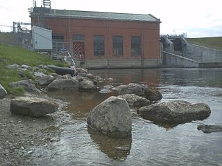
Lock and Dam No. 19 is a lock and dam located on the Upper Mississippi River near Keokuk, Iowa. In 2004, the facility was listed in the National Register of Historic Places as Lock and Dam No. 19 Historic District, #04000179 covering 1,605 acres (650 ha), 7 buildings, 12 structures, 1 object. The lock is owned and operated by the U.S. Army Corps of Engineers. The dam is owned and operated by Ameren Missouri.
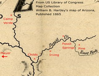
Childs-Irving Hydroelectric Facilities consisted of two 20th-century power plants, a dam, and related infrastructure along or near Fossil Creek in the U.S. state of Arizona. The complex was named an Historic Mechanical Engineering Landmark in 1971 and was added to the National Register of Historic Places 20 years later. Decommissioned in 2005, the plants no longer produce electricity, and much of the infrastructure—including the dam, the Irving Power Plant, and thousands of feet of concrete flumes—have been removed, and the creek's original flow has been restored.

Milner Dam is a rockfill dam near Burley in south central Idaho. It impounds the Snake River in a reservoir named Milner Lake. The dam spans the river across two islands, with three embankments.

Croton Dam is an earth-filled embankment dam and powerplant complex on the Muskegon River in Croton Township, Newaygo County, Michigan. It was built in 1907 under the direction of William D. Fargo by the Grand Rapids - Muskegon Power Company, a predecessor of Consumers Energy. The 40-foot-high (12 m) dam impounds 7.2 billion U.S. gallons (6 billion imp. gal/27 billion L) of water in its 1,209-acre (489 ha) reservoir and is capable of producing 8,850 kilowatts at peak outflow. It was listed on the National Register of Historic Places in 1979.

The Glendale Power House is a historic power station on the Housatonic River, just off Massachusetts Route 183 in Stockbridge, Massachusetts. The 1905 power house, built for the Monument Mills, was the one of the first places in the United States where electricity was generated for the purpose of providing power to an industrial facility. The station was listed on the National Register of Historic Places in 1982. The facility has been rehabilitated and converted into modernized hydroelectric power generation plant.

Hardy Dam is an earth-filled embankment dam and powerplant complex on the Muskegon River in Big Prairie Township, Newaygo County, Michigan. At the time of its completion, it was the largest earthen dam in North America east of the Mississippi. Its impoundment forms a lake with over 50 miles of shoreline. The dam impounds a reservoir with a surface area of 4,000 acres and its power plant has an installed capacity of 31.5 MW.

The Stevenson Dam Bridge carries Connecticut Route 34 over the Housatonic River in the U.S. state of Connecticut, connecting the town of Monroe to the town of Oxford.

The Occum Hydroelectric Plant and Dam is a historic hydroelectric plant and dam north of Bridge Street on the west side of the Shetucket River in Norwich, Connecticut. The facility includes a rare surviving partial example of a large-scale dam built for a textile mill in 1865, and an early example of a hydroelectric power generation facility established in 1934. It is one of a small number of surviving hydroelectric plants in the state which was built before 1940. The complex was listed on the National Register of Historic Places in 1996.

Morony Dam is a hydroelectric gravity dam located on the Missouri River in Cascade County, Montana. The dam is 883 feet (269 m) long and 94 feet (29 m) high, and generates 49 megawatts (MW) of power.

Stave Falls Dam is a dual-dam power complex on the Stave River in Stave Falls, British Columbia, Canada. The dam was completed in 1912 for the primary purpose of hydroelectric power production. To increase the capacity of Stave Lake, the dam was raised in 1925 and the Blind Slough Dam constructed in an adjacent watercourse 500 m (1,600 ft) to the north, which was the site of the eponymous Stave Falls. In 2000, the dam's powerhouse was replaced after a four-year upgrade. The powerhouse was once British Columbia's largest hydroelectric power source and is a National Historic Site of Canada.
Cooke Dam is a hydro-electric dam on the Au Sable River in Michigan. It was listed on the National Register of Historic Places in 1996 as the Cooke Hydroelectric Plant.

The Devil's Gate-Weber Hydroelectric Power Plant was built in 1909–1910 on the Weber River in northeastern Utah, United States, about 10 miles (16 km) southeast of Ogden. It was built by the Utah Light and Railway Company under the direction of E.H. Harriman, a director of the Union Pacific Railroad. It was one of the first powerplants in Utah designed to feed an electrical grid rather than as a source of power of a single locality.

The Stairs Station Hydroelectric Power Plant was built in 1894-1895 in Big Cottonwood Canyon, about 8 miles (13 km) southeast of Salt Lake City, Utah. The plant comprises the powerhouse, switchyard, penstocks, and a pipeline. A dam next to the site is associated with the Granite Power Plant farther downstream, and is part of neither historic district. The powerhouse is the only remaining building associated with the plant. It is an example of an intact high-head generating plant from the late 19th century.
The Granite Hydroelectric Power Station was built in 1896–1897 at the mouth of Big Cottonwood Canyon, about 6 miles (9.7 km) southeast of Salt Lake City, Utah, United States(in what is now eastern Cottonwood Heights. The plant comprises the powerhouse, transformer house, a wooden conduit, penstocks, and a small dam. Like the Stairs Station upstream, it represents an intact high-head generating plant from the late 19th century.


