Whitewater State Park is a state park of Minnesota, United States, preserving a stretch of the Whitewater River surrounded by rocky bluffs. It is located in Winona County in the southeastern blufflands area of the state. The 2,700-acre (11 km2) park features scenic overlooks and trout fishing in the spring-fed Whitewater River and Trout Run Creek. It has about 300,000 visitors annually, and is located 7 miles (11 km) north of St. Charles on Minnesota State Highway 74, which runs through the park.

The Stillwater Bridge is a vertical-lift bridge crossing the St. Croix River between Stillwater, Minnesota, and Houlton, Wisconsin. It formerly connected Minnesota State Highway 36 and Wisconsin Highway 64. Around 18,000 vehicles crossed the bridge daily. The new St. Croix Crossing bridge crossing the St. Croix river valley to the south of Stillwater replaced its purpose, having opened to highway traffic on August 2, 2017, leaving the Stillwater Lift Bridge to be preserved and to be converted to bicycle/pedestrian use.

Cascade River State Park is a state park near the northeastern tip of Minnesota, US. The park is in a rocky and rugged location where the Cascade River descends to meet Lake Superior. It has many different types of wildlife including various birds and mammals.

Interstate Park comprises two adjacent state parks on the Minnesota–Wisconsin border, both named Interstate State Park. They straddle the Dalles of the St. Croix River, a deep basalt gorge with glacial potholes and other rock formations. The Wisconsin park is 1,330 acres (538 ha) and the Minnesota park is 298 acres (121 ha). The towns of Taylors Falls, Minnesota and St. Croix Falls, Wisconsin are adjacent to the park. Interstate Park is within the Saint Croix National Scenic Riverway and the Ice Age National Scientific Reserve. The western terminus of the Ice Age National Scenic Trail is on the Wisconsin side. On the Minnesota side, two areas contain National Park Service rustic style buildings and structures that are listed on the National Register of Historic Places.

The St. Croix Boom Site is a historic and scenic wayside on the St. Croix River in Stillwater Township, Minnesota, United States. It commemorates the location of a critical log boom where, from 1856 to 1914, timber from upriver was sorted and stored before being dispatched to sawmills downstream. The site was developed as a roadside park along Minnesota State Highway 95 in the 1930s. In 1966 it was designated a National Historic Landmark for its national significance in the theme of industry. It was nominated for being the earliest, most important, and longest serving of the log storage and handling operations that supported Minnesota's major logging industry. Virtually no traces remain of the site's original buildings and structures.
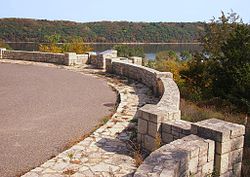
Preston Overlook is a historic scenic overlook in Preston, Minnesota, United States, North America.

Bridge 5757 or the Fond du Lac Culvert is a historic bridge in the Fond du Lac neighborhood of Duluth, Minnesota, United States. It was built in 1937 to carry Minnesota State Highway 23 over Mission Creek. It is a double-span culvert built using a modular, corrugated iron product called "multi-plate", with granite headwalls. The creek flows through two 20-foot (6 m) metal culverts that are 115 feet (35 m) wide. The bridge was part of a 0.75-mile (1.2 km) section of Highway 23 built as a wide, shaded, parkway-like divided highway known as Veterans' Evergreen Memorial Highway.

The Moritz Bergstein Shoddy Mill and Warehouse are two historic industrial buildings in Stillwater, Minnesota, United States, in which Jewish German immigrant Moritz Bergstein conducted a recycling business circa 1890 to 1910 providing materials for mattresses. They were originally built in Oak Park Heights, Minnesota, around 1890 and were moved to neighboring Stillwater in 2012 to make way for construction of the St. Croix Crossing bridge. The property was listed on the National Register of Historic Places in 2008 for its local significance in the themes of industry and social history. It was nominated as a rare surviving embodiment of Minnesota's early Jewish immigrants and their frequent participation in the waste materials trade.
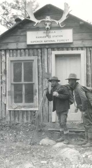
The Isabella Ranger Station is a complex of 21 buildings in Stony River Township, Minnesota, United States, near the town of Isabella. It is located on Minnesota State Highway 1 about one mile east of Isabella. The complex is listed on the National Register of Historic Places for its association with New Deal federal relief construction.
Arthur R. Nichols was a landscape architect who practiced in New York City and Minnesota in a long career from 1902 through 1960. He was a very productive landscape architect who was instrumental in bringing the field of landscape architecture to Minnesota.

The Craigie Flour Mill Historical Marker is a wayside rest on Minnesota State Highway 78 in Otter Tail County, Minnesota. The site was designed by landscape architect Arthur R. Nichols and built by the National Youth Administration and the Minnesota Highway Department. The style is National Park Service Rustic architecture.
Isaac Staples' Sawmill is a historic industrial property in Stillwater, Minnesota, United States, consisting of an 1850 stone powerhouse and a 1900 metal-clad factory. The property was listed on the National Register of Historic Places as St. Croix Lumber Mills—Stillwater Manufacturing Company in 1982 for its local significance in the theme of industry. It was nominated because the powerhouse is the only surviving industrial building associated with Isaac Staples (1816–1898), a major figure in Minnesota's early commercial development. The property now operates as a shopping mall with upper level apartments.

Pine-Hickory Lakes Roadside Parking Area is a wayside rest located along U.S. Highway 169 in Farm Island Township, Aitkin County, Minnesota. It straddles both sides of the highway just north of where it passes between Little Pine Lake on the west and Hickory Lake on the east. It is one of the largest wayside rests developed by the Minnesota Highway Department during the New Deal, at 35 acres (14 ha). Arthur R. Nichols, collaborating with engineer Harold E. Olson, designed the rest area in the National Park Service rustic style. The wayside rest was listed on the National Register of Historic Places in May 2016.

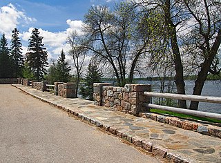
The St. Alban's Bay Culvert is a historic bridge in Garrison Township, Minnesota, United States. It carries the four-lane U.S. Route 169 (US 169) over the head of a stream flowing out of Mille Lacs Lake. It was built from 1938 to 1939 as part of a major New Deal project to create a scenic parkway along the lakeshore. The bridge was listed on the National Register of Historic Places in 2015 as the St. Alban's Bay Culvert at Mille Lacs Lake for having state-level significance in the themes of architecture and politics/government. It was nominated for being a well-preserved example of the Minnesota Highway Department's earliest scenic improvements, its rare status as a highway bridge built by the department's Roadside Development Division—a unit usually focused on overlooks and waysides—and for its fine National Park Service rustic design.
The Kenney Lake Overlook is a historic roadside park in Garrison Township, Minnesota, United States. Adjacent to the southbound lane of Minnesota State Highway 18 (MN 18), the two-acre (0.8 ha) site provides a parking area and an overlook of a small lake. The wayside was built in 1939 as part of a major New Deal project to create a scenic parkway along the shore of nearby Mille Lacs Lake. The Mille Lacs Highway Development Plan was the largest highway improvement project in the state constructed by the Civilian Conservation Corps (CCC). The Kenney Lake Overlook was listed on the National Register of Historic Places in 2015 for having state-level significance in the themes of landscape architecture and politics/government. It was nominated for being a key component of a major highway improvement project, for representing the work of the Veterans Division of the CCC and the earliest scenic improvements of the Minnesota Highway Department (MHD), and for its fine National Park Service rustic design.

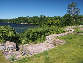
The Garrison Concourse is a roadside park on Mille Lacs Lake in Garrison, Minnesota, United States. The site consists of a wide parking area and scenic overlook projecting out into the lake, plus landscaped parkland along the shore in both directions. It was built from 1936 to 1939 as the centerpiece of the Mille Lacs Highway Development Plan, a major New Deal project to create a scenic parkway along the lakeshore. The park was listed on the National Register of Historic Places in 2013 for having state-level significance in the themes of landscape architecture and politics/government. It was nominated for being the premiere structure of the most extensive roadside development project undertaken by the Minnesota Highway Department and the Civilian Conservation Corps, and for its blend of formalism and National Park Service rustic design.

Parker's Woods is a recreational park located in Mason City, Iowa, United States. It was listed as a historic district on the National Register of Historic Places in 2014. At the time of its nomination it contained three resources, which included one contributing building, one contributing site, and one structure. It contains 13 acres (5.3 ha) of land along Willow Creek. The park features picnic areas, three tennis courts, volleyball court, basketball courts, playgrounds, and fishing in Willow Creek.

The Reads Landing Overlook is a scenic overlook on U.S. Route 61 in Pepin Township, Minnesota, United States. It was built from 1939 to 1940 as a New Deal project to provide motorists with a scenic view of Lake Pepin. It was designed by landscape architect Arthur R. Nichols and constructed by the National Youth Administration. The overlook was listed on the National Register of Historic Places in 2004 for its state-level significance in the themes of landscape architecture and politics/government. It was nominated for exemplifying the early highway waysides built in Minnesota with federal work relief aid, and for exemplifying as well National Park Service rustic style and the work of Nichols.
The Orr Roadside Parking Area is a roadside park on U.S. Route 53 in Orr, Minnesota, United States. It was built from 1935 to 1938 as a New Deal project to provide motorists with recreational access to Pelican Lake. It was designed by landscape architect Arthur R. Nichols and constructed by the Civilian Conservation Corps in collaboration with the Minnesota Department of Highways. The overlook was listed on the National Register of Historic Places in 2002 for its state-level significance in the themes of landscape architecture and politics/government. It was nominated for exemplifying the early highway waysides built in Minnesota with federal work relief aid, and for exemplifying National Park Service rustic style and the work of Nichols.

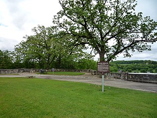
Inspiration Point Wayside Rest is a state highway wayside rest located along Minnesota State Highway 16 southwest of Lanesboro, Fillmore County, Minnesota. Minnesotan architect Arthur R. Nichols designed the wayside and it was built between 1934 and 1937 by the Minnesota Department of Transportation (MnDOT) and the Civilian Conservation Corps. In 2015, Inspiration Point Wayside Rest was listed on the National Register of Historic Places as a well-preserved example of the National Park Service rustic architectural style with good historic integrity, and the only surviving Minnesota wayside to have been built by a CCC soil erosion control camp. Major renovation work was undertaken that same year to restore degrading masonry and clear invasive buckthorn that had blocked several of the wayside's viewpoints.