Oak Park Heights, Minnesota

Last updated
Oak Park Heights
Motto: 
"Tree City USA"
Washington County Minnesota Incorporated and Unincorporated areas Oak Park Heights Highlighted.svg
Location of the city of Oak Park Heights
within Washington County, Minnesota
Coordinates: 45°2′6″N92°48′38″W / 45.03500°N 92.81056°W / 45.03500; -92.81056
CountryUnited States
State Minnesota
County Washington
Founded1857
Area
[1]
  Total3.35 sq mi (8.66 km2)
  Land2.93 sq mi (7.58 km2)
  Water0.42 sq mi (1.09 km2)
Elevation
784 ft (239 m)
Population
 (2020) [2]
  Total4,849
  Estimate 
(2021) [3]
4,750
  Density1,657.21/sq mi (639.89/km2)
Time zone UTC-6 (CST)
  Summer (DST) UTC-5 (CDT)
ZIP code
55082
Area code 651
FIPS code 27-47914
GNIS feature ID0648850 [4]
Website cityofoakparkheights.com

Oak Park Heights is a city in Washington County, Minnesota, United States. The population was 4,849 at the 2020 census. [2]

Contents

History

Formerly called simply Oak Park, the city was platted in 1857. [5] [6] The 1932 Log Cabin restaurant and 1939 Stillwater Overlook are listed on the National Register of Historic Places. [7]

Geography

According to the United States Census Bureau, the city has a total area of 3.03 square miles (7.85 km2); 2.98 square miles (7.72 km2) is land and 0.05 square miles (0.13 km2) is water. [8]

Oak Park Heights is located adjacent to the city of Stillwater. Minnesota State Highways 5, 36 and 95 are three of the main routes in the community.

Demographics

Historical population
CensusPop.
1960 332
1970 1,238272.9%
1980 2,591109.3%
1990 3,48634.5%
2000 3,95713.5%
2010 4,3399.7%
2020 4,84911.8%
2021 (est.)4,750 [3] −2.0%
U.S. Decennial Census [9]
2020 Census [2]

2010 census

As of the census of 2010, there were 4,339 people, 1,842 households, and 980 families living in the city. The population density was 1,456.0 inhabitants per square mile (562.2/km2). There were 2,039 housing units at an average density of 684.2 per square mile (264.2/km2). The racial makeup of the city was 89.8% White, 4.5% African American, 1.6% Native American, 2.0% Asian, 0.5% from other races, and 1.5% from two or more races. Hispanic or Latino of any race were 3.0% of the population.

There were 1,842 households, of which 23.1% had children under the age of 18 living with them, 40.7% were married couples living together, 8.5% had a female householder with no husband present, 4.1% had a male householder with no wife present, and 46.8% were non-families. 42.6% of all households were made up of individuals, and 24.4% had someone living alone who was 65 years of age or older. The average household size was 2.06 and the average family size was 2.83.

The median age in the city was 44.9 years. 17.8% of residents were under the age of 18; 8% were between the ages of 18 and 24; 24.3% were from 25 to 44; 27% were from 45 to 64; and 23% were 65 years of age or older. The gender makeup of the city was 52.1% male and 47.9% female.

2000 census

As of the census of 2000, there were 3,957 people, 1,528 households, and 921 families living in the city. The population density was 1,313.6 inhabitants per square mile (507.2/km2). There were 1,581 housing units at an average density of 524.8 per square mile (202.6/km2). The racial makeup of the city was 91.03% White, 4.42% African American, 0.91% Native American, 1.29% Asian, 0.03% Pacific Islander, 0.63% from other races, and 1.69% from two or more races. Hispanic or Latino of any race were 2.10% of the population.

There were 1,528 households, out of which 30.6% had children under the age of 18 living with them, 45.7% were married couples living together, 10.1% had a female householder with no husband present, and 39.7% were non-families. 34.8% of all households were made up of individuals, and 16.2% had someone living alone who was 65 years of age or older. The average household size was 2.26 and the average family size was 2.94.

In the city, the population was spread out, with 21.8% under the age of 18, 9.1% from 18 to 24, 34.4% from 25 to 44, 21.8% from 45 to 64, and 12.8% who were 65 years of age or older. The median age was 36 years. For every 100 females, there were 117.5 males. For every 100 females age 18 and over, there were 119.3 males.

The median income for a household in the city was $48,425, and the median income for a family was $69,485. Males had a median income of $46,558 versus $30,788 for females. The per capita income for the city was $23,293. About 2.1% of families and 3.4% of the population were below the poverty line, including 2.9% of those under age 18 and 6.2% of those age 65 or over.

Related Research Articles

<span class="mw-page-title-main">Charter Oak, Iowa</span> City in Iowa, United States

Charter Oak is a city in Crawford County, Iowa, United States, along the East Soldier River. The population was 535 at the 2020 census.

<span class="mw-page-title-main">Tiffin, Iowa</span> City in Iowa, United States

Tiffin is a city in Johnson County, Iowa, United States. It is part of the Iowa City, Iowa Metropolitan Statistical Area. The population was 4,512 at the time of the 2020 census. F. W. Kent County Park is located just to the west of Tiffin, and is a popular site for outdoor recreation in Johnson County, being noted for its lake, camping facilities, resident whitetail deer herd and wild turkeys, and its cross-country ski trails through rolling acres of oak and hickory forest.

<span class="mw-page-title-main">Palo, Iowa</span> City in Iowa, United States

Palo is a city in Linn County, Iowa, United States. The population was 1,407 at the time of the 2020 census. It is part of the Cedar Rapids Metropolitan Statistical Area.

Alton is a town in Penobscot County, Maine, United States. It is part of the Bangor Metropolitan Statistical Area. The population was 829 at the 2020 census. The community is named after an Alton in England.

<span class="mw-page-title-main">Andover, Minnesota</span> City in Minnesota, United States

Andover is a city in Anoka County, Minnesota, United States. The population was 32,601 at the 2020 census.

<span class="mw-page-title-main">East Bethel, Minnesota</span> City in Minnesota, United States

East Bethel is a city in Anoka County, Minnesota, United States. The population was 11,786 at the 2020 census.

<span class="mw-page-title-main">Oak Grove, Minnesota</span> City in Minnesota, United States

Oak Grove is a city in Anoka County, Minnesota, United States. It is north of Minneapolis. The population was 8,031 at the 2010 census.

<span class="mw-page-title-main">Ramsey, Minnesota</span> City in Minnesota, United States

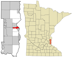
Ramsey is a suburb 22 miles (35 km) north-northwest of downtown Minneapolis in Anoka County, Minnesota, United States. The population was 23,668 at the 2010 census. It is a northwest suburb of the Twin Cities.

<span class="mw-page-title-main">Watertown, Minnesota</span> City in Minnesota, United States

Watertown is a small city in Carver County, Minnesota, United States, along the South Fork of the Crow River. The population was 4,659 at the 2020 census.

<span class="mw-page-title-main">Garfield, Minnesota</span> City in Minnesota, United States

Garfield is a city in Douglas County, Minnesota, United States. The population was 349 at the 2020 census.

<span class="mw-page-title-main">Bluffton, Minnesota</span> City in Minnesota, United States

Bluffton is a city in Otter Tail County, Minnesota, United States, along the Leaf River. The population was 210 at the 2020 census.

<span class="mw-page-title-main">McIntosh, Minnesota</span> City in Minnesota, United States

McIntosh is a city in Polk County, Minnesota, United States. It is part of the Grand Forks, ND-MN Metropolitan Statistical Area. The population was 606 at the 2020 census.

<span class="mw-page-title-main">Mentor, Minnesota</span> City in Minnesota, United States

Mentor is a city in Polk County, Minnesota, United States. It is part of the Grand Forks-ND-MN Metropolitan Statistical Area. The population was 104 at the 2020 census. The city is near Maple Lake.

Oak Township is a township in Stearns County, Minnesota, United States. The population was 595 at the 2010 census. The township includes the cities of Freeport and New Munich.

<span class="mw-page-title-main">Selby, South Dakota</span> City in South Dakota, United States

Selby is a city in Walworth County, South Dakota, United States. The population was 610 at the 2020 census. It is the county seat of Walworth County.

<span class="mw-page-title-main">St. Anthony, Stearns County, Minnesota</span> City in Minnesota, United States

St. Anthony is a city in Stearns County, Minnesota, United States. The population was 86 at the 2010 census. It is part of the St. Cloud Metropolitan Statistical Area. Main routes include Minnesota State Highway 238, Stearns County Road 153, and Trobec Street.

<span class="mw-page-title-main">Oak Hill, West Virginia</span> City in West Virginia, United States

Oak Hill is a city in Fayette County, West Virginia, United States. The population was 8,179 at the 2020 census. It is part of the Beckley metropolitan area. The city is also home to the historic Oak Hill Railroad Depot which still stands today as an artisan shop. Country singer Hank Williams died in Oak Hill on his way to a concert on January 1, 1953. More recently, recreation has become a leading industry as the city neighbors the New River Gorge National Park and Preserve.

<span class="mw-page-title-main">Browntown, Wisconsin</span> Village in Wisconsin, United States

Browntown is a village in Green County, Wisconsin, United States. The population was 280 at the 2010 census.

<span class="mw-page-title-main">Prescott, Wisconsin</span> City in Wisconsin, United States

Prescott is a city in Pierce County, Wisconsin at the confluence of the St. Croix River and Mississippi River. The population was 4,258 at the 2010 census, making it the second-largest city in the county after River Falls, and the largest entirely within Pierce County.

<span class="mw-page-title-main">Minnesota Lake, Minnesota</span> City in Minnesota, United States

Minnesota Lake is a city in Blue Earth and Faribault counties in the State of Minnesota. The population was 661 at the 2020 census. The bulk of the city is in Faribault County; a small part extends into Blue Earth County.

References

  1. "2020 U.S. Gazetteer Files". United States Census Bureau. Retrieved July 24, 2022.
  2. 1 2 3 "Explore Census Data". United States Census Bureau . Retrieved June 17, 2022.
  3. 1 2 "City and Town Population Totals: 2020-2021". United States Census Bureau. June 16, 2022. Retrieved June 17, 2022.
  4. "US Board on Geographic Names". United States Geological Survey. October 25, 2007. Retrieved January 31, 2008.
  5. "History of the City". City of Oak Park Heights, MN. Retrieved August 14, 2015.
  6. Upham, Warren (1920). Minnesota Geographic Names: Their Origin and Historic Significance. Minnesota Historical Society. p.  570.
  7. "National Register Information System". National Register of Historic Places . National Park Service. July 9, 2010.
  8. "US Gazetteer files 2010". United States Census Bureau. Archived from the original on January 12, 2012. Retrieved November 13, 2012.
  9. United States Census Bureau. "Census of Population and Housing" . Retrieved June 9, 2014.

Coordinates: 45°01′53″N92°47′35″W / 45.03139°N 92.79306°W / 45.03139; -92.79306