
Washington County is a county in the U.S. state of Minnesota. As of the 2010 United States Census, the population was 238,136, making it the fifth-most populous county in Minnesota. Its county seat is Stillwater. The largest city in the county is Woodbury, which had a population of 61,961 at the 2010 census.

Ramsey County is a county located in the U.S. state of Minnesota. As of the 2010 census, the population was 508,640, making it the second-most populous county in Minnesota. Its county seat and largest city is St. Paul, the state capital. The county was founded in 1849 and is named for Alexander Ramsey (W), the first governor of the Minnesota Territory.

Dakota County is the third-most populous county in the U.S. state of Minnesota. As of the 2010 United States Census, the population was 398,552. The county seat is Hastings. Dakota County is named for the Dakota Sioux tribal bands who inhabited the area. The name is recorded as "Dahkotah" in the United States Census records until 1851. Dakota County is included in the Minneapolis–St. Paul–Bloomington, MN–WI Metropolitan Statistical Area, the sixteenth largest metropolitan area in the United States with about 3.3 million residents. The county is bordered by the Minnesota and Mississippi Rivers on the north, and the state of Wisconsin on the east.
Anoka County is the fourth-most-populous county in the U.S. state of Minnesota. As of the 2010 United States census, the population was 339,534. The county seat and namesake of the county is the City of Anoka, which is derived from the Dakota word anokatanhan meaning "on both sides," referring to its location on the banks of the Rum River. The largest city in the county is the City of Blaine, the thirteenth-largest city in Minnesota and the seventh-largest Twin Cities suburb.

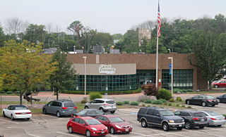
Baytown Township is an urban township in Washington County, Minnesota, United States. The population was 1,533 at the 2000 census. The unincorporated community of Siegel is located within Baytown Township.

Baytown is a city within Harris County and partially in Chambers County in the Gulf Coast region of the U.S. state of Texas. Located within the Houston–The Woodlands–Sugar Land metropolitan area, it lies on the northern side of the Galveston Bay complex near the outlets of the San Jacinto River and Buffalo Bayou. It is the sixth-largest city within this metropolitan area. Major highways serving the city include State Highway 146 and Interstate 10. As of 2010, Baytown had a population of 71,802, and it had an estimated population of 77,024 in 2018.

Colerain Township is one of the twelve townships of Hamilton County, Ohio, United States, and home of the Crazed Pickles. The population of the township was 58,499 at the 2010 census. It is the second-largest township in Ohio by population to West Chester Twp., Butler County, Ohio and the second-largest in area to Madison Township, Lake County, Ohio.
Green Township is one of the twelve townships of Hamilton County, Ohio, United States. The 2010 census found 58,370 people in the township. It was founded in 1809.

Lake Elmo Airport is a public airport located just outside the city of Lake Elmo in Washington County, Minnesota, about 12 miles east of the central business district (CBD) of St. Paul. The airport covers 640 acres (259 ha) and has two runways. There are 74,227 takeoffs and landings annually and 194 aircraft are based at the facility. It is also home to a Civil Air Patrol squadron.

Monroe Township, founded June 9, 1825, is one of the fourteen townships of Clermont County, Ohio, United States. As of the 2010 census the population was 7,828.

Palos Township is one of 29 townships in Cook County, Illinois, USA. As of the 2010 census, its population was 54,615. In 1850 the small town of Trenton, Illinois, changed its name to Palos. This recommendation was made by M.S. Powell, the local postmaster, whose ancestor supposedly sailed with Christopher Columbus from Palos de la Frontera. When it incorporated as a Village in 1914, Palos officially became Palos Park. The neighboring communities of Palos Hills and Palos Heights incorporated at later points. All three municipalities lie within Palos Township.
Stillwater Area Public Schools, also known as Independent School District #834, is a school district serving communities surrounding Stillwater, Minnesota, United States. It currently serves about 8,300 students in 11 schools.
Oak Park is an unincorporated community in Maywood Township, Benton County, Minnesota, United States. The community is located along State Highway 23 near Benton County Road 7. Nearby places include Foley, Ronneby, and Foreston.
Oak Center is an unincorporated community in Gillford Township, Wabasha County, Minnesota, United States.
Rum River is an unincorporated community in Granite Ledge Township, Benton County, Minnesota, United States. The community is located near the junction of Benton County Roads 7 and 22. Nearby places include Foley, Oak Park, and Foreston. The West Branch of the Rum River flows nearby.

Washington Heights is an unincorporated community located within East Brunswick Township in Middlesex County, New Jersey, United States.

Burlington Heights is an unincorporated community located within Freehold Township in Monmouth County, New Jersey, United States. The community was created in the early 1960s and originally consisted of 112 homes of mixed styles designed by Peter Petillo and Associates of Freehold. It is located along Colts Neck Road on the east side of the township, near New Jersey Route 18 and the Colts Neck municipal line.

Park View Heights is an unincorporated community in Washington Township, Miami County, in the U.S. state of Indiana.


