
The Baja California Peninsula is a peninsula in Northwestern Mexico. It separates the Pacific Ocean from the Gulf of California. The peninsula extends 1,247 km from Mexicali, Baja California in the north to Cabo San Lucas, Baja California Sur in the south. It ranges from 40 km at its narrowest to 320 km at its widest point and has approximately 3,000 km of coastline and approximately 65 islands. The total area of the Baja California Peninsula is 143,390 km2 (55,360 sq mi), roughly the same area as the country of Nepal.

The Gulf of California, also known as the Sea of Cortés or less commonly as the Vermilion Sea, is a marginal sea of the Pacific Ocean that separates the Baja California Peninsula from the Mexican mainland. It is bordered by the states of Baja California, Baja California Sur, Sonora, and Sinaloa with a coastline of approximately 4,000 km (2,500 mi). Rivers which flow into the Gulf of California include the Colorado, Fuerte, Mayo, Sinaloa, Sonora, and the Yaqui. The surface of the gulf is about 160,000 km2 (62,000 sq mi). Maximum depths exceed 3,000 meters (9,800 ft) because of the complex geology, linked to plate tectonics.
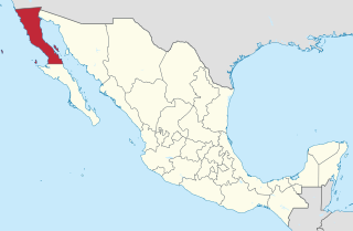
Baja California (Spanish pronunciation: [ˈbaxa kaliˈfoɾnja];, officially the Free and Sovereign State of Baja California, is a state in Mexico. It is the northernmost and westernmost of the 32 federal entities of Mexico. Before becoming a state in 1952, the area was known as the North Territory of Baja California. It has an area of 70,113 km2 and comprises the northern half of the Baja California Peninsula, north of the 28th parallel, plus oceanic Guadalupe Island. The mainland portion of the state is bordered on the west by the Pacific Ocean; on the east by Sonora, the U.S. state of Arizona, and the Gulf of California ; and on the south by Baja California Sur. Its northern limit is the U.S. state of California.

Baja California Sur, officially the Free and Sovereign State of Baja California Sur, is the second-smallest Mexican state by population and the 31st admitted state of the 32 states which make up the 32 Federal Entities of Mexico. It is also the ninth-largest Mexican state in terms of area.

The Sonoran Desert is a North American desert and ecoregion which covers large parts of the Southwestern United States in Arizona and California and of Northwestern Mexico in Sonora, Baja California, and Baja California Sur. It is the hottest desert in Mexico. It has an area of 260,000 square kilometers (100,000 sq mi). The western portion of the United States–Mexico border passes through the Sonoran Desert.

The Peninsular Ranges are a group of mountain ranges that stretch 1,500 km (930 mi) from Southern California to the southern tip of the Baja California Peninsula; they are part of the North American Coast Ranges, which run along the Pacific Coast from Alaska to Mexico. Elevations range from 500 to 10,834 feet.

San José del Cabo is a city located in southern Baja California Sur state, Mexico. It is the seat of Los Cabos Municipality lying at a shallow bay 20 miles (32 km) northeast of Cabo San Lucas on the Gulf of California. The city has a population of 136,285 as of the 2020 Census. San José del Cabo together with Cabo San Lucas are known as Los Cabos. Together they form a metropolitan area of 351,111 inhabitants.

Los Cabos is a municipality located at the southern tip of Mexico's Baja California Peninsula, in the state of Baja California Sur. It encompasses the two towns of Cabo San Lucas and San José del Cabo linked by a twenty-mile Resort Corridor of beach-front properties and championship golf courses.
Coringa Wildlife Sanctuary is a wildlife sanctuary and estuary situated near Kakinada in Andhra Pradesh, India. It is the second largest stretch of mangrove forests in India with 24 mangrove tree species and more than 120 bird species. It is home to the critically endangered white-backed vulture and the long billed vulture. In a mangrove ecosystem the water bodies of the ocean/sea and the river meet together at a certain point.

Ridgway's rail is a near-threatened species of bird. It is found principally in California's San Francisco Bay to southern Baja California. A member of the rail family, Rallidae, it is a chicken-sized bird that rarely flies.

The California killifish is a type of killifish (Fundulidae) found along the coast of southern California and Baja California.

The Pacific Flyway is a major north-south flyway for migratory birds in America, extending from Alaska to Patagonia. Every year, migratory birds travel some or all of this distance both in spring and in fall, following food sources, heading to breeding grounds, or travelling to overwintering sites.

Mission San José del Cabo or San José del Cabo Cathedral was the southernmost of the Jesuit missions on the Baja California peninsula, located in the outskirts of the modern city of San José del Cabo in Baja California Sur, Mexico.

Suaeda is a genus of plants also known as seepweeds and sea-blites. Most species are confined to saline or alkaline soil habitats, such as coastal salt-flats and tidal wetlands. Many species have thick, succulent leaves, a characteristic seen in various plant genera that thrive in salty habitats.

Oryzomys peninsulae, also known as the Lower California rice rat, is a species of rodent from western Mexico. Restricted to the southern tip of the Baja California peninsula, it is a member of the genus Oryzomys of family Cricetidae. Only about twenty individuals, collected around 1900, are known, and subsequent destruction of its riverine habitat may have driven the species to extinction.

Suaeda nigra, often still known by the former name Suaeda moquinii, is a species of flowering plant in the amaranth family, known by the vernacular names bush seepweed or Mojave sea-blite.
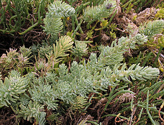
Suaeda taxifolia is a species of flowering plant in the family Amaranthaceae known by the common name woolly seablite.

The Tijuana River Estuary is an intertidal coastal wetland at the mouth of the Tijuana River in San Diego County, California, in the United States bordering Tijuana, Baja California, Mexico. It is the location of the Tijuana River National Estuarine Research Reserve, Tijuana Slough National Wildlife Refuge, and Border Field State Park. The estuary is a shallow water habitat. Often termed an intermittent estuary since its volume is subject to the discharge controlled by the seasons of the year, the volume of the estuary fluctuates and at times there is dry land, or flooded areas. It was designated a National Natural Landmark in 1973.

Tagelus californianus, common name California tagelus, is a species of saltwater clams, marine bivalve mollusks belonging to the family Solecurtidae.

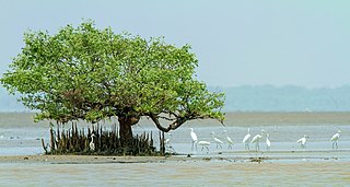
The Northwest Mexican Coast mangroves is a mangrove ecoregion of the southern Baja California Peninsula and coastal Sonora and northern Sinaloa states in northwestern Mexico. The region is transitional one between tropical and temperate seas, and they are the northernmost mangroves on the Pacific Coast of North America.
