Inza is a town and the administrative center of Inzensky District in Ulyanovsk Oblast, Russia, located on the Syuksyumka River 167 kilometers (104 mi) southwest of Ulyanovsk, the administrative center of the oblast. Population: 18,803 (2010 Census); 20,288 (2002 Census); 23,509 (1989 Census).

Baryshsky District is an administrative and municipal district (raion), one of the twenty-one in Ulyanovsk Oblast, Russia. It is located in the west of the oblast. The area of the district is 2,255.8 square kilometers (871.0 sq mi). Its administrative center is the town of Barysh. Population: 44,034 ; 31,444 (2002 Census); 36,230 (1989 Census). The population of Barysh accounts for 38.9% of the district's total population.

Cherdaklinsky District is an administrative and municipal district (raion), one of the twenty-one in Ulyanovsk Oblast, Russia. It is located in the northeast of the oblast. The area of the district is 2,442.3 square kilometers (943.0 sq mi). Its administrative center is the urban locality of Cherdakly. Population: 41,449 ; 43,865 (2002 Census); 40,887 (1989 Census). The population of Cherdakly accounts for 27.6% of the district's total population.
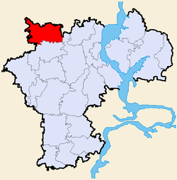
Inzensky District is an administrative and municipal district (raion), one of the twenty-one in Ulyanovsk Oblast, Russia. It is located in the west of the oblast. The area of the district is 2,020.2 square kilometers (780.0 sq mi) Its administrative center is the town of Inza. Population: 33,877 ; 40,083 (2002 Census); 59,539 (1989 Census). The population of Inza accounts for 55.5% of the district's total population.

Karsunsky District is an administrative and municipal district (raion), one of the twenty-one in Ulyanovsk Oblast, Russia. It is located in the northwest of the oblast. The area of the district is 1,768.6 square kilometers (682.9 sq mi). Its administrative center is the urban locality of Karsun. Population: 25,170 ; 29,319 (2002 Census); 32,561 (1989 Census). The population of Karsun accounts for 30.8% of the district's total population.
Kuzovatovsky District is an administrative and municipal district (raion), one of the twenty-one in Ulyanovsk Oblast, Russia. It is located in the center of the oblast. The area of the district is 2,098 square kilometers (810 sq mi). Its administrative center is the urban locality of Kuzovatovo. Population: 22,377 ; 27,225 (2002 Census); 30,218 (1989 Census). The population of Kuzovatovo accounts for 35.8% of the district's total population.

Maynsky District is an administrative and municipal district (raion), one of the twenty-one in Ulyanovsk Oblast, Russia. It is located in the central and northern parts of the oblast. The area of the district is 2,306 square kilometers (890 sq mi). Its administrative center is the urban locality of Mayna. Population: 25,826 ; 30,626 (2002 Census); 32,642 (1989 Census). The population of Mayna accounts for 27.5% of the district's total population.

Melekessky District is an administrative and municipal district (raion), one of the twenty-one in Ulyanovsk Oblast, Russia. It is located in the northeast of the oblast. The area of the district is 3,472.3 square kilometers (1,340.7 sq mi). Its administrative center is the city of Dimitrovgrad. Population: 36,718 ; 40,272 (2002 Census); 42,023 (1989 Census).

Nikolayevsky District is an administrative and municipal district (raion), one of the twenty-one in Ulyanovsk Oblast, Russia. It is located in the southwest of the oblast. The area of the district is 2,084.27 square kilometers (804.74 sq mi). Its administrative center is the urban locality of Nikolayevka. Population: 27,211 ; 30,333 (2002 Census); 34,413 (1989 Census). The population of Nikolayevka accounts for 23.5% of the district's total population.

Novospassky District is an administrative and municipal district (raion), one of the twenty-one in Ulyanovsk Oblast, Russia. It is located in the south of the oblast. The area of the district is 1,301.1 square kilometers (502.4 sq mi). Its administrative center is the urban locality of Novospasskoye. Population: 22,478 ; 23,852 (2002 Census); 22,734 (1989 Census). The population of Novospasskoye accounts for 49.3% of the district's total population.

Pavlovsky District is an administrative and municipal district (raion), one of the twenty-one in Ulyanovsk Oblast, Russia. It is located in the southwest of the oblast. The area of the district is 1,017.6 square kilometers (392.9 sq mi). Its administrative center is the urban locality of Pavlovka. Population: 15,109 ; 16,539 (2002 Census); 17,453 (1989 Census). The population of Pavlovka accounts for 37.2% of the district's total population.
Radishchevsky District is an administrative and municipal district (raion), one of the twenty-one in Ulyanovsk Oblast, Russia. It is located in the south of the oblast. The area of the district is 1,637 square kilometers (632 sq mi). Its administrative center is the urban locality of Radishchevo. Population: 14,284 ; 15,770 (2002 Census); 15,809 (1989 Census). The population of Radishchevo accounts for 32.2% of the district's total population.

Sengileyevsky District is an administrative and municipal district (raion), one of the twenty-one in Ulyanovsk Oblast, Russia. It is located in the center of the oblast. The area of the district is 1,349 square kilometers (521 sq mi). Its administrative center is the town of Sengiley. Population: 23,260 ; 26,338 (2002 Census); 29,334 (1989 Census). The population of Sengiley accounts for 29.9% of the district's total population.

Starokulatkinsky District is an administrative and municipal district (raion), one of the twenty-one in Ulyanovsk Oblast, Russia. It is located in the south of the oblast. The area of the district is 1,178 square kilometers (455 sq mi). Its administrative center is the urban locality of Staraya Kulatka. Population: 14,731 ; 17,505 (2002 Census); 19,370 (1989 Census). The population of Staraya Kulatka accounts for 38.6% of the district's total population.

Staromaynsky District is an administrative and municipal district (raion), one of the twenty-one in Ulyanovsk Oblast, Russia. It is located in the northeast of the oblast. The area of the district is 2,044.1 square kilometers (789.2 sq mi). Its administrative center is the urban locality of Staraya Mayna. Population: 18,132 ; 20,229 (2002 Census); 20,493 (1989 Census). The population of Staraya Mayna accounts for 36.0% of the district's total population.
Terengulsky District is an administrative and municipal district (raion), one of the twenty-one in Ulyanovsk Oblast, Russia. It is located in the center of the oblast. The area of the district is 1,756.3 square kilometers (678.1 sq mi) Its administrative center is the urban locality of Terenga. Population: 18,761 ; 20,617 (2002 Census); 22,551 (1989 Census). The population of Terenga accounts for 28.4% of the district's total population.

Tsilninsky District is an administrative and municipal district (raion), one of the twenty-one in Ulyanovsk Oblast, Russia. It is located in the north of the oblast. The area of the district is 1,293 square kilometers (499 sq mi). Its administrative center is the rural locality of Bolshoye Nagatkino. Population: 27,543 ; 28,628 (2002 Census); 31,496 (1989 Census). The population of Bolshoye Nagatkino accounts for 19.8% of the district's total population.
Veshkaymsky District is an administrative and municipal district (raion), one of the twenty-one in Ulyanovsk Oblast, Russia. It is located in the western central part of the oblast. The area of the district is 1,435.5 square kilometers (554.2 sq mi). Its administrative center is the urban locality of Veshkayma. Population: 19,801 ; 23,355 (2002 Census); 25,802 (1989 Census). The population of the administrative center accounts for 33.4% of the district's total population.

Barysh is a town and the administrative center of Baryshsky District in Ulyanovsk Oblast, Russia, located on the Barysh River, 139 kilometers (86 mi) southwest of Ulyanovsk, the administrative center of the oblast. Population: 17,149 (2010 Census); 18,902 (2002 Census); 20,213 (1989 Census).

Bazarny Syzgan is an urban locality and the administrative center of Bazarnosyzgansky District of Ulyanovsk Oblast, Russia. Population: 5,715 (2010 Census); 6,092 (2002 Census); 6,708 (1989 Census).