Northamptonshire is a ceremonial county in the East Midlands of England. It is bordered by Leicestershire, Rutland and Lincolnshire to the north, Cambridgeshire to the east, Bedfordshire, Buckinghamshire and Oxfordshire to the south and Warwickshire to the west. Northampton is the largest settlement and the county town.

Kettering is a market and industrial town as well as a civil parish in the North Northamptonshire district, in the ceremonial county of Northamptonshire, England. It is 45 miles (72 km) west of Cambridge, 31 miles (50 km) southwest of Peterborough, 28 miles (45 km) southeast of Leicester and 15 miles (24 km) north-east of Northampton. It is west of the River Ise, a tributary of the River Nene. The name means "the place of Ketter's people ".
The Borough of Kettering was a local government district and borough in Northamptonshire, England, from 1974 to 2021. It was named after its main town, Kettering, where the council was based. It bordered onto the district of Harborough in the neighbouring county of Leicestershire, the borough of Corby, the district of East Northamptonshire, the district of Daventry and the borough of Wellingborough.
Rothwell is a market town in North Northamptonshire, England. It is close to three larger towns, situated 4 miles [6.4km] northwest of Kettering, 7 miles [11km] southeast of Market Harborough and 8 miles [12.8km] southwest of Corby. Rothwell's nearest railway station is at Kettering on the Midland Main Line.

The Diocese of Peterborough forms part of the Province of Canterbury in England. Its seat is the Cathedral Church of Saint Peter, Saint Paul and Saint Andrew, which was founded as a monastery in AD 655 and re-built in its present form between 1118 and 1238.
Wilbarston is a village and civil parish in the English county of Northamptonshire in the Welland valley. It is administered as part of North Northamptonshire and is five miles east of the Leicestershire town of Market Harborough, via the A427. At the time of the 2001 census, the parish's population was 767 people, including Pipewell but reducing slightly to 753 at the 2011 Census. A Community Governance Review concluded in February 2015 resulted in the ward of Pipewell becoming part of the civil parish of Rushton.

Weston by Welland is a village and civil parish in the north of the English county of Northamptonshire administered as part of North Northamptonshire. As its name suggests, it is near to the River Welland that, thereabouts, forms the boundary with the county of Leicestershire. The Wheel & Compass pub stands on the village's outskirts. At the time of the 2001 census, the parish's population was 141 people, including Sutton Bassett and increasing to 246 at the 2011 Census.

The A43 is a primary route in the English Midlands and northern South East England, that runs from the M40 motorway near Ardley in Oxfordshire to Stamford in Lincolnshire. Through Northamptonshire it bypasses the towns of Northampton, Kettering and Corby which are the three principal destinations on the A43 route. The A43 also links to the M1 motorway.

Weldon is a suburban village and civil parish on the eastern outskirts of Corby, Northamptonshire, England. It is two miles away from Corby.

Great Easton is a village and civil parish in the Harborough district of Leicestershire, England. The parish had a population of 558 according to the 2001 census, increasing to 671 at the 2011 census.

Islip is a village and civil parish in North Northamptonshire, England. The village is just west of Thrapston and 7 miles (11 km) east of Kettering. The parish is bounded to the east by the River Nene and to the north by Harpurs Brook, a tributary of the Nene. The 2011 Census recorded the parish's population as 829 people.
Oxendon was a rural district in Northamptonshire, England from 1894 to 1935.

Wakerley is a linear village and civil parish in the county of Northamptonshire, England. Forming part of North Northamptonshire, Wakerley is close to, and south of, the River Welland that forms the boundary with Rutland; its nearest neighbour, Barrowden, is in that county and accessible by a footbridge. Wakerley is in the area of Rockingham Forest and Wakerley Great Wood is one of the forest's largest remnants. The population of the village is included in the civil parish of Duddington with Fineshade.

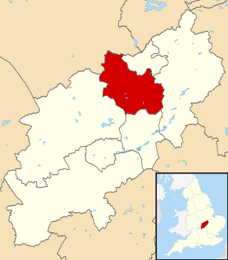
North Northamptonshire is one of two local government districts in Northamptonshire, England. Its council is a unitary authority, being a district council which also performs the functions of a county council. It was created in 2021. The council is based in Corby, the district's largest town. Other notable towns are Kettering, Wellingborough, Rushden, Raunds, Desborough, Rothwell, Irthlingborough, Thrapston and Oundle.
Brampton Ash is a civil parish and village in Northamptonshire, England. It lies in the extreme north-west of Northamptonshire and the nearest urban settlements are the nearby towns of Corby, Kettering, Desborough and Market Harborough. Running past the north of the village is the A427 road which connects Market Harborough to Oundle. At the 2011 census the population of the village was included in the civil parish of Stoke Albany.

Harringworth is a village and civil parish in North Northamptonshire, England. It is located close to the border with Rutland, on the southern bank of the River Welland, and around 5.3 miles (8.5 km) north of Corby. At the 2001 Census, the population of the parish was 247, falling to 241 at the 2011 Census.

East Carlton is a village and civil parish in the county of Northamptonshire, on the southern ridge overlooking the Welland valley to the north and covers 1,645 acres (666 ha) on a long strip of land. It is 2 miles (3.2 km) west of the town of Corby and is administered as part of North Northamptonshire but was previously in the Corby borough until 2021. At the time of the 2001 census, the parish's population was 270, reducing to 259 at the 2011 census. East Carlton is one of the Thankful Villages that suffered no fatalities during World War I.
Stoke Doyle is a village and civil parish in North Northamptonshire in England, two miles south-west of Oundle. The population of the village at the 2011 Census was included in the civil parish of Wadenhoe.
Welland Wanderer is a pair of bus services in Northamptonshire, UK.