Sutton upon Tern | |
---|---|
![]() A view from the Norman earthwork (a scheduled ancient monument) on Fordhall Farm, Sutton-upon-Tern | |
Location within Shropshire | |
Population | 1,232 (2011 Census) |
OS grid reference | SJ666317 |
Civil parish |
|
Unitary authority | |
Ceremonial county | |
Region | |
Country | England |
Sovereign state | United Kingdom |
Post town | MARKET DRAYTON |
Postcode district | TF9 |
Dialling code | 01630 |
Police | West Mercia |
Fire | Shropshire |
Ambulance | West Midlands |
UK Parliament | |
Sutton upon Tern is a civil parish in Shropshire, England. Expanded in 1914 after the abolition of the parish of Drayton in Hales, [1] its name in Old English means 'South farm/settlement' on the River Tern. [2] It lies south of Market Drayton, on the River Tern.
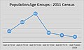
At the 2011 census the parish had a population of 1,232, [3] the majority of them between the ages of 35 and 55. [4] A description of Sutton upon Tern was written in the early 1870s:
It is unusual in that a small area of the parish, at Ternhill, is almost an exclave of the parish: only a 5m wide strip of land joins it with the bulk of the parish.
In the north-west of the parish is Service Family Accommodation for nearby Clive Barracks. The housing estates are not "behind the wire" and consist of two areas; Buntingsdale Park (mainly Officer's housing) and Buntingsdale Estate for other ranks. [6] Buntingsdale Primary School [7] and a pub are nearby.
The hamlet of Woodseaves is in the east of the parish on the A529. Woodseaves is the midpoint of the longest north–south axis of the UK. Other than a few houses there is a nearby public house, The Four Alls Inn, [8] a garden centre and a narrow gauge railway attraction. [9]
Along the western border of the parish runs the A41 that is built upon a Roman Road linking the fort of Mediolanum (Whitchurch) to Pennocrucium (Stretton, Staffordshire). [10]
Sutton upon Tern was mentioned in the 1086 Domesday Book in a district called 'Wrockwardine' under the ownership of Roger of Courseulles who was recorded as tenant-in-chief. Sutton upon Tern was recorded as having 1 mill and 12 households, containing 9 villagers, 7 ploughlands, 9 smallholders, 2 plough teams and 1 lord's plough teams. [11]
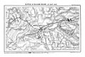
Brownhill Wood and Salisbury Hill, south of Market Drayton, was the scene of the gathering of the Earl of Salisbury's troops before the Battle of Blore Heath in 1459 during the Wars of the Roses. [12] An 18-hole golf course now occupies this site.
The first census entry for Sutton upon Tern was made in 1921 where it had a total population of 512. This figure began to grow and by 1961 the population had tripled in size to 1,622. [13] This can be attributed to the introduction of the National Health Service in 1948 allowing widespread use of new antibiotics and the post-war National Food Policy, [14] all contributing to the post-war baby boom. The population total has since peaked and has been slowly declining as shown in the census of 2011. [15]
In 1965 the civil parish was enlarged by the transfer of the part of the Staffordshire parish of Tyrley west of the Shropshire Union Canal (including the site of the lost settlement of Tyrley and Tyrley Castle) to the parish. [16] Tyrley (Tirley) Castle was located alongside the present day A529. "The castle built after the conquest by the Pantulfs" [17] is believed to date back to 1066 and later rebuilt in stone in the thirteenth-century. The castle succeeded by a newly built Manor house in the 1280s which fell into disrepair, with an eighteenth-century farmhouse built upon the site to this day. [18]
Buntingsdale Hall, an 18th-century Grade II listed building, [19] is in the parish.
Woodseaves Cutting (also known as Tyrley Canal Cutting) is a deep cut on the Shropshire Union Canal, named after the nearby hamlet to the west of the canal. Completed in 1832, it is the longest cutting on any canal in Britain. It is about 2.7 km long and up to about 21.3m deep. [20]
Tyrley Wharf, north of Woodseaves, served as a small dock above a flight of five locks. In 1911 it was used to load milk churns to be taken from the Peatswood Estate to Cadbury's factory at Knighton. [21]
Market Drayton Golf Club, founded in 1906, is an 18-hole golf course. [22]
Audlem is a village and civil parish located in Cheshire, North West England. In 2021, it had a population of 1,832.
Beeston is a village and civil parish in the unitary authority of Cheshire West and Chester, which itself is in the ceremonial county of Cheshire in the north of England. It is located approximately 10 km south-east of Chester, and approximately 3.5 km south-west of Tarporley, close to the Shropshire Union Canal. According to the 2011 census, Beeston had a population of 188.
Market Drayton is a market town and civil parish on the banks of the River Tern in Shropshire, England. It is close to the Cheshire and Staffordshire borders. It is located between the towns of Whitchurch, Wem, Nantwich, Newcastle-under-Lyme, Newport and the city of Stoke on Trent. The town is on the Shropshire Union Canal and bypassed by the A53 road.
The Shropshire Union Canal, sometimes nicknamed the "Shroppie", is a navigable canal in England. The Llangollen and Montgomery canals are the modern names of branches of the Shropshire Union (SU) system and lie partially in Wales.
Shawbury is a village and civil parish in Shropshire, England. The village is 8 miles (13 km) northeast of Shrewsbury and 12 miles (19 km) northwest of Telford.
Gnosall is a village and civil parish in the Borough of Stafford, Staffordshire, England, with a population of 4,736 across 2,048 households. It lies on the A518, approximately halfway between the towns of Newport and the county town of Staffordshire, Stafford. Gnosall Heath lies immediately south-west of the main village, joined by Station Road and separated by Doley Brook. Other nearby villages include Woodseaves, Knightley, Cowley, Ranton, Church Eaton, Bromstead Heath, Moreton, and Haughton.
Loggerheads is a village and civil parish in north-west Staffordshire, England, on the A53 between Market Drayton and Newcastle-under-Lyme. The village is close to the border with Shropshire and Cheshire. It has a Telford postcode and a Shropshire address, but is governed by the Newcastle-under-Lyme Borough Council in Staffordshire.
Woodseaves is a village in Staffordshire, England.
Longdon-upon-Tern is a village in the civil parish of Rodington, in the unitary district of Telford and Wrekin, in Shropshire, England. It is approximately 7 miles (11 km) east of Shrewsbury and 7 miles (11 km) north-west of Telford. Longdon-Upon-Tern is situated on the River Tern, a tributary of the River Severn. In 1971, the parish had a population of 127.
Baddington is a civil parish in the unitary authority of Cheshire East and the ceremonial county of Cheshire, England, which lies immediately to the south-west of Nantwich and north of Audlem. Predominantly rural with scattered farms, the civil parish has a total population of around 100 people, increasing to 212 at the 2011 Census, and includes the dispersed settlement of Hack Green, the site of a former RAF decoy station, radar station and Home Defence regional headquarters. Nearby villages include Aston, Broomhall Green, Hankelow, Ravensmoor, Sound Heath and Stapeley.
Moreton Say is a small village and sparsely populated civil parish in Shropshire, England, near the borders with Cheshire and Staffordshire, just northwest of the town of Market Drayton. It is sometimes spelled Moreton Saye or Moreton Sea. The civil parish, which also covers the hamlets of Longford and Longslow, had a total population of 429 at the 2001 census, increasing to 485 at the 2011 Census. The parish is 5,999 acres.
Stoke on Tern is a village located in Shropshire, England, on the River Tern. The civil parish is known as Stoke upon Tern.
Almington is a small village in Staffordshire, England. It is about 2 miles (3.2 km) east-northeast of Market Drayton by road, to the northwest of the villages of Hales and west of Blore Heath. Historically the manor and Almington Hall belonged to the Pandulf family, and much later, the Broughton family.
Coole Pilate is a civil parish in the unitary authority of Cheshire East and the ceremonial county of Cheshire, England, which lies to the north of Audlem and to the south of Nantwich. The area is predominantly rural with scattered farms, and a total population of 60 people. At the 2011 Census the population remained less than 100. Details are included in the civil parish of Austerson. Nearby villages include Broomhall Green, Hankelow, Hatherton and Newhall.
Buntingsdale Hall is a historic country house in the parish of Sutton upon Tern, to the southwest of Market Drayton in Shropshire, England. It became a Grade II* listed building on 14 February 1979.
Tyrley Canal Cutting is a Site of Special Scientific Interest located at Tyrley on the Shropshire Union Canal approximately 2.5 miles south of Market Drayton, to the east of the A529 in Shropshire, England.
Sutton upon Tern is a civil parish in Shropshire, England. It contains 24 listed buildings that are recorded in the National Heritage List for England. Of these, four are listed at Grade II*, the middle of the three grades, and the others are at Grade II, the lowest grade. The parish contains the village of Sutton upon Tern and is otherwise largely rural. The Shropshire Union Canal passes through the parish, and the listed buildings associated with it are two bridges and a milepost. In the parish are the country houses Buntingsdale Hall and Pell Wall, and another large house, Colehurst Manor, which are listed together with associated structures. The other listed buildings are farmhouses, farm buildings, a road bridge, a milestone, and a coach house and stables.
Tyrley was a small settlement in Staffordshire, England, now lost, and a former civil parish. It was located immediately south of Market Drayton. The name means "clearing by the River Tern" It was mentioned in the Domesday Book of 1086, when it belonged to William Pandolf, and was the site of a castle later. Tyrley (Tirley) Castle was located alongside the present day A529. "The castle built after the conquest by the Pantulfs" is believed to date back to 1066 and later rebuilt in stone in the thirteenth-century. The castle was succeeded by a newly built Manor house in the 1280s which fell into disrepair, with an eighteenth-century farmhouse built upon the site which remains to this day.
Media related to Sutton upon Tern at Wikimedia Commons