Swaraj Deep

Last updated

Swaraj Island
Swaraj Island
Havelock, Andaman & Nicobar Islands.JPG
A view of a beach in Havelock Island
India Andaman and Nicobar Islands location map.svg
Red pog.svg
Swaraj Island
Location of Havelock Island
Geography
Location Bay of Bengal
Coordinates 11°58′N93°00′E / 11.96°N 93.00°E / 11.96; 93.00 Coordinates: 11°58′N93°00′E / 11.96°N 93.00°E / 11.96; 93.00
Archipelago Andaman Islands
Adjacent bodies of water Indian Ocean
Total islands1
Major islands
  • Havelock
Area92.2 km2 (35.6 sq mi)
Length18 km (11.2 mi)
Width8 km (5 mi)
Coastline58.5 km (36.35 mi)
Highest elevation167 m (548 ft)
Highest pointYulutang
Administration
Flag of India.svg  India
District South Andaman
Island group Andaman Islands
Island sub-group Ritchie's Archipelago
Tehsil Ritchie's Archipelago Tehsil
Largest settlementGovinda Nagar
Demographics
Population6,351[ citation needed ] (2011)
Pop. density68.5/km2 (177.4/sq mi)
Ethnic groups Bengali
Additional information
Time zone
PIN 744211 [1]
Telephone code031928 [2]
Official website www.and.nic.in
Literacy84.4%
Avg. summer temperature30.2 °C (86.4 °F)
Avg. winter temperature23.0 °C (73.4 °F)
Sex ratio 1.2/
Census code35.639.0004
Official languages Hindi, English

Swaraj Island, previously known as, Havelock Island, is one of the largest islands in Ritchie's Archipelago, to the east of Great Andaman within the Andaman Islands. It belongs to the South Andaman administrative district, part of the Indian union territory of Andaman and Nicobar Islands. [3] The island is 41 km (25 mi) northeast of the capital city, Port Blair.

Contents

Etymology

Havelock Island is named after a British general, Sir Henry Havelock, who served in India. [4]

In December 2018, it was renamed, by Prime Minister Narendra Modi, as Swaraj Island as a tribute to Subhas Chandra Bose. Bose had hoisted the Indian flag at Port Blair on 30 December 1943 and proclaimed the Andaman and Nicobar Islands as liberated from British rule. He had subsequently named Neill Island as Shaheed and Havelock Island as Swaraj. [5]

History

Havelock is one of the few places that the administration of the Andaman and Nicobar Islands union territory of India has permitted and encouraged development of tourism, with a focus on promoting eco-tourism.

Havelock Island avoided much of the devastation by the 2004 Indian Ocean earthquake and its resulting tsunami and there were no documented casualties.

There is a lighthouse at the northern point of the island, near Govinda Nagar, established in 2005. [6]

On 30 December 2018, Prime Minister Narendra Modi announced that Havelock Island would be renamed as Swaraj Island. [7]

Geography

The island belongs to the Ritchie's Archipelago and is located between Peel Island and Neill Island.

Administration

Politically, Havelock Island is part of Port Blair taluk . [8]

Demographics

The island's current[ when? ] population of 6,351[ citation needed ] consists of mainly Bengali settlers. Many of these settlers have East Bengali origin as these people were given settlement by the Indian government after the Partition of India in 1947.

The six villages are:

Beaches

Radhanagar Beach on the western coast, also known as Number 7 Beach, is one of the most popular beaches on Havelock and was named "Best Beach in Asia" by Time in 2004. [10] Radhanagar beach also bagged the prestigious blue flag certification in 2020. A Blue Flag beach is an eco-tourism model endeavouring to provide the tourists or beachgoers clean and hygienic bathing water, facilities, safe and healthy environment. [11] Other notable beaches include Elephant Beach on the northwest coast and Vijay Nagar Beach (No. 5), Beach No. 3 and Beach No. 1 on the east coast. Kalapathar is another famous beach. [12]

To reach Elephant beach one needs to take a boat from Havelock Island jetty. Another way to reach Elephant beach is via trekking. The major 3 beaches at Havelock Island are namely Radhanagar Beach, Elephant Beach and Kalapathar beach. [13]

Transportation

The island can be reached from Port Blair by government-operated ferries and private cruises. [14] There are also helicopter services. [15]

A local bus connects the jetty and villages on an hourly circuit. [16] Private ferries that sail to Havelock Island are Makruzz, Green Ocean, Sea Link and ITT Majestic these cruises have different sailing time and schedule from Port Blair to Havelock Island and from Neil Island to Havelock Island. The ferry sailing to Havelock is subject to weather conditions. [17]

Within the island you can travel in a cab, a two wheeler or bus. The most convenient way is to take a cab or a two wheeler.

Travelers typically take the ferry service from Port Blair to Havelock Island, Havelock to Neil Island and Neil to Port Blair [18]

Many properties are now available at Havelock Island that can be booked. From budget to luxury all options are available. The most preferred places to stay at Havelock Island are Beach No.3, Beach No.5 and Beach No. 3. People prefer to stay closer to the beaches at Havelock Island.

Internet connectivity at Havelock Island has improved since the undersea cable from Chennai to Port Blair has been laid. The internet connectivity in all the islands has improved. At Havelock island now high-speed internet is available. Airtel and Jio are available at Havelock. [19]

Related Research Articles

Andaman Islands Archipelago in the Bay of Bengal

The Andaman Islands are an archipelago in the northeastern Indian Ocean about 130 km (81 mi) southwest off the coasts of Myanmar's Ayeyarwady Region. Together with the Nicobar Islands to their south, the Andamans serve as a maritime boundary between the Bay of Bengal to the west and the Andaman Sea to the east. Most of the islands are part of the Andaman and Nicobar Islands, a Union Territory of India, while the Coco Islands and Preparis Island are part of the Yangon Region of Myanmar.

Andaman and Nicobar Islands Union territory of India

The Andaman and Nicobar Islands is a union territory of India consisting of 572 islands, of which 38 are inhabited, at the junction of the Bay of Bengal and the Andaman Sea. The territory is about 150 km (93 mi) north of Aceh in Indonesia and separated from Thailand and Myanmar by the Andaman Sea. It comprises two island groups, the Andaman Islands (partly) and the Nicobar Islands, separated by the 150 km wide Ten Degree Channel, with the Andaman islands to the north of this latitude, and the Nicobar islands to the south. The Andaman Sea lies to the east and the Bay of Bengal to the west. The island chains are thought to be a submerged extension of the Arakan Mountains.

Port Blair Capital city of the Andaman and Nicobar Islands, India

Port Blair is the capital city of the Andaman and Nicobar Islands, a union territory of India in the Bay of Bengal. It is also the local administrative sub-division (tehsil) of the islands, the headquarters for the district of South Andaman and is the territory's only notified town.

Little Andaman Island is the fourth largest of the Andaman Islands of India with an area of 707 km2, lying at the southern end of the archipelago. It belongs to the South Andaman administrative district, part of the Indian union territory of Andaman and Nicobar Islands. It lies 88 km (55 mi) south of Port Blair, the capital of Andaman and Nicobar Islands.

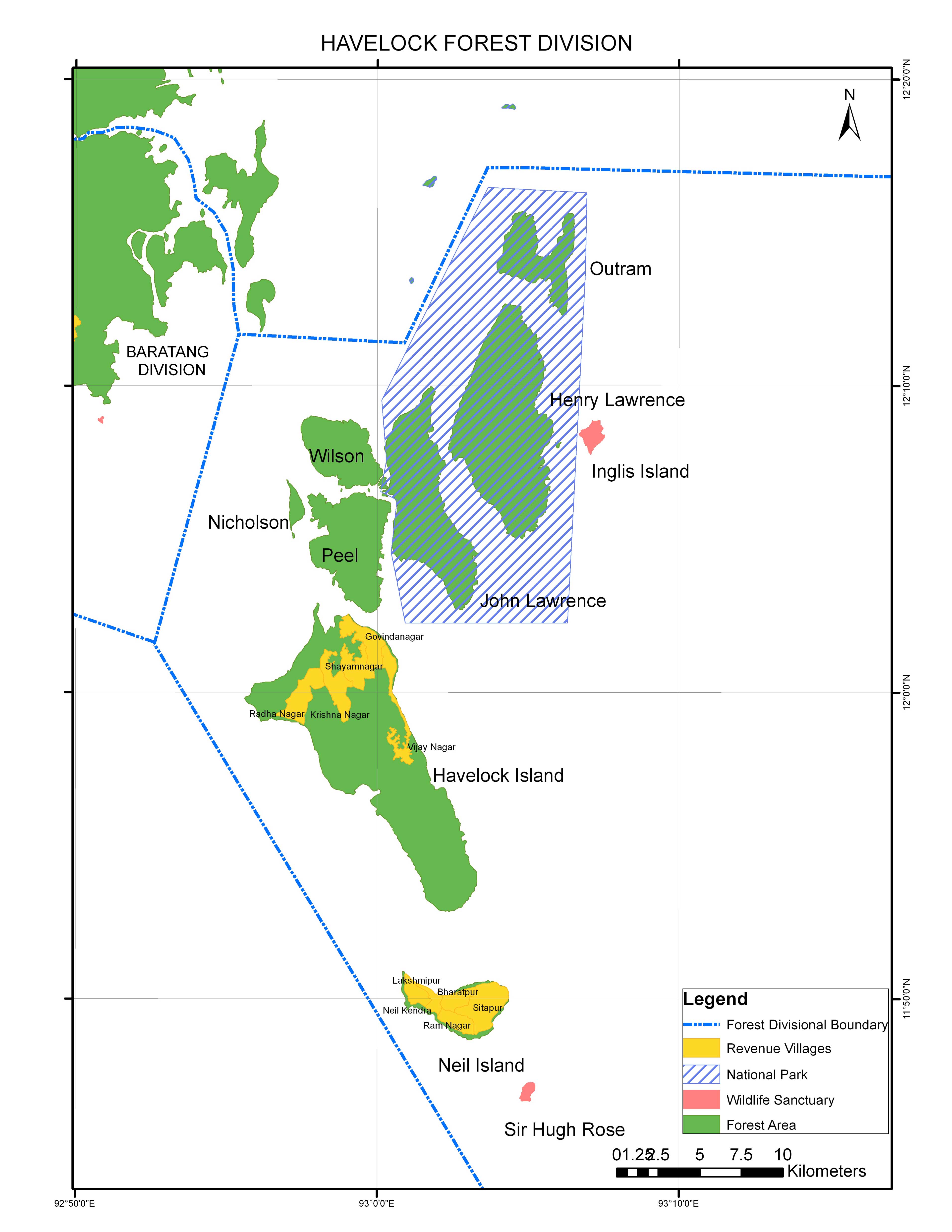
Ritchie's Archipelago is a cluster of smaller islands which lie 20 km (12 mi) east of Great Andaman, the main island group of the Andaman Islands. The Islands belong to the South Andaman administrative district, part of the Indian union territory of Andaman and Nicobar Islands.

Indira Point, southernmost point of India's territory, is a village in the Nicobar district at Great Nicobar Island of Andaman and Nicobar Islands in India. It is located in the Great Nicobar tehsil.

Baratang Island is an island of the Andaman Islands. It belongs to the North and Middle Andaman administrative district, part of the Indian union territory of Andaman and Nicobar Islands. The island lies 150 km (93 mi) north of Port Blair.

Diglipur is the largest town of North Andaman Island, in the Andaman Archipelago, India. It is located on the southern side of Aerial Bay, at 43 metres above sea level, 298 kilometres north of Port Blair. It is crossed by the Kalpong River, the only river of the Andaman islands. Saddle Peak, the highest point in the archipelago, lies about 10 km to the south. Diglipur is also a county (tehsil) of the North and Middle Andaman District of the Andaman and Nicobar Islands union territory. Its area is 884 km2, and its population was 42,877 people as of 2001|.

Mayabunder is a town and a tehsil in the northern part of Middle Andaman Island, Andaman Archipelago, India. The name is also spelled Maya Bunder or Maya Bandar. As of 2001, the county had 23,912 inhabitants, of which 3182 were in the town. It was settled in the British colonial period by immigrants from Myanmar and ex-convicts from Mainland India.

Neil Island

Neil Island, officially known as Shaheed Dweep, is an island of the Andaman Islands, located in Ritchie's Archipelago. It belongs to the South Andaman administrative district, part of the Indian union territory of Andaman and Nicobar Islands. the island lies 36 km (22 mi) northeast from Port Blair.

Ross Island, officially known as Netaji Subhas Chandra Bose Island, is an island of the Andaman Islands. It belongs to the South Andaman administrative district, Andaman and Nicobar Islands. The island is situated 3 km (2 mi) east from central Port Blair. The historic ruins are a tourist attraction.

Campbell Bay (Great Nicobar) Village in Andaman and Nicobar Islands, India

Campbell Bay is a village in the Nicobar district of Andaman and Nicobar Islands, India. It is located in the Great Nicobar tehsil. The island's Indira Point is famous for being the southernmost point of India.

Jal Hans is a commercial seaplane service based in the Andaman and Nicobar Islands of India. It is a pilot project that was launched on 30 December 2010 by the then Indian Civil Aviation Minister, Praful Patel, at Juhu Aerodrome in Mumbai. The airline is jointly owned by Pawan Hans, India's largest helicopter services provider, and the Andaman and Nicobar administration and is run on an equal profit and loss basis between them.

Devendra Kumar Joshi

Admiral Devendra Kumar Joshi, PVSM, AVSM, YSM, NM, VSM is the Lieutenant Governor of Andaman and Nicobar Islands and the Vice Chairman of Islands Development Agency (IDA). He was an Admiral in the Indian Navy and served as the 21st Chief of Naval Staff of the Indian Navy, having assumed office on 31 August 2012. He is a specialist in anti-submarine warfare. He resigned on 26 February 2014, taking responsibility for a series of accidents, thus becoming the first Indian Navy Chief to resign.

2014 Andaman boat disaster was an incident which occurred on 26 January 2014, when a tourist boat capsized near Port Blair, Andaman and Nicobar islands, India, killing 22 people. The boat "Aqua Marine" was carrying 45 tourists from Tamil Nadu and Mumbai.

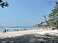
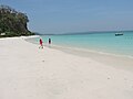
Tourism in Andaman and Nicobar Islands relates to tourism in union territory of India, Andaman and Nicobar Islands. The Andamans are an archipelago of over 570 tropical islands, of which only 36 are inhabited. In 2004 Radhanagar beach at Havelock Island was bestowed with the title of "Asia’s Best Beach" and as the world's seventh most spectacular beach by Time Magazine.

Govinda Nagar is a village in the Nicobar district of Andaman and Nicobar Islands, India. It is located in the Great Nicobar tehsil. It was developed as a tsunami shelter to house people displaced by the 2004 Indian Ocean earthquake and tsunami.

Long Island is an island of the Andaman Islands. It belongs to the North and Middle Andaman administrative district, part of the Indian union territory of Andaman and Nicobar Islands. the island is lying 80 km (50 mi) north from Port Blair.

John Lawrence Island is an island of the Andaman Islands and belongs to the South Andaman administrative district, part of the Indian union territory of Andaman and Nicobar Islands. the island is 54 km (34 mi) northeast from Port Blair.

The Andaman and Nicobar Islands is an archipelago of 572 islands of which 37 are inhabited. It is a union territory of India.

References

  1. "A&N Islands - Pincodes". 22 September 2016. Archived from the original on 23 March 2014. Retrieved 22 September 2016.
  2. "STD Codes of Andaman and Nicobar". allcodesindia.in. Retrieved 23 September 2016.
  3. "Village Code Directory: Andaman & Nicobar Islands" (PDF). Census of India. Retrieved 16 January 2011.
  4. Llewellyn-Jones, Rosie (2007). The Great Uprising in India, 1857-58: Untold Stories, Indian and British. Boydell & Brewer. p. 168. ISBN   978-1-84383-304-8.
  5. Ananya Bhardwaj (25 December 2018). "Andaman's most-visited islands to be renamed during PM Modi visit". Hindustan Times. Retrieved 31 December 2018.
  6. "Narcondam Island". Directorate General of Lighthouses and Lightships. Retrieved 18 October 2016.
  7. "PM Narendra Modi renames 3 islands of Andaman Nicobar". The Times of India. 30 December 2018. Retrieved 31 December 2018.
  8. "DEMOGRAPHIC – A&N ISLANDS" (PDF). andssw1.and.nic.in. Retrieved 23 September 2016.
  9. Map
  10. "Archived copy". Archived from the original on 23 January 2009. Retrieved 19 January 2009.{{cite web}}: CS1 maint: archived copy as title (link)
  11. Kumar, Ravi Prakash (15 October 2020). "8 Indian beaches get prestigious Blue Flag certification. Check list here". mint. Retrieved 13 February 2021.
  12. beaches map
    - CNN
  13. "Havelock Island Tourism - Detailed Travel Guide 2021 with Photos". www.experienceandamans.com. Retrieved 13 February 2021.
  14. A & N Administration. "Ferry Program for Neil, Havelock & Rangat" . Retrieved 15 October 2013.
  15. A & N Administration. "Helicopter Inter Island Schedule" . Retrieved 15 October 2013.
  16. bus
  17. "Ferry and Cruise Booking and Timing in Andaman in 2021". www.experienceandamans.com. Retrieved 13 February 2021.
  18. "Ferry in andaman portblair to havelock".{{cite web}}: CS1 maint: url-status (link)
  19. "Havelock Island".{{cite web}}: CS1 maint: url-status (link)