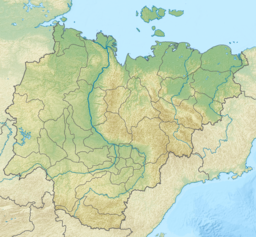
The Indigirka is a river in the Sakha Republic in Russia between the Yana to the west and the Kolyma to the east. It is 1,726 kilometres (1,072 mi) long. The area of its basin is 360,000 square kilometres (140,000 sq mi).

The Yana is a river in Sakha in Russia, located between the Lena to the west and the Indigirka to the east.

The Chersky Range is a chain of mountains in northeastern Siberia between the Yana and Indigirka Rivers. Administratively, the area of the range belongs to the Sakha Republic, although a small section in the east is within Magadan Oblast. The highest peak in the range is the 3,003-metre (9,852 ft)-tall Peak Pobeda, part of the Ulakhan-Chistay Range. The range also includes important places of traditional Yakut culture, such as Ynnakh Mountain (Mat'-Gora) and kigilyakh rock formations.

Lake Ozhogino is a large shallow freshwater lake in Sakha, Russia. It has an area of 157 km². It freezes up in late September and stays icebound until June. Ozhogin River flows from the lake.
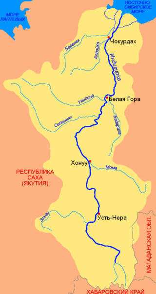
The Moma is a river in Yakutia in Russia, a right tributary of the Indigirka. The length of the river is 406 kilometres (252 mi), the area of its drainage basin is 30,200 square kilometres (11,700 sq mi).

Momsky District is an administrative and municipal district, one of the thirty-four in the Sakha Republic, Russia. It is located in the northeast of the republic. The area of the district is 104,600 square kilometers (40,400 sq mi). Its administrative center is the rural locality of Khonuu. As of the 2010 Census, the total population of the district was 4,452, with the population of Khonuu accounting for 55.6% of that number.

Khonuu is a rural locality and the administrative center of Momsky District in the Sakha Republic, Russia, located on the right bank of the Indigirka River. Population: 2,476 (2010 Census); 2,494 (2002 Census); 3,057 (1989 Soviet census).
The Selennyakh is a river in Sakha Republic, Russia. It is a left tributary of the Indigirka.

The Polousny Range is a mountain range in the Sakha Republic, Far Eastern Federal District, Russia.

The Aby Lowland is a low alluvial plain located in the Sakha Republic, Far Eastern Federal District, Russia. Administratively most of the territory of the lowland is part of Aby District (Aby Ulus).
The Moma Range is a range of mountains in far North-eastern Russia. Administratively the range is part of the Sakha Republic of the Russian Federation. The nearest town is Khonuu, served by Moma Airport.

The Ulakhan-Chistay Range is a range of mountains in far North-eastern Russia. Administratively the range is part of the Sakha Republic of the Russian Federation.
The Selennyakh Range is a range of mountains in far North-eastern Russia. Administratively the range is part of the Sakha Republic of the Russian Federation. The town of Deputatsky, capital of the Ust-Yansky District, is located in the area of the range.

Emanda is a freshwater lake in Tomponsky District, Sakha Republic, Russia. The lake is located in a desolate area where there is no permanent population and few visitors. There are burbot, pike and grayling in its waters.

The Chibagalakh Range is a mountain range in the Sakha Republic (Yakutia), Far Eastern Federal District, Russia.
The Chibagalakh is a river in the Republic of Sakha in Russia. It is a left hand tributary of the Indigirka. It is 140 kilometres (87 mi) long, with a drainage basin of 9,100 square kilometres (3,500 sq mi).

The Khastakh or Tuora-Yuryakh is a river in the Sakha Republic (Yakutia), Russia. It is one of the two tributaries giving origin to the Indigirka. The river has a length of 251 kilometres (156 mi) and a drainage basin area of 10,500 square kilometres (4,100 sq mi). The upper stretch of its course is also known as Khalkan.

Omuk-Kyuyol or "Omuk-Kyuyel" is a freshwater lake in the Sakha Republic (Yakutia), Russia.