Related Research Articles

South Kivu is one of 26 provinces of the Democratic Republic of the Congo. Its capital is Bukavu.
Banyamulenge, also referred to as Nyamurenge and Banyamurenge Is a community from the Democratic Republic of the Congo's South Kivu province. The Banyamulenge are culturally and socially distinct from the Tutsi of North Kivu, with most speaking Kinyamulenge, a mix of Kinyarwanda, Kirundi, Ha language, and Swahili. Banyamulenge are often discriminated against in the DRC due to their Tutsi phenotype, similar to that of people living in the Horn of Africa, their insubordination towards colonial rule, their role in Mobutu's war against and victory over the Simba Rebellion, which was supported by the majority of other tribes in South Kivu, their role during the First Congo War and subsequent regional conflicts (Rally for Congolese Democracy–Goma, Movement for the Liberation of the Congo, National Congress for the Defence of the People, and more importantly for the fact that two of the most influential presidents of their country declared them as enemy of the State both in 1996 and 1998.
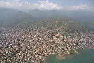
Uvira is a city in the South Kivu Province of the Democratic Republic of the Congo (DRC). It serves as the capital of the Uvira Territory and acts as an economic and transportation hub within the region. Uvira is home to the Roman Catholic Diocese of Uvira, a suffragan of the Archdiocese of Bukavu. The city boasts a diverse population and is well-known for its vibrant trade, flourishing fishing industry, and cultural heritage.

The Bembe people are an ethnic group based in the eastern Democratic Republic of the Congo and western Katavi Region of Tanzania. They live mainly in the territory of Fizi in South Kivu. The Bembe are also in the province of Tanganyika in the city of Kalemie. The Bembe people a subgroup of the larger Mongo people. In 1991, the Bembe population of the DRC was estimated to number 252,000 and around 1.5 million in 2005.
Fizi is a territory in the south of Sud-Kivu Province, Democratic Republic of the Congo, bordering the South Kivu territories of Uvira, Mwenga and Shabunda to the north, Lake Tanganyika or Tanzania in the east, and the provinces Katanga in the south and Maniema in the west.
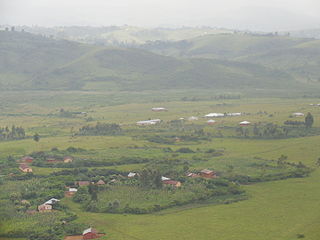
Minembwe is a group of several villages located in the highlands of the Fizi Territory, in the South Kivu Province of the Democratic Republic of the Congo (DRC). It is situated at an altitude of about 2,500 meters above sea level, in a hilly and mountainous region covered with forests, which provides fertile land for agriculture. It is approximately 150 kilometers south of Bukavu, the capital city of South Kivu. The region is also home to various streams and rivers that flow into Lake Tanganyika, the second-deepest lake in the world.
Mulenge is a village encircled by hills in the Kigoma grouping in Uvira Territory, South Kivu, Democratic Republic of Congo. It is located on the high plateaus of the Itombwe massif, overlooking the locality of Uvira. The area was inhabited by the remnants of the autochthonous population of African Pygmies and Bantu ethnic groups such as the Mbuti, Fuliiru and Vira. The southeastern slope is inhabited by the Babembe, related to the Warega of the west, great hunters and ancient warriors. The region is among the most productive in the country, with two crops that can normally be harvested each year. Principal food crops include bananas, sweet potatoes, cassava, maize, rice, sorghum, beans, soybean and tomato.

The Fuliiru people are a Bantu ethnic group, a sub-group of the Kivu.
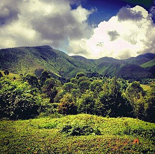
The Itombwe Mountains are a range of mountains in the South Kivu province of the Democratic Republic of the Congo (DRC). They run along the west shore of the northern part of Lake Tanganyika. They contain a vast area of contiguous montane forest and are home to a rich diversity of wildlife.

Uvira Territory is a territory in South Kivu, Democratic Republic of the Congo. It is bordered by Walungu Territory to the north, Mwenga Territory to the west, Fizi Territory to the south, and Burundi and Lake Tanganyika to the east. Its capital is Uvira. It is recognized as one of the nine major socio-economic cities in the country.

Lulenge is one of the four sectors in the Fizi Territory of the South Kivu Province in the eastern region of the Democratic Republic of the Congo (DRC). It is situated near the Kiloba and Makena villages, at an altitude of 943 meters. Its capital is Kilembwe. Lulenge is bordered to the north by the Itombwe sector and Mwenga Territory. In the east, it is bordered by Lake Tanganyika and the Mutambala sector. In the south, it is bordered by the N’gangya sector, and in the west by Shabunda Territory.

Sange is a village in the Uvira Territory of the South Kivu Province, Democratic Republic of the Congo. Sange is situated 24 km from the Burundian border and has an altitude of 1,021 meters. The region is sandy, with sandy loam and sandy clay covering most of the village, making it one of the most fertile lands in Uvira territory. The northwest basin of Lake Tanganyika, which encompasses Uvira territory, is characterized by outcrops of very ancient (Precambrian) and very recent (Quaternary) rocks. A rapid morphological study of the Sange village suggests that the region possesses black soils of the Chernozem group, soils of the Solonchak type, and Alkali soils.
Bwegera is a village in the Bafuliiru Chiefdom in the Uvira Territory of South Kivu Province, Democratic Republic of the Congo. Bwegera has an elevation of 952 meters and is situated in the vicinity of the Kakamba and Nyaruhuhuma villages. The region It's crossed by Lake Tanganyika, providing a vital source of water and transportation for the local inhabitants. Bwegera is rich in building materials such as rubble, sand, and baked bricks, making it an ideal location for construction and development. The region also encompasses a vast rural area where agriculture, animal breeding, and fishing are the primary means of livelihood. The fertile land and favorable climate provide ideal conditions for growing a variety of crops, including maize, beans, cassava, and sorghum. Furthermore, the region's proximity to the lake makes fishing a crucial economic activity, providing a source of food and income for many families.

Mutambala is a sector that constitutes one of the four sectors in the Fizi Territory of the South Kivu Province in the eastern part of the Democratic Republic of the Congo. Mutambala is situated near Lake Tanganyika, in the west by the Lulenge sector, in the north by the Tangani'a sector, and in the south by the Ngandja sector. It has a surface area of 777 km 2. The sector consists of five groupings (groupements), including the Basimukindja groupings, the Batombwe groupings, and the Babwari groupings.

The Ruzizi Plain is a valley situated between the Mitumba mountain chain and the Ruzizi River. It serves as a natural border, separating the Democratic Republic of the Congo (DRC) from Burundi and Rwanda on the other side. The Ruzizi Plain is an integral part of the larger Western Rift Valley, which stretches across several African countries. It is traversed by the Ruzizi River, which flows from Lake Kivu through the plain and into Lake Tanganyika. It covers an area of 175,000 hectares divided between Burundi, Rwanda and the DRC. In Burundi, the plain extends to the northern sector of Imbo. It is bounded by parallels 2°36′ and 3°26′ south latitude and by meridians 29°00′ and 29°26 east longitude—an area of 1025 km2. The Congolese side is bounded to the north by the plain of Bugarama (Rwanda), to the east by the plain of Imbo (Burundi), to the West by the chain of Mitumba and to the South by Lake Tanganyika. The region covers thus about 80,000 hectares with 80 kilometers in length.
Bibogobogo, also known as Bibokoboko in Kibembe, is a village in the middle plateaus of the Mutambala Sector in the Fizi Territory in the South Kivu Province of the Democratic Republic of the Congo (DRC). It is situated in the forested mountains and middle plateaus, overlooking Baraka in the south-west, near Kisombe and Bibokoboko II villages. Bibogobogo shares the borders with Uvira Territory in the North, the Mwenga Territory and Shabunda Territory in the West, the Kalemie Territory in the South, and Lake Tanganyika in the East. The regional soil is composed of metals, including sodium, potassium, calcium, magnesium, iron, aluminium and mercury, making it suitable for gold plating, mercury pollution, pollution index and agriculture.

The Nyindu people, are an ethnic group predominantly found along the Ulindi River in the north, west, and south, as well as the Kilungutwe River, located in the Mwenga Territory in the southern part of South Kivu Province in the eastern region of the Democratic Republic of the Congo (DRC). The Nyindu people belong to the Bantu ethnic group and linguistic family, which is among the most populous and diverse ethnic groups in the South Kivu Province. They are known for their traditional agricultural practices, which include cultivating crops such as maize, cassava, and beans. They also engage in animal husbandry, particularly with cattle. The Nyindu are organized into clans, and each clan has a chief who serves as a leader and arbitrator.
Kilungutwe is a small village situated in the picturesque valley of the Kilungutwe River in the Mwenga Territory of the South Kivu Province, located in the eastern part of the Democratic Republic of the Congo. The village is situated in close proximity to the neighboring villages of Kirukungutu and Chowe, which share similar characteristics and cultural traditions. The region is unique and serves as a melting pot for many ethnic groups, boasting a rich and diverse ethnocultural landscape. It is also a point of confluence for numerous ethnic groups, including the Lega, the Nyindu, Shi, Fuliiru, Holoholo, Bwari, Vira, Hunde, Nyanga, and Amba people. Each group has its unique language, customs, and traditions, creating a vibrant tapestry of cultural diversity in the region.

The Makobola massacre occurred from December 30, 1998, to January 2, 1999, in the small village of Makobola, located approximately 15 kilometers south of Uvira, on the border between Fizi Territory and Uvira Territory in the South Kivu Province of the Democratic Republic of the Congo (DRC). The Rally for Congolese Democracy, a predominantly Tutsi Rwandan-backed armed group led by Ernest Wamba dia Wamba, killed over 800 civilians, largely belonging to the Babembe community.
Nyambasha is a village located in the Kalehe Territory, in the vicinity of Lake Kivu in the South Kivu Province in the eastern region of the Democratic Republic of the Congo. It is 1599 meters above sea level and is situated nearby Kasheke and Lemera.
References
- ↑ "Secteurs et Chefferies (Niveau 3 Rural)" (PDF). https://unstats.un.org (in French). New York, New York, United States. 2021. p. 15. Retrieved 2023-06-04.
{{cite web}}: External link in|website= - ↑ "GESTION DES CONFLITS FONCIER ET COUTUMIER COMME FREIN DE DEVELOPPEMENT SOCIO-ECONOMIQUE DE SECTEUR DE TANGANYIKA TERRITOIRE DE FIZI CAS DE BASIMUKUUA NORD". www.africmemoire.com. Retrieved 2023-06-04.
- 1 2 "videfi". videfi-videfi.blogspot.co.uk. Retrieved 2017-05-27.
- ↑ "generalites". mmbondo.tripod.com. Retrieved 2017-05-27.
- ↑ "Territoire – Fizi Itombwe" . Retrieved 2023-06-05.
- ↑ "Economie – Fizi Itombwe" . Retrieved 2023-06-05.
- ↑ videfi. "videfi" . Retrieved 2023-06-05.
- ↑ "Fizi Territory Democratic Republic of Congo". www.helprapevictim.org. Retrieved 2023-06-05.
- ↑ "Territoire – Fizi Itombwe" . Retrieved 2023-06-05.
- ↑ "Economie – Fizi Itombwe" . Retrieved 2023-06-05.
- ↑ "South Kivu: A spiralling humanitarian crisis". OCHA. 2018-02-22. Retrieved 2023-06-05.
- ↑ "EXCLUSIVE: Inside the Congolese army's campaign of rape and looting in South Kivu". The New Humanitarian. 2017-12-18. Retrieved 2023-06-05.