The Bembe people predominantly inhabit the territory, though it is also characterized by considerable ethnocultural diversity, with smaller ethnic groups such as the Babuyu, Babwari, and Bazoba residing in various villages throughout the area.[5] Administratively, Fizi Territory is subdivided into four sectors: Lulenge, Mutambala, Ngandja, and Tanganyika.[3][6] Its economy is primarily driven by agriculture, fishing, livestock farming, and artisanal mineral extraction.[7] The Kyimbi (also known as Bendera) hydroelectric plant serves as a key source of power generation, although the territory's energy infrastructure remains limited.[2] Other facilities, such as the Magembe and Nundu stations, ceased operation during the Second Congo War, whereas a small hydroelectric unit in Malikya, close to Baraka, remains active.[2]
Geography
Terrain and climate
Fizi Territory landscape is dominated by mountainous terrain and a coastal plain along the eastern edge bordering Lake Tanganyika.[6] This plain averages about two kilometers in width but widens significantly in the southern region, known as Kenya, where it reaches roughly twelve kilometers.[2] In certain stretches, such as near Pemba and Luanga, the plain disappears entirely, leaving the lake's waters to crash directly against steep escarpments.[2] The coastal belt extends from the Kambakulu River up to the Lweka River, which serves as the natural border between the Tanganyika and Mutambala sectors.[2]
Inland, toward the center, south, and north of the territory, rises a vast plateau framed by parallel mountain chains oriented in a south–north direction. The highest peaks of these mountains exceed 2,500 meters in altitude and form part of the larger Mitumba range.[2] The plateau descends abruptly to the east, overlooking Lake Tanganyika. The Lukongo summit, located near the administrative headquarters of the territory, stands at about 1,400 meters above sea level.[2] The Baraka–Fizi road, which connects the lakeside city of Baraka to the interior, crosses a steep rocky escarpment reminiscent of the Nyangezi escarpment found in the neighboring Walungu Territory. Toward the west, the plateau inclines gently from east to west, a gradient that is mirrored by the flow of local rivers.[2]
The territory experiences varied climatic conditions influenced by altitude. The low-lying coastal plains are generally hot, with average temperatures around 35°C, while the middle and high plateaus are significantly cooler, averaging 24°C.[6] Altitude in the territory ranges from approximately 750 meters near the lakeshore to 1,300 meters and up to 1,700 meters inland toward the highlands.[6]
Administration and governance
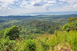
A panoramic view of Fizi Territory near Sebele in the foreground, with the expansive Lake Tanganyika and the Ubwari Peninsula visible in the background.
Administratively, Fizi Territory was established under the Belgian colonial ordinance-law of 8 August 1935.[7] The original administrative center was located in Kalembelembe before being relocated to a settlement named Fishi, a name derived from the Kibembe language, later modified by colonial authorities to Fizi. The territory takes its name from this administrative center.[7]
Fizi Territory is subdivided into four sectors: Lulenge, Mutambala, Ngandja, and Tanganyika. These are further divided into 18 groupements (groupings) and 132 localités (villages).[7] The territory serves as an administrative unit responsible for the coordination, supervision, and support of state and provincial functions. Governance at the territorial level is overseen by a Territorial Administrator, who is supported by two Assistant Territorial Administrators.[8][9] These officials are appointed by the president of the republic upon recommendation from the Minister of the Interior and Security, Decentralization, and Customary Affairs, following proposals by the provincial governor.[8] The Territorial Administrator acts as the representative of the state and the province. Additionally, the Territorial Administrator and their assistants hold the status of judicial police officers with general jurisdiction and are empowered to requisition state services when required for the public interest.[8] Regular administrative reports are submitted to the provincial governor and forwarded to the national Ministry of the Interior and Security, Decentralization, and Customary Affairs.[8]
In terms of political representation, Fizi Territory is represented in the 2024–2029 National Assembly by four deputies: Théophile Basoshi Lubwe (A/A-UNC), Janvier Msenyibwa Apele (2A/TDC), who replaced Jean-Jacques Myewa Elakano, Obedi Nyamangyoku Ishibwela (AFDC-A), and Th Tchakubuta Mufaume (AAAP).[13]
History
The region has a long history of independence from Kinshasa. It was the location of the maquis set up by Laurent-Désiré Kabila in 1967,[14] as well as the place where Laurent-Désiré Kabila raised his son, the former president Joseph Kabila, in 1973.[15]
A 1996 aerial photograph showing the Mihanda refugee camp in Zaire, situated within the Mitumba Mountains. The camp is densely populated, with over 500 tents set up across the landscape. The tents are arranged in clusters, covering a significant area amidst the rugged terrain of the mountains.
The eruption of the First Congo War (1996–1997), precipitated by the fallout of the 1994 Rwandan genocide, drastically destabilized the region. Following the genocide, the Rwandan Patriotic Front (RPF), under the leadership of Paul Kagame, ousted the Hutu-led regime of President Juvénal Habyarimana. However, the RPF's military incursions extended into eastern Zaire (present-day Democratic Republic of the Congo), targeting not only Hutu insurgent factions but also perpetrating extensive violence against Hutu civilians.[16][17][18]United Nations High Commissioner for Refugees (UNHCR) consultant Robert Gersony documented these atrocities, estimating that between 5,000 and 10,000 individuals were killed monthly during mid-1994. The influx of over two million Rwandan Hutu refugees into eastern Zaire exacerbated tensions in provinces such as South Kivu.[19][20][21] The Zairean government under President Mobutu Sese Seko was unable to adequately address the humanitarian and security crises resulting from this influx.[22] By 1996, the Rwandan Patriotic Army (RPA), along with Ugandan forces and the Burundian Forces Armées Burundaises (FAB), began supporting Banyamulenge and other Tutsi militias operating in eastern Zaire.[22] Belgian legal and political scholar Filip Reyntjens characterizes the First Congo War as the intersection of two concurrent agendas: a legitimate resistance movement by Congolese Tutsi fearing retaliation, and the strategic use of this struggle by the Rwandan government to justify the RPA's military intervention in Zaire.[23] On 12 September 1996, Banyamulenge militias launched attacks in the Itombwe Sector of Mwenga Territory, specifically in the villages of Kanyura and Makutano.[24] Nine civilians, including prominent local leaders and their families, were executed. The casualties included a Rega ethnic administrator and the chief of the Basimunyaka II groupement, a Bembe from Fizi Territory, along with two of his relatives. These killings were widely perceived by local communities as the onset of a systematic campaign of ethnically targeted violence.[24]
MONUSCO peacekeepers and a FARDC Navy sailor in a village of Fizi Territory
As the Alliance des Forces Démocratiques pour la Libération du Congo (AFDL), supported by the RPA and Burundian forces, advanced through South Kivu, they were implicated in multiple massacres within Fizi Territory. Beginning in October 1996, AFDL and RPA units also initiated the conscription of child soldiers in the territories of Uvira, Fizi, and the city of Bukavu.[24] In Bukavu, recruitment operations were carried out from the AFDL headquarters situated in the Lolango Building on Avenue Maniema. The recruited children underwent rudimentary military training in the village of Kidoti before being deployed to active combat zones.[24] In late October 1996, AFDL and RPA forces killed 27 civilians, primarily women and children, in the village of Mboko, located approximately 52 kilometers south of Uvira. Victims attempting to escape across Lake Tanganyika to Tanzania were either shot or drowned.[24] On 28 October 1996, another massacre occurred in Abala-Ngulube, a village situated at the junction of the Moyen Plateau and Haut Plateau near Minembwe. In this attack, 101 civilians belonging to the Bembe ethnic group and members of the Third Malikia wa Ubembe Church were killed by AFDL and RPA forces.[24] Many victims were burned alive inside the church after refusing to evacuate the village. This attack followed an ambush in which Bembe fighters reportedly killed two AFDL and RPA soldiers in the surrounding area.[24] Since then, the Third Malikia wa Ubembe Church has observed an annual commemoration on 28 October to honor the victims.[24]
The violence of this period ultimately contributed to the fall of Kinshasa in May 1997, which led to the overthrow of Mobutu and the rise of Laurent-Désiré Kabila as the new head of state. Subsequently, the country was renamed the Democratic Republic of the Congo.[25][26] Despite the Congolese facade of the AFDL movement, a significant number of its officials were, in fact, members of the RPF.[27] As a result, numerous Rwandan nationals occupied prominent positions within the new Congolese administration.[27] The Congolese armed forces came under the de facto leadership of Rwandan General James Kabarebe, who was appointed Chief of Staff.[27]
During the Second Congo War, which erupted in 1998, Fizi Territory was plunged into intense insecurity and conflict. The war was triggered by deteriorating relations between President Laurent-Désiré Kabila and his former allies in Rwanda and Uganda, whom he accused of harboring coup d'état ambitions and of interfering in Congolese sovereignty.[28][29] Allegations also surfaced that the United States provided indirect support to Rwanda during this period, including military training by the Rwanda Interagency Assessment Team (RIAT), reportedly to secure access to the DRC's rich mineral resources.[30][31] Additional reports implicated American officials and organizations, such as Roger Winter of the U.S. Committee for Refugees and Immigrants, in fueling insurgent activities.[32] In turn, Kabila dismissed Rwandan General James Kabarebe from his post as Chief of Staff and ordered all Rwandan troops to leave the country.[28][29] This action triggered a swift and violent response, as Rwanda and Uganda backed a new rebel movement, the Rassemblement Congolais pour la Démocratie (RCD). On 2 August 1998, mutinous elements within the Congolese army, alongside Rwandan, Ugandan, and Burundian forces, declared their rebellion from Goma.[33] The RCD and its allies rapidly seized control of key areas across eastern and northern DRC, including parts of North and South Kivu, Orientale Province, North Katanga, and Équateur Province.[33] However, their push toward the capital, Kinshasa, and the western province of Bas-Congo was thwarted by military reinforcements from Angola and Zimbabwe, who intervened in support of Kabila.[33]
This military and political fragmentation resulted in the de facto partition of the country. Kabila's regime, bolstered by Zimbabwean, Angolan, Namibian, Chadian, and Sudanese troops, maintained control over the western and central regions.[33] Conversely, the eastern regions fell under the authority of the RCD's armed wing, the Armée Nationale Congolaise (ANC), supported by Rwandan, Ugandan, and Burundian forces.[33] In an attempt to push back against this eastern coalition, Kabila allied with local militias, most notably the Mayi-Mayi, and with Burundian and Rwandan Hutu rebel groups, including the Forces pour la Défense de la Démocratie (FDD) and the Armée de Libération du Rwanda (ALiR), which included elements of the former Rwandan army and Interahamwe militia.[33] Simultaneously, Uganda, while holding significant portions of Orientale Province, sponsored the formation of a rival rebel group, the Mouvement pour la Libération du Congo (MLC), led by Jean-Pierre Bemba, to govern its occupied territories in Équateur.[33] Strategic and ideological disagreements between Uganda and Rwanda eventually caused a schism within the RCD itself, leading to the emergence of two rival factions: Rassemblement Congolais pour la Démocratie–Goma (RCD-Goma), aligned with Rwanda, and RCD-ML, aligned with Uganda.[33] The security environment in eastern DRC remained highly volatile following the occupation of urban centers in South Kivu by the RCD-Goma and its allied military forces, ANC, RPA, and FAB.[34] While these forces succeeded in asserting authority over major towns, they struggled to establish effective control in rural territories, where resistance from local militias, endemic mistrust, and ethnic tensions undercut their efforts.[34]
The RCD-Goma's dependence on the Banyamulenge and its overt reliance on Rwandan military support fostered deep resentment among other ethnic groups. Accusations of brutality, forced recruitment, looting, and summary executions by ANC and allied troops further alienated the local population.[34] In response, communities increasingly turned to self-defense militias, primarily Mayi-Mayi groups, whose decentralized and often ethnically-based structure enabled them to resist external forces.[34] One such group, Mudundu 40, emerged in Walungu Territory as a reaction to the abuses committed by occupying forces. Some Mayi-Mayi factions aligned themselves with Hutu militias, including ex-FAR/Interahamwe remnants and ALiR, as well as the Burundian Conseil National pour la Défense de la Démocratie–Forces de Défense de la Démocratie (CNDD-FDD).[34] These alliances, though often opportunistic and fluid, signaled the convergence of local defense efforts with broader regional dynamics. While Kinshasa occasionally supplied arms and logistical support to certain Mayi-Mayi leaders, such as General Padiri in Bunyakiri and Colonel Dunia's Forces d'Autodéfense Populaires (FAP) in Shabunda Territory, the majority of these militias operated autonomously, driven by local grievances rather than coordinated national strategy.[34] In retaliation for increasing attacks from Mayi-Mayi and allied forces, troops from the ANC, RPA, and FAB intensified forceful search operations, during which they carried out widespread sexual violence and deliberately targeted civilians.[34]
A view of Makobola village in 1954, before the massacre that would later occur there from 30 December 1998 to 2 January 1999.
In October and November 1998, the villages of Swima and Lusambo in the Tanganyika Sector were the sites of deliberate massacres, where 22 civilians were killed during a market day. ANC and FAB troops opened fire on unarmed residents, accusing them of supporting local militias.[34] The situation deteriorated further after a Burundian rebel combatant wounded an allied soldier, prompting indiscriminate retaliation against the civilian population.[34] A pattern of violent reprisal continued into December 1998. On the 21st of that month, joint forces of the ANC, RPA, and FAB executed nine civilians in the village of Mboko following the expulsion of Mayi-Mayi fighters.[34] These operations involved systematic house-to-house searches, during which civilians were summarily executed, either by gunfire or by edged weapons. The brutality culminated in the Makobola massacre, one of the conflict's most heinous attacks.[34] From 30 December 1998 to 2 January 1999, soldiers rampaged through the villages of Makobola II, Bangwe, Katuta, Mikunga, and Kashekezi, killing more than 800 civilians. Witness accounts describe horrific scenes of victims burned alive in their homes, looting on a large scale, and the widespread destruction of property.[34]
The violence persisted in subsequent months. In March 1999, FAB troops in Kazimia, also in Fizi Territory, burned six fishermen alive shortly after fresh fighting with Mayi-Mayi and CNDD-FDD militias.[34] In May of the same year, following the retaking of Baraka, ANC troops massacred 28 civilians in the village of Mwandiga. The victims, including entire families, had sought refuge and were lured into a gathering under the false pretense of a community meeting, only to be set ablaze.[34] Further atrocities occurred on 30 June 2000, when ANC and RPA troops attacked Lulinda and nearby localities including Mwachata and Icwa. At least 29 civilians were killed in this operation, which also featured acts of rape and the burning of homes.[34]
Transition of power, political upheaval, and diplomatic engagement
Following the assassination of President Laurent-Désiré Kabila on 16 January 2001, Fizi Territory entered a new phase in its prolonged conflict. His successor and son, Joseph Kabila, assumed the presidency and began to shift the country's political trajectory by promoting diplomacy and dialogue. Joseph Kabila's administration prioritized de-escalation and initiated preparations for the Inter-Congolese Dialogue (ICD), a national reconciliation framework designed to bring together government representatives, rebel factions, political opposition, and civil society.[35] In March 2001, the United Nations Mission in the Democratic Republic of Congo (MONUC) deployed personnel along major frontlines to monitor the implementation of the Lusaka Ceasefire Agreement. Despite these peacebuilding measures, hostilities persisted, especially in the eastern provinces of North and South Kivu, where violence remained endemic due to ongoing confrontations between Mayi-Mayi militias, the FDD, the ALiR, and the RCD-Goma's military wing, ANC, backed by the RPA.[36] In September 2001, RCD-Goma attempted to assert greater control over South Kivu by organizing the inter-Kivu dialogue, a regional peace initiative aimed at brokering localized agreements with Mayi-Mayi groups.[37] However, the effort largely failed. Most Mayi-Mayi factions, many of which had the tacit or open support of the Kinshasa government, rejected the initiative. Only the Mudundu 40 faction agreed to participate, while a broad spectrum of civil society organizations boycotted the talks.[37]
The failure of local peace efforts fueled continued violence into 2002. In a particularly brutal episode, between 17 and 20 civilians, including a baby and two minors, were killed in the village of Kaboke II, located in the Tanganyika Sector. These atrocities, carried out by ANC and RPA troops, involved shooting, burning victims alive, and killing those in hiding.[37] During the same period, a rebellion emerged within the Banyamulenge community of Minembwe. Led by Patrick Masunzu, a former ANC commander, the Forces Républicaines et Fédéralistes (FRF) broke away from RCD-Goma and formed alliances with Mayi-Mayi groups in the territories of Mwenga, Uvira, and Fizi.[38] With clandestine support from the Kinshasa-based central government, this alliance launched coordinated attacks against ANC and RPA positions.[38] Despite these challenges, the formal Inter-Congolese Dialogue opened on 25 February 2002 in Sun City, South Africa. On 19 April, a preliminary power-sharing agreement was announced by President Joseph Kabila and Jean-Pierre Bemba. Although the deal was welcomed by some stakeholders, it faced resistance from RCD-Goma and key political parties such as the Union for Democracy and Social Progress (UDPS).[36] Nevertheless, an important breakthrough occurred on 30 July 2002, when the governments of Rwanda and the DRC signed a peace agreement in Pretoria. This agreement stipulated the withdrawal of Rwandan forces in exchange for the disarmament of the FDLR and other Hutu militias operating in Congolese territory. A similar bilateral accord was reached with Uganda in Luanda on 6 September 2002, aimed at ending its military involvement and stabilizing the conflict-ridden Ituri Province.[36] By the end of 2002, the phased withdrawal of foreign military forces from Congolese territory had commenced. Troops from Rwanda, Uganda, Zimbabwe, Angola, and Namibia began to exit the country.[36] However, the departure of RDF created a power vacuum in South Kivu, which allowed Mayi-Mayi militias and the FDLR to regain control over their previously lost areas. In response, the ANC and RDF launched renewed military operations to reclaim strategic positions.[37]
Efforts to resolve the conflict culminated in the Global and All-Inclusive Agreement signed in Pretoria on 17 December 2002, which proposed a power-sharing arrangement and the integration of armed groups into a unified national army.[36] Nevertheless, the fragile peace was repeatedly undermined. In a bid to consolidate its influence, the RCD-Goma initiated talks with the political wing of Mudundu 40, offering political appointments, including that of Patient Mwendanga as Governor of South Kivu, in return for the withdrawal of RDF from Walungu Territory.[37] This overture failed to bring lasting stability, as the military wing of Mudundu 40, led by Albert Kahasha (alias Foka Mike) and aligned with Padiri's Mayi-Mayi forces, refused to disarm and instead fortified its positions in the Burhale area.[37] By March 2003, with negotiations collapsing, Mwendanga was dismissed, and RCD-Goma's military wing, the ANC, supported by RDF reinforcements, launched a renewed offensive in Walungu Territory.[37] Parallel to these developments, other regions such as North Katanga and Ituri were also engulfed in militia-driven violence.[36]
The conflict's toll on civilians in Fizi Territory was severe, particularly between 1998 and 2003. During this period, the region experienced widespread sexual violence and systematic looting.[37] At least 1,660 cases of rape were documented across three major localities, though the true extent of the abuse is believed to be much higher due to underreporting, social stigma, and the remoteness of many affected areas.[37] All major armed factions operating in the territory, including foreign and domestic forces, were implicated in these violations. Among the recorded sexual violence cases, 89 involved male victims.[37] Kalundja village emerged as a symbol of the brutality inflicted on the territory's civilian population. The village earned the grim nickname "Dubai" from residents, a sardonic reference to the frequency and scale of pillaging, in sharp contrast to the prosperity typically associated with the Emirati city.[37]
Despite these ongoing challenges, participants in the Inter-Congolese Dialogue ratified the Global and All-Inclusive Agreement on 1 April 2003 in Sun City. An accompanying memorandum outlined plans for the integration of armed groups into the national army and the establishment of transitional governance structures.[36] On 30 June 2003, these transitional institutions were formally inaugurated.[39]
Interethnic and territorial disputes
Babembe and Babuyu
Bembe women participating in the Uhulana ceremony, circa 1950s. Photographed by Daniel P. Biebuyck.
An elderly Bembe man seated indoors, dressed in traditional attire, engaged in a cultural and spiritual practice. Photographed by Daniel P. Biebuyck, circa 1950s.
The Babembe and Babuyu communities are considered indigenous to the region but have distinct cultural, linguistic, and historical identities. The Babembe, who trace their ancestry to a common forebear named M'Mbondo, are organized into six major clans and traditionally engage in agriculture in the Mutambala plain, hunting in the Itombwe forest, and fishing on Lake Tanganyika.[40] The Babuyu, by contrast, are organized into eight clans and primarily inhabit the Lwama plain, where they practice fishing and hunting. They claim kinship ties with the Baluba of Katanga and are believed to have settled in the region during the 17th century.[40] Before colonial intervention, Babembe and Babuyu lived in relative harmony, operating within mobile chiefdoms and engaging in social exchanges, including intermarriage and trade.[40] However, colonial administration restructured these communities into fixed territorial sectors within the newly defined Fizi Territory. These administrative changes laid the groundwork for later disputes by imposing rigid boundaries and redefining identities.[40]
In 1997, these tensions erupted into open conflict in the Lulenge sector, centered around contested land rights and competing claims of indigeneity. The conflict is particularly acute in the Basikasingo groupement, where the Babuyu, who form the majority, assert ancestral ownership of the Lwama plain and claim that Babembe are recent arrivals, brought in during the 1950s under Belgian colonial policies to cultivate cotton.[40] The Babuyu contend that the Lulenge sector should be annexed to Maniema Province as their ethnic homeland, a proposal strongly opposed by the Babembe. The Babuyu also argue that Babembe communities in the groupements of Basimimbi, Basombo, and Obekulu should recognize their authority and pay tributes as symbolic acknowledgment of Babuyu ownership of the land.[40] Conversely, the Babembe reject these claims, asserting their equal indigeneity and emphasizing their demographic and educational ascendancy in the postcolonial period. By the late 20th century, Babembe held the majority of strategic positions in local administration, education, healthcare, and the palm oil economy in Lulenge.[40] They resisted any efforts to redefine administrative boundaries or to impose Babuyu leadership, viewing such moves as a regression to colonial power structures. They also opposed the colonial-era principle of rotating traditional authority, which they believed had been co-opted by the less-educated Babuyu minority to their detriment.[40] These grievances culminated in a series of violent clashes in 1997 across several areas, including Bibwe, Kilembwe, Kimanu II, Kolo Maindombe, Kukwe, Penemende, and Sakya.[40] The violence was further fueled by conflicting understandings of "ethnic" versus "state" territory, the politicization of ethnicity by local leaders, and historical resentments. The involvement of external actors, including Banyamulenge allies who encouraged the Babuyu to assert their rights in the face of perceived Babembe dominance, intensified the conflict.[40] This led to the militarization of both sides, with the formation of Mayi-Mayi militias by the Babembe and "Audacious" militias by the Babuyu.[40]
According to field interviews conducted in 2009 and 2010, three major factors reignited conflict between the two communities during and after the First Congo War: the Babuyu's demand for territorial autonomy, the Babembe's increasing dominance of the local economy, and disruptions caused by the war. Many Babuyu families had fled to Kabambare Territory in the neighboring Maniema Province during the war.[40] After their return, they found that their ancestral lands and villages had been occupied by Babembe families who refused to relinquish control. This fueled bitter disputes framed around the opposing identities of "natives" versus "non-natives". The demographic imbalance in the Lulenge sector, where the Babembe make up roughly three-quarters of the population, also intensified these tensions.[40] Land is a particularly sensitive issue for the Babuyu, who follow a matrilineal system of inheritance and regard land and its associated resources as central to their cultural and religious identity.[40] Many of these palm groves, crucial for producing palm wine, are often exploited by the Babembe, without compensating the Babuyu. Some Babembe dignitaries also used their administrative influence to secure land concessions in the Lulenge sector, actions perceived by the Babuyu as further encroachment and domination.[40] In response to this marginalization, some Babuyu leaders have advocated for the annexation of Babuyu groupements in Lulenge to the Babuyu Kabeya sector in Kabambare Territory. This proposal has reinforced the ethnic divide and deepened the conflict over territorial control.[40] The historical roots of these tensions trace back to colonial governance, when, as scholar Bruno Thembo Amundala notes, the Belgian administration sought to manage ethnic relations by preserving tribute payments and establishing a power-sharing arrangement between the Babembe and Babuyu. However, in the post-colonial era, this system was challenged by Babembe communities, especially those in the Basimimbi, Basombo, and Obekulu groupements, who rejected leadership by members of what they considered a minority ethnic group. The proposed annexation of the Basikasingo groupement to the Babuyu sector in Kabambare Territory was also firmly opposed.[40]
Numerous efforts have been made to mediate the conflict, albeit with limited success. Dialogues were organized by territorial administrators from Fizi Territory and Kabambare Territory, including a key meeting on 27 December 1996 in Kolomwanamuke, and later on 27 October 1997 by the National Pacification Commission chaired by General Lwecha Sylvestre and Mawazo Mahango. Both initiatives failed, largely due to a lack of neutrality and an inability to address the underlying issue of boundary demarcation.[40] A further attempt in 1998 by groupement chiefs in Lwiku collapsed due to the same shortcomings. Civil society actors, including the Catholic Church through its Diocesan Commission for Justice and Peace led by Abbé Alexis, also attempted to facilitate dialogue, but again with no tangible outcome.[40] In recent years, local leaders and youth have attempted to bridge the ethnic divide by organizing joint markets and peace-building sports events aimed at fostering coexistence. These efforts have had mixed results. While they have contributed to a period of relative calm, the underlying tensions remain unresolved.[40]
Babembe and Banyamulenge
A village of the Bembe people located in the Itombwe plateau.
The ethnic conflict involving the Banyamulenge and Babembe is deeply rooted in historical migrations, colonial-era perceptions, and post-independence political and military developments. The Banyamulenge are an ethnically Tutsi population whose presence in the highlands of South Kivu, particularly the Itombwe Plateau, can be traced to early migrations from Rwanda, with documented settlement as early as 1881 according to geographer George Weis.[41][42] These early settlers were few in number and remained largely autonomous from both pre-colonial and colonial political structures. However, the largest waves of Banyamulenge migration occurred between 1959 and 1974, largely as a result of regional instability and ethnic persecution in Rwanda.[41] Many initially settled in the Bafuliiru Chiefdom of Uvira Territory, particularly in areas like Bwegera and Mulenge, before moving into the higher plateaus of Fizi Territory and Itombwe.[41] Tensions between the Banyamulenge and indigenous groups, particularly the Babembe and Bafuliiru, predated Congolese independence. By 1952, Fizi and Mwenga territories had a Babembe population of approximately 60,000, though many had migrated elsewhere due to internal rivalries and economic opportunities in urban centers.[43] Belgian anthropologist Daniel P. Biebuyck noted in his 1952 study that the Babembe were generally hostile toward the Banyamulenge and avoided intermarriage with them.[43]
The 1964 Simba Rebellion, intensified local animosities. When the Armee Populaire de Libération (APL) retreated into areas settled by the Banyamulenge, the local population suffered from widespread cattle raiding and forced taxation.[44][45] In response, the Banyamulenge formed self-defense militias, initially known as les Guerriers, and later aligned with Mobutu Sese Seko's national army, the Armée Nationale Congolaise (ANC), to repel the APL.[44] Their collaboration with Mobutu's forces won them military success but also deepened their alienation from other ethnic groups like the Babembe and Bafuliiru, who had supported the rebellion and now viewed the Banyamulenge as traitors and foreign collaborators.[44] Legal and political developments further complicated the status of the Banyamulenge. Under Mobutu's 1981 nationality law, they were officially recognized as Zairean nationals due to their presence in the country before 1885.[44] Nevertheless, tensions persisted, culminating in episodes of electoral violence in the 1980s. In 1982 and 1987, elections in Uvira Territory and Fizi Territory were marred by violent disruptions, with reports of ballot boxes being destroyed and election officials tortured or killed, incidents attributed to armed Banyamulenge factions.[46]
By the early 1990s, the Banyamulenge's ties to the RPF added another dimension to the conflict as young Banyamulenge men were increasingly recruited into the RPF, acting as both soldiers and emissaries to their communities in South Kivu.[44] This external alliance heightened fears among local populations, particularly the Babembe, who began to organize militias to block the southward advance of Banyamulenge forces aligned with the AFDL.[47] While the AFDL campaign aimed to unseat Mobutu, many in the region, especially the Babembe, viewed it as a Rwandan-backed incursion. Prominent figures such as Célestin Anzuluni Bembe Isilonyonyi led anti-Banyamulenge campaigns, reinforcing local resistance.[47] Some Babembe, former allies of Laurent-Désiré Kabila during his time in the maquis, turned against him upon perceiving his growing reliance on Banyamulenge forces.[47] Reports from Zairean refugees in Tanzania, published by La Libre Belgique in December 1996, described Babembe efforts to block the AFDL's advance toward Kalemie in the neighboring Shaba region.[47]
Having actively participated in the First Congo War, and then in the Second Congo War, given their modern weaponry supplied by Rwanda, the Banyamulenge initiated a process of expropriating the traditional land holdings of the indigenous ethnic groups in the middle and high plateaus of Fizi Territory, Uvira Territory and Mwenga Territory (Itombwe).[46] This expropriation process was notably supported by the pro-Rwandan RCD administration. The RCD facilitated the proliferation of unauthorized politico-administrative structures, which served to formalize the Banyamulenge's territorial claims.[46] In September 1999, the RCD, through its head of the territorial administration department, Maître Mudumbi, issued Decree No. 001/MJ/DAT/ROUTE/MB/1999, establishing provisional territories in Minembwe and Bunyakiri. These measures were followed by Ministerial Order No. 056/ADM-TER-MPJSL/2000, which approved the creation of 35 new groupements explicitly designated for the Tutsi population, despite the lack of feasibility studies or consultations with existing administrative authorities.[46] The establishment of these new entities was highly irregular. The RCD-appointed administrator for Minembwe reportedly lacked both effective control and basic information, such as the names of local chiefs.[46] Many of these groupements operated independently of the recognized traditional collectivités, leading to administrative fragmentation and legal ambiguity.[46] Compounding the situation was the alleged assassination of local customary leaders, including Chief Munyaka and his relatives in June 1998, acts attributed to armed Banyamulenge factions. These incidents provoked retaliatory mobilization among Babembe militias, which further escalated the conflict in Itombwe and surrounding areas.[46]
The formalization of Minembwe as a territory, rather than mitigating tensions, significantly worsened security conditions. The Minembwe Territory Report of 2000 acknowledged severe instability, with roads rendered impassable by hostile actors and a general breakdown of order.[46] Indigenous communities found themselves subjected to exploitation and repression by Banyamulenge-dominated security services rather than protected by them. This state of insecurity fueled armed resistance among local groups, who viewed the new administrative order as an imposition favoring one ethnic group at the expense of others.[46] Criticism of the territorial reorganization was widespread, with many local actors and observers advocating for the repeal of the decree that established the Minembwe Territory.[46] Eventually, the entity was formally dissolved following the 2002 Sun City Accords.[48] Despite this reversal, tensions reignited in 2013 when a decree (13-029) attempted to formally establish Minembwe as a commune, though the decree was never implemented. The local situation continued to deteriorate, with ongoing clashes involving Burundian and Rwandan rebel groups as well as Mayi-Mayi and Banyamulenge self-defense forces, often resulting in violence against civilians and the forced displacement of populations.[48] The formal visit of Banyamulenge politician Azarias Ruberwa to Minembwe in September 2020, to announce the commune's creation, sparked widespread outrage.[48] Critics viewed the move as an effort to institutionalize what they perceived as an expansionist agenda supported by Rwanda. Legal objections included claims about the area's insufficient population, dubious boundary demarcations, and procedural irregularities.[48] The growing perception of the Banyamulenge as proxies of Rwandan geopolitical interests, a so-called "fifth column", inflamed nationalist sentiment and fueled fears of foreign annexation. These fears, often stoked by political leaders invoking historical secessionist crises such as Katanga's breakaway in the 1960s, turned the issue of Minembwe into a national flashpoint.[48] In response to the uproar, President Félix Tshisekedi annulled the 2013 decree in October 2020 and appointed a neutral scientific committee to reassess the matter.[48]
Ongoing conflict
Ethnic militias and intercommunal clashes
Since the end of the Second Congo War in 2003, Fizi Territory has remained a hotspot of chronic insecurity, driven largely by persistent intercommunal violence and the proliferation of armed groups rooted in ethnic and regional grievances. A complex web of local and foreign militias, along with political and identity-based tensions, has sustained a protracted conflict with significant humanitarian and security consequences. The conflict has been characterized by recurring clashes between predominantly Banyamulenge militias, particularly the Twirwaneho group and its allies, such as Gumino, and various Mayi-Mayi factions representing the Babembe, Bafuliiru, and Banyindu communities.[49] The Mayi-Mayi Mutetezi militia, in particular, has frequently engaged in hostilities with Twirwaneho forces. Armed confrontations have occurred regularly along key routes, especially the corridor between Baraka and Bibokoboko.[50] Violence escalated in the Itombwe highlands around 2015, intensified by the involvement of foreign armed groups from neighboring Burundi and Rwanda. These include RED-Tabara, FOREBU, FNL-PALIPEHUTU, and FDLR, which have allied with local militias on both sides of the ethnic divide.[51] The middle and high plateaus of Fizi, Mwenga, and Uvira territories have emerged as the epicenter of identity-driven violence involving multiple ethnic groups, including the Babembe, Bavira, Bafuliiru, Banyindu, Banyamulenge, and Batwa.[52] This fragmentation has led to the proliferation of ethnically affiliated armed groups, such as Twirwaneho and Gumino among the Banyamulenge, and Biloze Bishambuke among the Babembe, Bafuliiru, and Banyindu. These groups operate with varying degrees of organization and frequently engage in retaliatory violence.[52]
Rise of Twirwaneho and Makanika's defection
A significant escalation occurred in 2019 with the rise of Twirwaneho, a Banyamulenge rebel group composed of local fighters, former Gumino combatants, and diaspora recruits, some nicknamed "Androids".[53] Twirwaneho received material and financial backing from transnational Banyamulenge networks.[53] In early 2020, the movement was further strengthened by the defection of Colonel Michel Rukunda, also known as Makanika, a former officer of the Armed Forces of the Democratic Republic of the Congo (FARDC). Under his command, Twirwaneho developed a more cohesive military structure, with centralized leadership and expanded recruitment from local and international Banyamulenge communities.[53] The United Nations Group of Experts reported that some of these recruitments were forced.[53] In addition to building a clandestine airstrip for arms logistics, later dismantled by FARDC forces, Twirwaneho maintained a network of armed civilian supporters in surrounding villages.[54][53] From mid-2020 onwards, the region witnessed a marked intensification in violence. Twirwaneho engaged in combat with Mayi-Mayi and FARDC units and local civilian populations.[55] The United Nations Security Council documented multiple instances of human rights violations attributed to Twirwaneho fighters, including acts of sexual violence such as gang rapes, abductions, and assaults primarily targeting Babembe and Bafuliiru women.[56] Seven women from these communities reported being raped by one to three armed assailants in locations including Kamambo, Mikalati, Kitasha, and Marunde. During the assaults, perpetrators reportedly made ethnic slurs and, in some cases, explicitly threatened victims and their communities as well as instructing them to vacate the area.[56] Other testimonies indicated knowledge of at least 12 additional similar incidents. More allegations included the abduction, sexual abuse, and killing of internally displaced persons from Mikenge and the Bijombo camp. At least one survivor reported having witnessed children aged over 16 participating in acts of sexual violence.[56]
In response to Twirwaneho's growing strength, prominent Mayi-Mayi leaders, such as William Yakutumba and Trésor Ebuela wa Seba, began forming a coalition of armed groups toward the end of 2020.[55] This informal alliance included factions such as the National Coalition of the People for the Sovereignty of Congo (CNPSC), the Forces des Patriotes pour la Défense du Congo–Mouvement de Libération (FPDC-ML), the Forces Armées "Biloze Bishambuke" (FABB), among others.[55] Though lacking a centralized command, the coalition allowed for increased operational coordination, joint attacks, and mutual reinforcement. From late 2019 to 2020, both the Twirwaneho and Mayi-Mayi militias actively engaged in armed operations, and sustained their efforts through attacks on positions held by the FARDC and via support from sympathetic communities.[55] The United Nations Group of Experts reported that during this period, at least 46 FARDC personnel, particularly from the 12th Rapid Reaction Brigade stationed in the Hauts-Plateaux, were arrested on charges related to arms trafficking.[55] Twirwaneho further consolidated its strength following the defection of high-ranking FARDC officers, most notably Colonel Charles Sematama in February 2021.[55] The militia reportedly coerced Banyamulenge members to contribute recruits under threat of violence.[57] Between September 2021 and early 2022, at least three Banyamulenge leaders, including local authorities in Minembwe, were assassinated for resisting recruitment efforts or for their perceived support of rival factions, such as Gumino.[57] The leader of the IDP camp in Mikenge was also abducted in October 2021.[57]
The resurgence of the Rwandan-backed rebel group March 23 Movement (M23) in late 2021 resulted in significant territorial gains in North Kivu Province, prompting President Félix Tshisekedi in November 2022 to call for the formation of civilian "vigilance groups" to counter what he characterized as M23's "expansionist ambitions".[58][59] On 6 March 2023, Minister of Higher Education Butondo Muhindo Nzangi announced that local armed groups would be mobilized as reservists for the national army. A new law passed by Parliament on 4 May 2023 formalized this arrangement, leading to the emergence of several new militias collectively referred to as wazalendo (Swahili for "patriots").[60] These groups formed near active conflict zones in North Kivu and in more remote territories such as Beni and Lubero.[60] Existing armed entities, including the Hutu-led Collectif des Mouvements pour le Changement (CMC) and Guidon Shimiray's Nduma Défense du Congo-Rénové (NDC-R), were also brought under the wazalendo umbrella.[60] Private military companies reportedly bolstered the FARDC's capabilities by deploying approximately 900 personnel to North Kivu and conducting training exercises at the Mubambiro military base near Goma.[60]
By the end of 2024, M23 had consolidated control over five of North Kivu's six territories: Rutshuru, Nyiragongo, Beni, Masisi, and Walikale.[61] In early 2025, the group expanded operations into South Kivu, capturing Goma on 28 January and Bukavu on 15 February.[62][63] In parallel, Twirwaneho maintained its operations, often in alliance with other armed groups such as RED-Tabara and the Android coalition, which aligned with M23. On 19 February 2025, a significant blow was dealt to the group when Twirwaneho leader Michel Rukunda (alias Makanika) was killed by a Congolese military drone strike in Minembwe.[64][65] Despite this, Twirwaneho captured Minembwe and its airfield two days later.[66] On 1 March, a coalition including Twirwaneho, RED-Tabara, and Android, aligned with M23, targeted Wazalendo positions in Bilalombili, a village housing displaced residents from Mikenge and its surroundings.[67] Several homes were set on fire, but the full extent of the destruction remained uncertain.[67] On 15 March, Wazalendo faction leader Trésor Ebuela wa Seba (alias Ebuela Mtetezi) was killed in an internal confrontation, with intelligence sources suggesting he may have been facilitating M23's expansion in the region, a claim denied by his supporters.[68][69] Fighting intensified in mid-March 2025 as Wazalendo units under General Kakobanya Nakalambi clashed with the Twirwaneho-RED-Tabara-Android coalition in Mikenge (Mwenga Territory) and Kawera village (Fizi Territory). Between 19 and 21 March, Wazalendo launched a counteroffensive, retaking Kawera and advancing toward Minembwe. They succeeded in reclaiming strategic villages including Kivumu, Irumba, and Nyagishasha.[70][71][72]
Economy
Agriculture and fishing
A white pigeon perched on a wooden structure made of twigs and dried grass in a rural village setting outside of the city of Baraka, where pigeons are being kept.
Fizi Territory's economy is primarily based on agriculture, livestock breeding, and fishing, all of which are supported by the region's expansive landmass and diverse eco-climatic zones.[73] The territory benefits from a prolonged rainy season lasting over nine months, making it particularly favorable for farming and animal husbandry.[73] However, agricultural productivity is often undermined by several structural and socio-political challenges, including ongoing insecurity and repeated cycles of armed conflict that have forced much of the rural population to flee their homes, which then disrupts farming activities and destabilizes local livelihoods.[73] The degradation of road infrastructure also complicates the transportation of goods, limiting access to local and regional markets.[73]
Two principal types of fishing are practiced: traditional fishing using rudimentary tools such as canoes, small nets, and lines; and artisanal fishing, which represents a modest technological advancement.[73] Artisanal fishing typically involves two or three canoes linked by poles, nets, and a lighting system for night operations.[73]
Local microfinance
Efforts to stimulate the economy at the grassroots level are visible in the growing presence of local savings and credit initiatives. Encouraged by various non-governmental development organizations, communities are increasingly engaging with microfinance through cooperative structures.[73] Notable examples include the Baraka and Kazimia Savings and Credit Cooperatives.[73] As of 2010, more than 250 development actors, including local, national, and international NGOs, United Nations agencies, bilateral and multilateral partners, and local development initiatives, were active in the territory.[73] That same year, the city of Baraka hosted over 64 registered local non-profit associations and dozens of individual beneficiaries involved in development programs.[73]
Fizi Territory is predominantly inhabited by Babembe, who constitute the demographic majority, with their traditional homeland covering approximately 19,050 square kilometers across the entire Fizi Territory and the Itombwe sector of Mwenga Territory.[74] According to oral tradition preserved by Bembe griots, Babembe trace their lineage to a common ancestor named Mbondo (also rendered M'mbondo).[74] They are believed to have migrated alongside the Barega (Balega) from the northeast, via Urega, before settling in the Itombwe Mountains.[74] There, the two groups are said to have separated: Mbondo's descendants, the Babembe, spread toward Lake Tanganyika, while his brother Leka returned to Ulega, becoming the progenitor of the Barega.[74] Another sibling, Bangu, married in Maniema and gave rise to the Bangubangu ethnic group.[74]
According to early colonial sources such as Alfred Moeller de Laddersous and Gaston Van Bulck, Babembe historically occupied the mountainous regions of Fizi Territory and gradually moved downhill toward Lake Tanganyika, displacing earlier lakeside inhabitants, including Sanze and Bwari fishing communities.[74] These sources also describe Babembe as closely related to Barega, forming an extension of this ethnolinguistic lineage toward the southeast.[74]
Babuyu, Basanze, Babwari, Banyindu, Bazoba, and others
Among the earliest known inhabitants of the region are the Babuyu, Basanze, Babwari, Banyindu, Bazoba, Bagoma, Bakalangwa, Bakeci, Basikamanya and others. These groups were established in the territory prior to the arrival of Babembe and were concentrated along the shores of Lake Tanganyika and its hinterland.[75][76] The Babwari form the majority population on the Ubwari Peninsula, where they live alongside the Bazoba, engaging primarily in fishing and subsistence farming.[75] The Banyindu, though fewer in number, inhabit the Lulenge and Ngandja sectors, particularly the upland areas such as Luekya, where they practice farming and livestockhusbandry.[75] These indigenous groups, though significantly diminished over time due to the impact of 19th-century East African slave raids, sleeping sickness epidemics, and interethnic conflicts, including those involving newly arriving groups such as the Bembe and others like the Luba, maintained settlements in coastal villages and adjacent inland zones.[76] Many of these communities had cultural and historical affiliations with the Boyo, Holoholo, northeastern Luba, and Lunda peoples. Among them were the Basikasingo and Basilugezi, some of whom were organized into compact settlements and maintained close ties with Boyo-related groups.[76] Over time, increasing portions of this territory came under the influence and settlement of migratory groups that are now collectively identified as Bembe. These included the Basi'alangwa (also known as Bakalangwa), who were linked to certain Boyo groups, and the Basim'minje of Lwindi origin.[76] Both groups incorporated strong Twa (Pygmy) elements, referred to in Bembe territory as Basi'asumba and Bahonga. These earlier waves were succeeded, possibly from the late 18th century onward, by the arrival of the so-called "true" Bembe, including clans such as the Babungwe, Balala, Basim'muma, and Basimnyaka, all of whom traced their lineage to the Lega ancestor Ikama.[76]
Gradually, segments of these Bembe populations moved from the mountainous interior toward the shores of Lake Tanganyika and its surrounding lowlands. Their increasing demographic and political dominance generated tensions with earlier inhabitants, particularly as colonial authorities granted administrative authority to Bembe chiefs, headmen, and judges.[76] A 1918 colonial report noted the institutional structures brought by these Bembe migrants, including the Lega-derived Bwami association, a complex initiatory society, along with its female counterpart Buhumbwa, the boys' circumcision rite Butende, the Elanda association, and the children's Atende.[76] At the time of research conducted between 1949 and 1951, the Bwami society maintained a dual hierarchy: junior initiates (bami ba banu'e) who passed through stages like bukila or bukabo, and senior initiates (bami ba ngoma), who achieved progressively higher ranks called itembu, (m)pinji, and biciba, the latter being associated with the prestigious title of mwami wangwe or mwami wengwe (initiates of the leopard).[76]
Banyamulenge
Banyamulenge are an ethnically Tutsi population whose presence in the highlands of South Kivu, particularly in the Itombwe Plateau, stems from early migrations and more recent waves of displacement.[41] According to geographer George Weis, a small Rwandan Tutsi community was already present in the Itombwe region by 1881, although their numbers were limited and their political organization remained largely autonomous from colonial rule.[41][42] The major waves of the Banyamulenge settlement occurred between 1959 and 1974 when thousands of Tutsi refugees fled Hutu Revolution and ethnic persecution in Rwanda.[41] These migrants often first settled in localities such as Bwegera and Mulenge in the Bafuliiru Chiefdom of Uvira Territory before dispersing into the high plateaus of Fizi Territory and Itombwe.[41]
The historian Birakaheka Njinga and others emphasize that this migration was gradual and multifaceted, involving numerous small groups over time rather than a single mass movement.[41] Further inflows were facilitated by colonial-era labor policies, particularly the Banyarwanda immigration program established in 1937.[41]
Bavira, Bafuliiru, and Barundi (Hutu refugees)
A Fuliruherdsman standing on a grassy hillside at the Mitambo market in Bijombo groupement of Bavira Chiefdom, Uvira Territory.
The Bavira and Bafuliiru, originally from neighboring Uvira Territory, began settling in Fizi Territory around 1955 in search of fertile land and grazing grounds for their livestock.[75] The Bavira established communities in areas such as Nemba, Sebelle (south of Baraka), and Kenya and Mboko (north of Baraka, in the Tanganyika sector).[75] The Bafuliiru similarly migrated into various parts of Fizi Territory, where they raised both small and large livestock, often alongside Banyarwanda settlers.[75]
The Barundi are predominantly Hutu refugees who fled Burundi in 1972 following the ethnic massacres of that year. According to a census carried out by the local administration in December 1972, approximately 12,685 Barundi had sought refuge in the Mutambala and Tanganyika sectors.[75] The majority sustained themselves through farming and fishing.[75] However, the onset of the First and Second Congo Wars (1996 and 1998) led to widespread instability, prompting many Barundi refugees or their descendants to either repatriate to Burundi or seek asylum in Tanzania.[75]
The educational system follows the national structure of the Democratic Republic of the Congo, comprising both public and private institutions. Public schools are either directly managed by the State or administered by religious organizations in accordance with the School Convention signed on 26 February 1977.[77] These institutions fall into five categories: non-conventional schools operated solely by the State; Catholic convention schools under the administration of the Catholic Church; Protestant convention schools managed by various Protestant communities; Kimbanguist convention schools governed by the Kimbanguist Church; and Islamic accredited schools overseen by the Islamic Community of the DRC.[77] In addition to these public institutions, there are approved private schools established and operated by individuals or legal entities, commonly referred to as "promoters".[77]
Children participating in a community school rehabilitation project in Minembwe
Education in the territory is organized into three main levels. The kindergarten level serves children aged 3 to 5 and functions as an extension of family upbringing.[77] It emphasizes the holistic development of a child's personality through early learning that integrates sensory, motor, aesthetic, and moral dimensions, while also preparing them for entry into primary education.[77]
Secondary education aims to equip students with practical knowledge and skills that enable them to contribute meaningfully to society. It also lays the groundwork for access to higher and university education.[77]
Higher and university education has been present in the territory since 2009.[77] Two prominent institutions serve the population: the Institut Supérieur Pédagogique de Baraka (ISP-Baraka), which specializes in teacher training, and the Institut Supérieur de Développement Rural de Fizi (ISDR-Fizi), which focuses on rural development and applied sciences.[77]
Infrastructure
Transport
The main overland route is the unpaved National Road No. 5, which links Fizi Territory to Uvira Territory. This road, although critical, remains in poor condition, especially during the rainy season.[73]
In addition to road transport, Lake Tanganyika serves as a crucial corridor for domestic and regional trade. Waterways connect Fizi Territory to Uvira, Kalemie, Bujumbura in Burundi, Kigoma in Tanzania, and Mpulungu in Zambia.[73] These lake routes support the importation and distribution of goods using boats capable of carrying between 50 and 300 tonnes, making lake transport one of the more efficient modes of freight movement in the region.[73]
Air transport is minimal, with no international airport available. However, a number of private airstrips, mostly unpaved and maintained to varying degrees, serve small aircraft,[73] including the Minembwe airstrip, which is under the management of the local Transport Division and is considered to be in good condition; the Baraka airstrip, also in good condition but rarely used; and the Nundu airstrip, which is operated by Protestant organizations.[73]
Communication, media, telecommunication, and energy
The territory is served by several community radio stations. These include Radio Baraka, Radio Amani, and Radio Umoja, all broadcasting from Baraka; and Radio Muungano and the national broadcaster Radio-Télévision Nationale Congolaise (RTNC), which transmit from Fizi Territory.[73] These stations operate on FM frequencies and reach only limited areas within the territory.[73] The more remote localities rely on international radio broadcasts due to the absence of local signals.[73]
Telecommunications services are similarly unevenly distributed. Major providers such as Airtel and Vodacom offer mobile network coverage in Fizi, Baraka, and Mississi.[73] However, other areas such as Mboko, Lweba, and Nundu rely on U-COM, a telecommunications operator from neighboring Burundi. Several parts of the territory remain completely unconnected.[73]
The territory hosts the Kyimbi hydroelectricpower station, also known as the Bendera plant, which remains operational. In addition, a small hydroelectric plant named Magembe, located near Fizi, has been abandoned, while other facilities, such as the Nundu power station, were dismantled and removed during the Second Congo War.[2] Another hydroelectric installation is situated in Malikya, near Baraka.[2]
Housing and water supply
A group of women and children gathered around a water fountain in Fizi Territory.
Traditional round huts with thatched roofs in Kamombo village, located in the Balala-Nord groupement of the Tanganyika sector in Fizi Territory.
Housing conditions remain divided between rural and urban areas. In villages, dwellings are largely traditional, constructed with non-durable materials and offering minimal comfort or hygiene.[73] In Baraka, some modern housing exists, though many structures remain informal, built with sun-dried adobe bricks, lacking courtyards, and developed outside any formal urban planning framework.[73]
Access to clean water remains a critical issue. Most of the population relies on untreated river water for domestic and hygiene purposes, due to the absence of a centralized water distribution network.[73] According to Congolese writer Maluxes Malumbe M'mangwa, neither REGIDESO (Régie de Distribution d'Eau) nor the National Service for Rural Hydraulics (SNHR) has ever implemented water infrastructure projects in the territory.[73] The only access to potable water comes through NGO-led initiatives that have installed limited water supply systems in certain localities.[73] However, much of the population still lacks reliable access to clean drinking water.[73]
12M'mangwa, Maluxes Malumbe (2007). "Les ASBL et la problématique de développement socioéconomique du territoire de Fizi en RDC"[Non-profit organizations and the socio-economic development issues of the Fizi region in the DRC] (in French). Bukavu, South Kivu, Democratic Republic of the Congo: Institut Supérieur de Développement Rural de Bukavu (ISDR-Bukavu). Retrieved 21 May 2025.
↑M'mangwa, Maluxes Malumbe (2007). "Les ASBL et la problématique de développement socioéconomique du territoire de Fizi en RDC"[Non-profit organizations and the socio-economic development issues of the Fizi region in the DRC] (in French). Bukavu, South Kivu, Democratic Republic of the Congo: Institut Supérieur de Développement Rural de Bukavu (ISDR-Bukavu). Retrieved 21 May 2025.
↑M'mangwa, Maluxes Malumbe (2007). "Les ASBL et la problématique de développement socioéconomique du territoire de Fizi en RDC"[Non-profit organizations and the socio-economic development issues of the Fizi region in the DRC] (in French). Bukavu, South Kivu, Democratic Republic of the Congo: Institut Supérieur de Développement Rural de Bukavu (ISDR-Bukavu). Retrieved 22 May 2025.
123Matumo, Bienvenu; Muhindo, Stewart (25 January 2022). "Rwanda: déstabiliser le Congo pour mieux le piller"[Rwanda: Destabilizing the Congo to Better Plunder It]. Le Vent Se Lève (LVSL) (in French). Retrieved 23 May 2025.
This page is based on this Wikipedia article Text is available under the CC BY-SA 4.0 license; additional terms may apply. Images, videos and audio are available under their respective licenses.