Baraka, Democratic Republic of the Congo

Last updated
Baraka
Town
Une vendeuse de patates douces a Baraka Mwambangu a 93 KM d'Uvira au Sud-Kivu prend plaisir a lire << Les Echos de la MONUSCO >> dans son lieu de travail (15882180915).jpg
Sweet potatoes saleswoman in Baraka Mwambangu
Democratic Republic of the Congo adm location map.svg
Red pog.svg
Baraka
Coordinates: 4°06′15″S29°05′39″E / 4.104123°S 29.094035°E / -4.104123; 29.094035
Country Democratic Republic of the Congo
Province South Kivu
Territory Fizi Territory
Population
 (2014)
  Total120,000

Baraka, also known as Bala'a, is the main city and metropolitan center of the Fizi Territory located in the South Kivu Province in the eastern region of the Democratic Republic of the Congo (DRC). Baraka is bordered by the Lweba River to the north, the Mutambala River to the south, Lake Tanganyika to the east, and the Lu'e River, Efuma Mountain, and Makundu Mountain to the west. [1] [2]

Contents

Baraka was a small fishing village. In 1882, the village became the first administrative entity in Kivu to adopt an urban model. [1] On February 10, 2010, Baraka was granted city status by the national and provincial governments. The city has a population of approximately 120,000 residents as of 2014, with the majority being Swahili and Ebembe-speaking. [1] [3] Other estimates give 90,000. The name of the city means "blessing" in Swahili. [4]

The city comprises four municipalities: Baraka Center, Katanga, Kalundja, and Kafulo-Malikya. Within its urban center, Mmoma, Maison Escale, and Ibase are densely populated districts that form part of the commercial and financial centers. [1]

Geography

The city stretches from the Lweba River to the Mutambala River, and along the shores of Lake Tanganyika. An aerodrome lies at the heart of the city, surrounded by modern villas. Baraka is situated south of Bukavu, Goma, and Uvira, north of Kalemie and Lubumbashi, east of Kindu, and west of Kigoma and Bujumbura. [1] [5] [6] [7] [2]

Climate

Baraka is located at 04° 05′ 38" S 29° 04′ 58" E, on the shore of Lake Tanganyika, at an average altitude of 820 meters. The climate is of the tropical type, providing abundant sunshine throughout the year, with an average temperature of 23 °C. The highest temperatures reach 26 - 30 °C during the hottest periods. Baraka experiences two distinct seasons: the dry season and the rainy season. [8] [1] [9] [2]

Hydrology

Baraka's territory is encompassed by the drainage basin of Lake Tanganyika, along with two major rivers: Mutambala and Nemba. There are other rivers, including Lweba, Lwindi, Luke, Mukera, Mwemezi, Kiriza and Rubana. The water from these rivers flows into Lake Tanganyika, creating a vast plain along the riverbanks and the lake. The oil field is located near the mouths of the Mutambala and Nemba Rivers. The lime deposits extend across the entire Ubwari Peninsula to the east of the city and the western regions of Baraka, including Mwasombo, Mwambangu, Mongemonge and Mwatembo. The high plateaus of Baraka Island contain deposits of gold, diamonds, coltan, tin, bauxite, iron, manganese, coal, cobalt, nickel, and peat. [1] [2] [10]

History

Bembe women involved in the Uhulana ceremony, ca. 1950s by Daniel P. Biebuyck. Bembe 1002.jpg
Bembe women involved in the Uhulana ceremony, ca. 1950s by Daniel P. Biebuyck.  

Historically, the area was inhabited by the Bembe, Bwari, and Buyu peoples. [11] [9] [10] According to Bembe's oral tradition, Baraka was their ancestral domain, where they descended from the Kivu highlands to engage in piscatorial pursuits for sustenance, and utilizing the beaches for rituals, marking them a propitious locale for navigation to explore the distant shores of Lake Tanganyika. During this period, the Bembes named the lake "Étanga 'ya ni'a," which is often believed by some historians and anthropologists to be the etymological precursor to "Tanganyika." [12] [11] [13] [10]

During the mid-19th century colonial era, Baraka, Ubwari, and Kibanga were collectively named "Burton Bay" in honor of the famed European explorer Richard Francis Burton. [14] [15] At the same time, the Catholic missionaries, including P. Théophile Dromaux, Fr. François Coulbois, and Fr. Henri Delaunay, chose to call Kibanga as Lavigerieville. Lavigerieville derived from a congregation of Belgian missionaries in Africa and a former bishop. The Catholic missionaries of that time agreed upon the name Lavigerieville. Meanwhile, other settlers considered naming Baraka as Ligerzville, as it resembled Ligerz. [16] [17] [18] [19]

Indian Ocean slave trade

Baraka was founded by the Arab-Swahilis in the 19th century for the purpose of triangular trade. Up until 1894, when the Arab-Swahili slave traders—mainly warlords engaged in the Indian Ocean slave trade—were driven out from Maniema by the Force Publique, the Fizi Territory was intersected by a slave route that stretched from Nyangwe, through Kabambare and Kalembelembe, to Baraka, where slaves were brought in. [20] [18]

Three men of Dugumbe ben Habib raiding the market of Nyangwe, July 15th, 1871 Nyangwe.jpg
Three men of Dugumbé ben Habib raiding the market of Nyangwe, July 15th, 1871

Baraka emerged as a major trading center with a large port for holding enslaved people from Kasongo and transporting them to Ujiji in Tanzania. Around 1890, the Force Publique removed Arab-Swahili presence along Lake Tanganyika to prevent interference with their colonization of Congo Free State (État indépendant du Congo). Using the pretext of anti-slavery efforts, they launched a military expedition to protect indigenous populations from the slave trade in the eastern part of the Congo Free State. Military operations were carried out in late 1894, resulting in Baraka becoming a Congo Free State colony after a battle between the Arab-Swahilis and the Force Publique. [21] [18]

World War I, Independence movements and security problems

During World War I, the Belgians drove out the Germans from Baraka by occupying Kigoma and Tabora in Tanzania, as well as Bujumbura and Rumonge in Burundi, in 1916 under the command of the Force Publique. [22] [23]

2022 PHOTO DU JOUR DU LUNDI 28 FEVRIER 2022.jpg
2022

The region also played a key role in the 20th century by supporting the independence movement, hosting the Lumumbists and the Mulelists. In 1957, a revolt against the oppressive system led by Mr. Émbolo of the Bembe ethnic group erupted in the Katanga commune. Émbolo was later arrested, imprisoned in Bukavu, and released after one year of penance. In the 1960s, the city was at the center of cross-border Maoist insurgency started by Laurent-Désiré Kabila. It continued well until the 1980s. The population of the city considerably decreased during the Civil war in the Democratic Republic of the Congo, during which the city was under control of the Rwanda-backed Rally for Congolese Democracy. After the end of the war, people started to return and take jobs, mainly in the trade. [3] [24] [18] [25]

In 2014, the city drew attention as a pilot project for the Missing Maps project. [3]

As of 2015, in Baraka there were no paved roads, no running water, and no electricity.[ citation needed ]

In October 2021 MONUSCO opened a base nearby that allowed 7,000 people to return. In February 2022 they created a temporary base north of Baraka to deal with Mai-Mai attacks. [26]

Related Research Articles

<span class="mw-page-title-main">South Kivu</span> Province of the Democratic Republic of the Congo

South Kivu is one of 26 provinces of the Democratic Republic of the Congo (DRC). Its capital is Bukavu.

Banyamulenge, also referred to as Nyamurenge and Banyamurenge, is a community from the Democratic Republic of the Congo's South Kivu province. The Banyamulenge are culturally and socially distinct from the Tutsi of North Kivu, with most speaking Kinyamulenge, a mix of Kinyarwanda, Kirundi, Ha language, and Swahili. Banyamulenge are often discriminated against in the DRC due to their Tutsi phenotype, similar to that of people living in the Horn of Africa, their insubordination towards colonial rule, their role in Mobutu's war against and victory over the Simba Rebellion, which was supported by the majority of other tribes in South Kivu, their role during the First Congo War and subsequent regional conflicts (Rally for Congolese Democracy–Goma, Movement for the Liberation of the Congo, National Congress for the Defence of the People, and more importantly for the fact that two of the most influential presidents of their country declared them as enemy of the State both in 1996 and 1998.
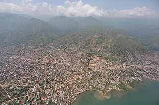
<span class="mw-page-title-main">Uvira</span> City in Democratic Republic of the Congo

Uvira is the capital city of the Uvira Territory in the South Kivu Province of the Democratic Republic of the Congo (DRC). It is situated between Lake Tanganyika and the Mitumba Mountains and covers an area of approximately 16km.

Kalemie, formerly Albertville or Albertstad, is a city on the western shore of Lake Tanganyika in the Democratic Republic of the Congo. The Lukuga River, that drains Lake Tanganyika to the Lualaba River, runs through the city. Kalemie is the capital of Tanganyika Province.

Fizi is a territory in the south of Sud-Kivu Province, Democratic Republic of the Congo, bordering the South Kivu territories of Uvira, Mwenga and Shabunda to the north, Lake Tanganyika or Tanzania in the east, and the provinces Tanganyika in the south and Maniema in the west.

<span class="mw-page-title-main">Minembwe</span> Village in South Kivu, Democratic Republic of the Congo

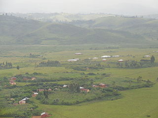
Minembwe is a cluster of several villages located in the highlands of the Lulenge, within the Fizi Territory of South Kivu Province in the Democratic Republic of the Congo (DRC). It is situated at an altitude of about 2,500 meters above sea level, in a hilly and mountainous region covered with forests, which provides fertile land for agriculture. It is approximately 150 kilometers south of Bukavu, the capital city of South Kivu. The region is also home to various streams and rivers that flow into Lake Tanganyika, the second-deepest lake in the world.

<span class="mw-page-title-main">Mulenge</span> Village in Democratic Republic of the Congo

Mulenge is a village encircled by hills in the Bafuliiru Chiefdom, located in the Uvira Territory of South Kivu Province, Democratic Republic of the Congo (DRC). It is situated on the high plateaus of the Itombwe massif, overlooking the locality of Uvira. The area has conventionally been inhabited by various ethnic groups, including the remnants of the autochthonous population of African Pygmies, as well as Bantu ethnic groups such as the Mbuti, Fuliiru, and Nyindu. The region boasts high agricultural productivity, with two harvests typically achievable each year.

<span class="mw-page-title-main">Runingo</span> Grouping in South Kivu, Democratic Republic of the Congo

Runingo, commonly known as Runingu, is one of the groupements (groupings) that constitutes the Bafuliiru Chiefdom in the Uvira Territory of the South Kivu Province in the eastern part of the Democratic Republic of the Congo (DRC). It is situated near the border with Burundi, along National Highway 5, to the north of Butaho.

<span class="mw-page-title-main">Furiiru people</span> African ethnic group

The Fuliiru people are a Bantu ethnic group predominantly inhabiting the east-central highlands of the Democratic Republic of the Congo (DRC). They reside in the South Kivu Province, situated south of Lake Kivu and to the north and northwest of Uvira Territory, along the Ruzizi Plain near the border with Rwanda and Burundi, where a contingent of Fuliiru also resides. According to the 2009 census, their population estimate exceeded 250,000, while a 1999 estimate of Kifuliiru-language speakers placed the number at 300,000. The Fuliiru are renowned for their skilled craftsmanship, particularly in the production of pottery and basketry. Their handcrafted baskets are highly coveted for their intricate designs and exceptional quality, and are frequently employed for storage, decoration, and even as musical instruments.

<span class="mw-page-title-main">Uvira Territory</span> Territory in South Kivu, DR Congo

Uvira Territory is a territory in South Kivu, Democratic Republic of the Congo. It is bordered by Walungu Territory to the north, Mwenga Territory to the west, Fizi Territory to the south, and Burundi and Lake Tanganyika to the east. Its capital is Uvira.

Muhammad bin Khalfan bin Khamis al-Barwani, commonly known as Rumaliza, was an Arab trader of slaves and ivory, active in Central and East Africa in the last part of the nineteenth century. He was a member of the Arabian Barwani tribe. With the help of Tippu Tip he became Sultan of Ujiji. At one time he dominated the trade of Tanganyika, before being defeated by Belgian forces under Baron Francis Dhanis in January 1894.

Kibanga, formerly called Lavigerieville, is a settlement in the South Kivu province of the Democratic Republic of the Congo.

Tangani'a, also known as Tanganyika, is one of the four sectors in the Fizi Territory of South Kivu Province, located in the eastern region of the Democratic Republic of the Congo (DRC). In the Bembe language (Kibembe) Tangani'a means "Tanganyika", which is the name of the major lake adjacent to the sector. It is bordered to the north by Uvira Territory and Mwenga Territory. Situated near Lake Tanganyika in the east, it is bounded to the south by the Mutambala and N’gangya sectors, and to the west by the Lulenge and Itombwe sectors.

The 2017 CNPSC offensive was a military offensive launched by rebels of the National Coalition of the People for the Sovereignty of Congo (CNPSC) on 30 June 2017 against security forces of the Democratic Republic of the Congo and MONUSCO. The goal of the offensive was to capture major settlements, mainly in South Kivu province in order to raise support for a popular uprising against then-president Joseph Kabila, who the coalition had deemed as an illegitimate president.

Lemera is one of the groupements (groupings) within the Bafuliiru Chiefdom, located in the Uvira Territory of the South Kivu Province in the eastern part of the Democratic Republic of the Congo (DRC). It is situated in the northwestern part of the Uvira Territory, approximately 60 kilometers north of Bukavu and 90 kilometers southwest of the border with Rwanda and Burundi. Lemera is in close proximity to several villages, including Kasheke, Nyambasha, Luzira, Lukayo, Kajuju, Lushasha, and Ihusi.

<span class="mw-page-title-main">Lulenge</span> Sector in the DRC

Lulenge is one of the four sectors of Fizi Territory of the South Kivu Province in the eastern region of the Democratic Republic of the Congo (DRC). It is situated near the Kiloba and Makena villages, at an altitude of 943 meters. Its capital is Kilembwe. Lulenge is bordered to the north by the Itombwe sector and Mwenga Territory. In the east, it is bordered by Lake Tanganyika and the Mutambala sector. In the south, it is bordered by the N’gangya sector, and in the west by Shabunda Territory.

<span class="mw-page-title-main">Sange, Democratic Republic of the Congo</span> Town in the Democratic Republic of the Congo

Sange is a village located in the Bafuliiru Chiefdom in the Uvira Territory of the South Kivu Province, Democratic Republic of the Congo. It is situated 24 km from the Burundian border, at 1,021 meters altitude.

<span class="mw-page-title-main">Mutambala</span> Sector in the DRC

Mutambala is a sector that constitutes one of the four sectors in the Fizi Territory of the South Kivu Province in the eastern part of the Democratic Republic of the Congo. Mutambala is situated near Lake Tanganyika, in the west by the Lulenge sector, in the north by the Tangani'a sector, and in the south by the Ngandja sector. It has a surface area of 777 km 2. The sector consists of five groupings (groupements), including the Basimukindja groupings, the Batombwe groupings, and the Babwari groupings.

<span class="mw-page-title-main">Ruzizi Plain</span> River valley in eastern Democratic Republic of the Congo

The Ruzizi Plain is a valley situated between the Mitumba mountain chain and the Ruzizi River. It serves as a natural border, separating the Democratic Republic of the Congo (DRC) from Burundi and Rwanda on the other side. The Ruzizi Plain is an integral part of the larger Western Rift Valley, which stretches across several African countries. It is traversed by the Ruzizi River, which flows from Lake Kivu through the plain and into Lake Tanganyika. It covers an area of 175,000 hectares divided between Burundi, Rwanda and the DRC. In Burundi, the plain extends to the northern sector of Imbo. It is bounded by parallels 2°36′ and 3°26′ south latitude and by meridians 29°00′ and 29°26 east longitude—an area of 1025 km2. The Congolese side is bounded to the north by the plain of Bugarama (Rwanda), to the east by the plain of Imbo (Burundi), to the West by the chain of Mitumba and to the South by Lake Tanganyika. The region covers thus about 80,000 hectares with 80 kilometers in length.

Bibogobogo, also known as Bibokoboko in Kibembe, is a village in the middle plateaus of the Mutambala Sector in the Fizi Territory in the South Kivu Province of the Democratic Republic of the Congo (DRC). It is situated in the forested mountains and middle plateaus, overlooking Baraka in the south-west, near Kisombe and Bibokoboko II villages. Bibogobogo shares the borders with Uvira Territory in the North, the Mwenga Territory and Shabunda Territory in the West, the Kalemie Territory in the South, and Lake Tanganyika in the East. The regional soil is composed of metals, including sodium, potassium, calcium, magnesium, iron, aluminium and mercury, making it suitable for gold plating, mercury pollution, pollution index and agriculture. Despite being rich in forest biodiversity, the region is in a state of poverty and insecurity which hampers any attempt at sustainable development. The ongoing ethnic conflict in the region continues to affect communities identified as Babembe, Bafuliiru, Babwari, Babuyu, Banyindu, Balega (Warega), Bamushi, and Banyamulenge.

References

  1. 1 2 3 4 5 6 7 Musengelwa, Séraphine Feza (2021). "Analyse des facteurs favorisant le mariage précoce dans le ville de Baraka, en RDC" (in French). Baraka, Fizi Territory, Democratic Republic of the Congo: Institut Supérieur de Développement Rural de Fizi. Retrieved 2023-06-13.
  2. 1 2 3 4 "Zone de Fizi : Général/Géographie physique du territoire de Fizi". mmbondo.tripod.com (in French). Retrieved 2023-11-29.
  3. 1 2 3 Michael, Chris (6 November 2014). "Missing Maps: what is Baraka ... and how can you help map it?". The Guardian . Retrieved 26 November 2015.
  4. Charles, Joseph (July 30, 2013). "Say It in English, Please!": World Language and Culture Paranoia. Bloomington, Indiana: AuthorHouse. p. 5. ISBN   9781481763899.
  5. Wolfcarius, Eveline (September 5, 2008). "UNHCR helps Congolese refugees return home across Lake Tanganyika". Unhcr.org/us/news/. Retrieved 2023-11-28.
  6. Ali-Dinar, Ali B. (ed.). "BURUNDI: OCHA Burundi Information Bulletin 16-31 May [19990607]". www.africa.upenn.edu. Retrieved 2023-11-28.
  7. "Foreign Trade in the DR Congo". Africa EENI Global Business School. Retrieved 2023-06-13.
  8. Balolage, Elisée Cirhuza; Bushenyula, Parfait Kaningu (2023-04-17), "Interconnections between War, Armed Conflict and Demonstrations in the Peri-urban Towns of Baraka and Uvira in DR Congo", Rebellious Riots, Brill, pp. 162–179, ISBN   978-90-04-54240-2 , retrieved 2023-06-13
  9. 1 2 Victor, Ekyoci Mshikana (2015). "Responsabilites societales et ethiques de la cooperative miniere de Baraka dans le development du Territoire de Fizi" [Societal and ethical responsibilities of the Baraka mining cooperative in the development of the Fizi Territory]. www.africmemoire.com (in French). Retrieved 2023-11-28.
  10. 1 2 3 David, Enoch (2020-04-09). "Monde: qui sont les Ba bembe, et voici l'histoire de cette tribu originaire du Sud-kivu". FiziMedia (in French). Retrieved 2023-11-29.
  11. 1 2 Biebuyck, Daniel P. (1982). Statuary from the Pre-Bembe Hunters: Issues in the Interpretation of Ancestral Figurines Ascribed to the Basikasingo-Bembe-Boyo (in English, French, and Dutch). Tervuren, Belgium: Royal Museum of Central Africa.
  12. Scottish Geographical Magazine: Volume 3. Perth, Scotland: Royal Scottish Geographical Society. 1887. p. 539.
  13. Foster, Anne (2018-02-22). "Des métamorphoses pour l'au-delà | Gazette Drouot". gazette-drouot.com (in French). Retrieved 2023-11-29.
  14. Lockyer, Sir Norman (1876). Nature, Volume 13. London, United Kingdom: Macmillan Journals Limited. p. 123.
  15. Littell, Blaine (1966). South of the Moon: On Stanley's Trail Through the Dark Continent. Manhattan, New York City, New York State, United States: Harper & Row. p. 189.
  16. Littell, Blaine (1966). South of the Moon: On Stanley's Trail Through the Dark Continent. Manhattan, New York City, New York State: Harper & Row. p. 189.
  17. Francis Burton, Sir Richard (1860). The Lake Regions of Central Africa: A Picture of Exploration, Volume 1. New York City: Harper. pp. 347–355.
  18. 1 2 3 4 Avec Vous nous Pouvons (2016). "Baraka". www.facebook.com. Retrieved 2023-06-13.
  19. Stanley, Henry Morton (1878). Through the Dark Continent Or The Sources of the Nile Around the Great Lakes of Equatorial Africa and Down the Livingstone River to the Atlantic Ocean, Volumes 1-2. New York City: Harper.
  20. Traveler's Guide to the Belgian Congo and Ruanda-Urundi. Brussels, Belgium: Tourist Bureau for the Belgian Congo and Ruanda-Urundi. 1956. p. 396.
  21. Richmond Wollaston, Alexander Frederick (1908). From Ruwenzori to the Congo: A Naturalist's Journey Across Africa. London, United Kingdom: J. Murray. pp. 224–225.
  22. Reports of the Missionary and Benevolent Boards and Committees to the General Assembly of the Presbyterian Church in the United States of America. Louisville, Kentucky: Presbyterian Church in the U.S.A. 1917.
  23. Board of Trade Journal: Volume 86. London, United Kingdom: H.M. Stationery Office. 1914. pp. 760–761.
  24. Hudson, Andrew (July 19, 2012). Congo Unravelled: Military Operations from Independence to the Mercenary Revolt 1960–68. Warwick, England: Helion Limited. ISBN   9781909384330.
  25. Delmas, Adrien; Bonacci, Giulia; Argyriadis, Kali, eds. (November 2020). Cuba and Africa, 1959-1994: Writing an Alternative Atlantic History. Johannesburg, South Africa: Wits University Press. ISBN   9781776146352.
  26. Photos, MONUSCO (2022-02-28), PHOTO DU JOUR DU LUNDI 28 FEVRIER 2022 , retrieved 2022-02-28