International relations
Twin towns and sister cities
Bagira is twinned with:
Bagira is one of the communes in Bukavu, South Kivu in the Democratic Republic of the Congo. [1] [2] Thousands of displaced people arrived there in the early 2000s as a result of the conflict (Congo wars) in the eastern Democratic Republic of the Congo, [2] and it was stated that it was "not uncommon" at the time for "twenty or more people there to share one small house". [2]
Bagira is twinned with:

South Kivu is one of 26 provinces of the Democratic Republic of the Congo (DRC). Its capital is Bukavu.

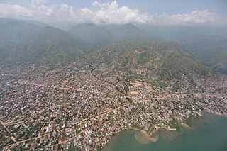
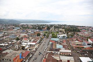
Bukavu is a city in eastern Democratic Republic of the Congo (DRC), lying at the extreme south-western edge of Lake Kivu, west of Cyangugu in Rwanda, and separated from it by the outlet of the Ruzizi River. It is the capital of the South Kivu Province and as of 2012 it had an estimated population of 806,940.
Karisimbi is a commune of the city of Goma in the North Kivu Province of the eastern region of the Democratic Republic of the Congo. It is named after the nearby Mount Karisimbi.

Kivu was the name for a large "region" in the Democratic Republic of the Congo under the rule of Mobutu Sese Seko that bordered Lake Kivu. It included three "Sub-Regions" : Nord-Kivu, Sud-Kivu and Maniema, corresponding to the three current provinces created in 1986. The capital of the Kivu Region was in Bukavu, and the capitals of the three Sub-Regions were in Goma, Uvira and Kindu.
Uvira is a city strategically located in the South Kivu Province of the eastern region of the Democratic Republic of the Congo. Covering approximately 16 square kilometers and with an estimated population of 726,000 as of 2024, it borders Bafuliru Chiefdom and Ruzizi Plain Chiefdom to the north, Bavira Chiefdom to the south, and Lake Tanganyika and the Ruzizi River to the east. These rivers form natural boundaries between the DRC and Burundi. Located in the Ruzizi Plain at a low altitude, the city lies between Burundi's Congo-Nile ridge and the Mitumba mountains.
The Roman Catholic Archdiocese of Bukavu is the Metropolitan See for the ecclesiastical province of Bukavu in the Democratic Republic of the Congo.
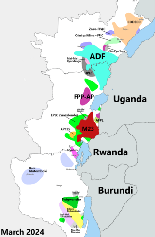
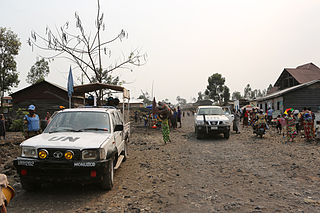
The Kivu conflict is an umbrella term for a series of protracted armed conflicts in the North Kivu and South Kivu provinces in the eastern Democratic Republic of the Congo which have occurred since the end of the Second Congo War. Including neighboring Ituri province, there are more than 120 different armed groups active in the eastern Democratic Republic of Congo. Currently, some of the most active rebel groups include the Allied Democratic Forces, the Cooperative for the Development of the Congo, the March 23 Movement, and many local Mai Mai militias. In addition to rebel groups and the governmental FARDC troops, a number of national and international organizations have intervened militarily in the conflict, including the United Nations force known as MONUSCO, and an East African Community regional force.
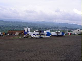
Kavumu Airport is an airport serving Bukavu, the capital city of the Sud-Kivu province in the Democratic Republic of the Congo. The airport is 25 kilometres (16 mi) north of Bukavu.

Pierre Lumbi Okongo Born in Costermansville, Belgian Congo (11 March 1950 – 14 June 2020) was a Congolese activist, politician, and opposition leader. He was a prominent figure in the political landscape of the Democratic Republic of the Congo (DRC), known for his involvement in opposition movements and his role in advocating for political change.
Kadutu is a commune in Bukavu, South Kivu, Democratic Republic of the Congo.
Goma is a commune of the city of Goma in the North Kivu Province of the eastern region of the Democratic Republic of the Congo. It encompasses the southernmost sector of the city, extending from the principal main road towards the shores of Lake Kivu. As per a 2018 estimate, the commune had approximately 333,727 residents.
Luberizi is a village located in the Luvungi groupement within the Bafuliiru Chiefdom of Uvira Territory, South Kivu Province, in the eastern region of the Democratic Republic of the Congo. At an elevation of 957 meters, it has a local population of about 25,462. It sits astride the N5 road where it crosses the Luberizi River, nearly midway between Uvira to the south and Bukavu to the north. The village of Mutarule, the scene of the 2014 South Kivu attack, is located nearby.

A magnitude 5.8 earthquake struck the Democratic Republic of the Congo 35 km (22 mi) north northeast of Kabare, South Kivu on August 7 at a depth of 11.0 km (6.8 mi).

The Our Lady of Peace Cathedral or simply Cathedral of Bukavu, is a religious building of the Catholic Church which is located in the city of Bukavu in the east end of the African country of the Democratic Republic of the Congo, specifically in the province of South Kivu.
The following is a timeline of the history of the city of Bukavu, Democratic Republic of the Congo.
Kasha is a periurban area of the city of Bukavu. It is located northwest of the city center on Lake Kivu. With the advent of the Rally for Congolese Democracy (RCD), Bukavu grew from three to four communes. The commune of Kasha was created from an urban-rural district of the commune of Bagira. In the present day it is no longer a commune.

The Festival Amani is an annual festival that takes place in the context of peacebuilding in the Democratic Republic of Congo and the Great Lakes region. Amani is the Swahili word for Peace.

In early 2022, heavy rain caused large floods to hit the city of Bukavu, South Kivu, Democratic Republic of the Congo.

Théo Ngwabidje Kasi is a politician from the Democratic Republic of the Congo who is the Governor of South Kivu Province since 9 April 2019. He is a member of the Union for Democracy and Social Progress

Kamanyola is one of the groupements (groupings) within the Ngweshe Chiefdom of the Walungu Territory. It is located in the Ruzizi Plain in the South Kivu Province of the Democratic Republic of the Congo (DRC), sharing a border with Rwanda and Burundi. Kamanyola stands at a height of 901 meters and is closely situated to the suburb of Mwaro and the village of Mubombo.
| Cities and communes |
| ||
|---|---|---|---|
| Territories | |||
| Populated places |
| ||
| Other | |||
| | This Democratic Republic of the Congo location article is a stub. You can help Wikipedia by expanding it. |