The precise meaning or origin of the name Luvungi is not explicitly specified in the colonial records. According to a report published by the International Documentation Network on the African Great Lakes Region (Réseau documentaire international sur la région des grands lacs africains) for Uvira Territory, the name could be a regional adaptation or modification of another name, as it was derived from a Belgian colonial misinterpretation of the river Luvubu, although its authentic designation was Lyombe.[7]
Geography
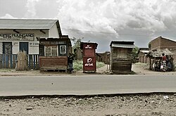
The Ruzizi River originates in Lake Kivu and flows into Lake Tanganyika, passing through several regions, including some of the most well-known areas of South Kivu. This image shows the river as it passes through Luvungi, in the Bafuliiru Chiefdom, within the Ruzizi Plain.
Luvungi is situated within the Ruzizi Plain, a vast low-lying region characterized by its fertile soils and extensive agricultural productivity. The plain extends between the Mitumba mountain range to the west and the Ruzizi River to the east, forming a significant agricultural zone in the eastern Democratic Republic of the Congo.[5] The topography of Luvungi features two main relief zones: the eastern plains, which lie at elevations ranging from approximately 700 meters along the Ruzizi River, up to about 3,500 meters near the Mitumba Mountains in the west, and the western plateaus.[5] The area's soils are diverse, including sandy, gravelly, black alluvial, and clayey types. This soil diversity supports cultivation of crops such as peanuts, maize, cotton, rice, and others.[5] Hydrologically, Luvungi is traversed by the Ruvubu River, which feeds into the Ruzizi River, and by the Munyovwe River, a tributary of the Ruvubu. Historically, the Munyovwe River provided drinking water for local inhabitants until a formal water supply system was established in 2005.[5] The region's vegetation comprises grassysavannahs and gallery forests, which support pastoral activities and livestock domestication.[5] Luvungi has historically served as a transhumance route for pastoralists from neighboring regions, including Burundi and Rwanda, occasionally leading to community conflicts over land and resources.[5]
Climatically, Luvungi experiences a tropical climate with a distinct seasonal pattern, featuring a rainy season lasting approximately nine months from September to May, and a dry season spanning June to August.[5] The average annual rainfall is around 940 millimeters,[5] though it can be as low as 600 millimeters per year, with distribution issues affecting agricultural productivity.[2]
Government and administrative division
Mwami Nyamugira Mukogabwe II of the Bafuliiru Chiefdom, circa 1925 in Nia Magira (Lemera). Seated at the center, he is adorned in traditional attire, holding a staff that signifies his authority.
The Luvungi groupement is governed by a chef de groupement (grouping chief) who serves as the primary local authority and representative of the paramount Mwami of Bafuliiru Chiefdom.[5] The Mwami retains traditional control over the land within the chiefdom, asserting ownership in accordance with customary law, a practice that diverges from the constitutional provisions of the Democratic Republic of the Congo, which affirms that private property rights are guaranteed by the state (as per Article 34 of the Constitution).[5] While the state legally manages land rights and property, customary authorities, including the Mwami and the chef de groupement, play a significant role in local land affairs, often collaborating with state authorities despite occasional conflicts over land jurisdiction and authority.[5]
The chef de groupement is a hereditary position, descending from the Mwami, and holds authority over the area, exercising both administrative and customary functions. He is supported by a council of elders, who provide counsel and ensure that customary law is upheld.[5] The chef de groupement oversees local governance, justice, and conflict resolution within his jurisdiction, delegating judicial authority to local trial leaders for minor cases, while more serious legal matters are handled directly by the Mwami.[5]
The Luvungi groupement is subdivided into smaller units known as villages (localités), each headed by a chef delocalité (also known as chef de village), who acts as the local representative of the chef de groupement. The chef de village plays a crucial role in customary and local governance, serving as a protector, judge, and manager within his village.[5] While some chefs de village are traditional chiefs, others may be appointed based on expertise.[5] Below them, a chef de sous-village (or chef de quartier) assists the chef de village in carrying out functions such as tax collection and local administration.[5] Additionally, the role of chef de colline (hill chief) exists within the hierarchy; this position is considered a distinct chiefdom, appointed by the chef de village, and involves customary rituals of respect, such as offering a goat and a jug of drink to acknowledge authority.[5]
Post and village of Luvungi, Belgian Congo, ca. 1928
Prior to the colonial period, the Bafuliiru Chiefdom was under the reign of Mwami Kalingishi, a member of the Bahamba clan of Fulliru people. As the king, Kalingishi held significant authority, and all power was concentrated within the ruling family. This consolidation of power extended to the various groups known as "Baluzi".[7] Until 1904, Itara-Luvungi was under the administration of Territory of Ruzizi-Kivu (Territoire de Ruzizi-Kivu), which was governed by the Congo Free State.[8][9][10] The region was situated strategically close to the short land border between the Belgian Congo and German East Africa until World War I. On 12 January 1915, Luvungi was raided by German forces as part of the ongoing campaign in East Africa. Although a relatively small-scale operation, the skirmish resulted in German defeat by the Belgian Force Publique, and the German commander, Karl Schimmer, was killed.[11]
In 1920, a post was officially established at Luvungi under J. Cunds. Thereupon, negotiations took place between Chief Kabwika and the territorial authorities to address administrative challenges. The newly established post witnessed rapid stability and progress. Infrastructure development, including road construction, attracted settlers from the middle and high plateaus to the Ruzizi Plain.[5][12][13][14] The Belgian administration subsequently established chiefdoms as a part of their administrative system under the policy of indirect rule. Luvungi became a part of the Bafuliiru Chiefdom, which was created in 1928.[7] In the 1950s, ethnic conflict emerged between the Bafuliiru and Burundian populations, with notable figures such as Moïse Marandura, a Fuliru leader, playing a central role in the conflict.[15] Following Congo's independence in 1960, political violence resurfaced around 1963 when armed clashes broke out between militants of the Mouvement National Congolais (MNC), led by Marandura, and those of the Parti National Populaire (PNP), in an episode known as the Mulelist or Kwilu Rebellion, during which Luvungi served as a rear base for government forces.[15]
Customary power
Early leadership and the reign of Kabwika (1912–1920)
The customary authority has historically been held by traditional rulers known as Bami (plural of Mwami), whose leadership spans several generations. The first officially recognized mwami of Luvungi was Kabwika, who reigned from 1912 to 1920, during a period when the groupement was known as the Luvuluga Chiefdom (Chefferie de Luvuluga) due to its proximity to Kaziba Chiefdom.[16] Appointed by the Belgian colonial administration and son of former Nyamugira, Kabwika's rule was marked by significant demographic changes, particularly the influx of Burundian migrants into the Ruzizi Plain. This movement triggered longstanding land disputes, exacerbated by Kabwika's resistance to foreign encroachment, which eventually led to his deportation to Rutshuru.[16] His temporary replacement by Chief Makora, who then facilitated further Burundian settlement in the region.[16] During Kabwika's reign, the groupement comprised 25 localités, which were effectively managed through a collaboration between the Belgian colonial authorities and local chiefs:[16]
The reign of Mbabaro and the colonial era developments (1920–1937)
Kabwika was succeeded in 1920 by his son Mbabaro, whose administration maintained close cooperation with colonial authorities. His reign was marked by relative stability and the development of early economic infrastructure, including initiatives such as a pioneering railway project intended to connect Lake Tanganyika to Lake Kivu.[16] This infrastructure facilitated population movements from the middle plateaus to the Ruzizi Plain and encouraged the settlement of European entrepreneurs, notably Mr. Stravoulakis, who established himself in Luvungi in 1926 and became among the first to engage in commercial and pastoral activities within the region.[16] In 1937, Mwami Mbabaro died at a time when his heir, Kimbumbu, was only eight years old. Consequently, a regency was established, with Mr. Makora, a village chief appointed by local elders, assuming authority. The period of regency was marked by instability; Makora was accused of abusing his power, which led to a decline in effective governance.[16] During this time, incidents of cattle theft increased, worsening existing local conflicts, while the mwami was reported to have spent much of his time inebriated. A succession of minor chiefs, known as "little bami", held power in quick succession until the emergence of a more prominent leadership figure:[16]
No.
Mwami
Reign period
Key facts
1
Kabwika
1912–1920
The migrations of the Barundi people and the subsequent establishment of competing identities.
2
Mbabaro
1920–1937
Relative stability under Belgian colonial administration, with the region coming under firm control, leading to the establishment of the first commercial enterprises that facilitated economic development and trade, as well as the undertaking of significant infrastructural projects, notably the construction of a railway connecting Lake Tanganyika to Lake Kivu.
3
Makora
1938–1941
Significant instability characterized by tumultuous regencies, with widespread reports of abuses against citizens including acts of violence and misconduct by those in authority, as well as cattle thefts and other forms of local conflict playing a role in the overall disorder and unrest within the region.
4
Mugombekere
1941–1945
The emergence of Kimbumbu as the holder of customary rights occurred following pressure from local notables.
5
Kimbumbu
1945–1955
Relative peace and a revival of economic activities: construction of a strategically important airfield was undertaken, serving both military and logistical purposes.
6
Mutanga
1955–1969
Period of regency: attempt to rename the groupement, changing its designation from the Luvuluga groupement to Itara-Luvungi, a time marked by political turbulence notably with the infiltration of Pierre Mulele's rebellion into the region, which became intertwined with local conflict dynamics and was further exacerbated by Lumumbist youth led by Moise Marandura, who were responsible for initiating significant unrest that contributed to heightened instability and social tensions during this time.
7
Ombeni Kimbumbu II
1969–1976
Phase of stabilization following the years of Mulelist insurgency and conflict.
8
Shalupa Kaliw
1976–1977
Brief regency.
9
Ndare Oyo
1977–1990
Stable period: construction of schools, clinics and roads.
10
Ombeni Kimbumbu II (Second reign)
1991–1995
Rapidly poisoned, leading to his replacement by Mbambaro.
Kimbumbu's era, post-war growth, rebellion, and political change (1945–1990s)
Kimbumbu's reign (1945–1955) coincided with the post–World War II era, during which significant developments occurred in the region. Notably, the construction of the Luvungi airfield was undertaken; this runway played a crucial role in Belgian military operations and was also utilized for transporting light agricultural equipment to Luvungi. Additionally, the expansion of cotton cultivation marked an important economic development during this era.[16] Following Kimbumbu's death in 1955, the region entered a period of regency and instability, which was also compounded by the broader political upheavals that followed Congolese independence in 1960. The area became a site of conflict wherein the Pierre Mulele's rebellion gained influence and support among some local notables.[16] Simultaneously, Lumumbist youth, led by Moise Marandura, engaged in acts of unrest, including theft, rape, and looting. The region experienced continued turmoil, notably during the 1964 rebellion and the events involving Jean Schramme in 1967.[16] Subsequently, President Mobutu Sese Seko implemented measures to stabilize the country. During this period, the Ruzizi Plain enjoyed a relatively peaceful and stable phase.[16] Between 1969 and 1977, leadership within the local customary authority was held successively by two chief: Ombeni Kimbumbu II and Shalupa Kawila. The latter, appointed by the Uvira zone commissioner, faced opposition from the local population and was eventually replaced. In 1990, Chief Ndare Oyo succeeded him as the traditional leader of the region.[16]
Ndare Oyo's prosperous reign and the challenges of the late 1990s
Chief Ndare Oyo ascended to the throne at the age of 23. His reign was characterized by prosperity and a focus on educational development. He promoted the construction of schools across various villages, facilitated the establishment of health centers, and actively supported cotton cultivation.[16] He maintained the throne until the return of Mwami Ndare Simba; however, Ndare Nsimba did not assume the throne. According to customary practices, traditional authority was not hereditary from brother to brother.[16] Ombeni Kimbumbu was reinstated as chief for a second term but died four years later due to poisoning.[16] Subsequently, the regency was entrusted to Chief Bikoba, who was responsible for caring for the young Prince Joseph Mbabaro Ombeni. This period was also marked by ongoing political instability within the community.[16]
From the late 1990s onward, Luvungi entered a prolonged period of contested leadership, shaped by internal dynastic disputes, civil conflict, and armed group interference. In 1996, Ndaye Kimbumbu, son of Kimbumbu, was appointed as regent for the young heir, Joseph Mbabaro Ombeni.[16] However, his regency was challenged by internal factions, particularly following the arrival of the Rassemblement Congolais pour la Démocratie (RCD) rebel movement on 2 August 1998. The rebel incursion intensified opposition to Chief Ndaye, ultimately forcing him into exile in Kinshasa.[16] During this period, a power struggle emerged between Regent Ndaye and Prince Joseph Mbabaro Ombeni, who sought to assert his claim to leadership. The conflict was also complicated by the fact that both figures belonged to the same royal lineage.[16] Several influential members of the groupement formed coalitions aimed at deposing the regent. Due to the young prince's inexperience and the regent's forced absence, governance of the groupement was left in a state of uncertainty.[16] In an effort to restore order, members of the royal family and traditional council intervened. Ndanoga, the paternal uncle of Prince Mbabaro, was appointed as interim chief.[16] Subsequently, on 7 August 1998, Mwami Simon Ndare Simba II, in consultation with the council of elders, proposed the appointment of Levis Kagombe, a cousin of Mwami Ndare, as chief of the Luvungi groupement. Kagombe served from 1998 to 2001. According to Fuliiru historian Innocent Bihundo Kityaba, Ndanoga remained influential until 2004.[16] However, Kagombe's rule faced significant internal opposition. Of the 29 prominent notables, 24 reportedly rejected his authority, asserting that Kagombe did not belong to the reigning dynasty. In retaliation, Kagombe dismissed several notables suspected of leading this opposition.[16] Prince Joseph Mbabaro, enjoying strong support from the notables, mobilized efforts to displace Kagombe. On 7 March 2001, Kagombe was killed by Mai-Mai militias, amid renewed efforts by Ndaye to reclaim power. The Mai-Mai had initially supported Mbabaro in removing Kagombe, but relations deteriorated when the prince allegedly violated their agreements, particularly by refusing to expel individuals the Mai-Mai considered infiltrators.[16] In the aftermath, the Mwami appointed an interim chief, Bwenge, who did not belong to the royal lineage. His administration lasted only two days, as he was assassinated by the Mai-Mai. It is noted that some local leaders had aligned with the Mai-Mai resistance, opposing what they perceived as a regency sympathetic to occupying rebel forces.[16]
Prince Joseph Mbabaro's rule, Chief Ndaye's second regency, and the succession dispute
Prince Joseph Mbabaro subsequently returned to Luvungi and reclaimed power, ruling from 2001 to 2003. His tenure was marked by instability, lawlessness, and allegations of sexual violence, leading to his suspension and replacement by Dunia Fandi Kimbumbu.[16] Dunia Fandi (2004–2008), a member of the royal dynasty noted for his strength and wisdom, attempted to reconcile the fragmented population. However, his efforts were undermined by renewed opposition from Mbabaro, who organized a Mai-Mai militia to destabilize Fandi's administration.[16] Eventually, Fandi was deposed, and Ndaye Kimbumbu returned to power for a second time.[16]
Chief Ndaye resumed leadership of the Luvungi groupement in 2008, serving until 2012. His return was marked by persistent conflicts with Prince Joseph Mbabaro Ombeni. According to Bafuliiru custom, Mbabaro's father, Ombeni Kimbumbu, was the legitimate traditional chief, a fact that reinforced the son's belief in his own rightful claim to leadership.[16] However, Mbabaro's youth at the time of earlier power transitions had prevented him from assuming authority, which fueled his frustration and jealousy as others occupied the throne.[16] Despite initial tensions, Chief Ndaye attempted to restore traditional legitimacy by endorsing Mbabaro as his successor, in accordance with customary law. He also paid tribute to his elder brother Ombeni, who had disappeared in 1995. Nonetheless, Prince Mbabaro began to act in open defiance toward Mwami Simon Ndare Simba II and engaged in actions perceived as detrimental to groupement unity.[16] The Mwami and the council of elders attempted mediation, setting specific conditions for Mbabaro to ascend to leadership. In 2012, certain territorial authorities were summoned to witness the formal handover of power.[16]
Mbabaro's reign, rising tensions, political rise, and renewed succession crisis
Joseph Mbabaro Ombeni officially assumed leadership of the groupement in 2012. Born to Ombeni Kimbumbu II and Antoinette Yowari, he lacked the full endorsement of Mwami Ndare, which hindered his authority. His tenure was marked by growing unrest, particularly in Lubarika and the northwestern parts of the groupement, which were under the control of Mai-Mai militia groups.[16] These militias purported to defend the chiefdom but were suspected of maintaining links with Chief Mbabaro. Tensions escalated when the Mai-Mai turned against Mbabaro, accusing him of associating with unknown individuals they regarded as infiltrators.[16] This development contributed to the destabilization of the region and led to Mbabaro's temporary exile in Bukavu, where he awaited mediation efforts aimed at reconciling him with the local armed factions. During his absence, the groupement lacked effective leadership.[16] Upon his return, Mbabaro sparked another controversy by opposing a local initiative to elevate Luvungi to the status of a commune, a stance that many perceived as self-serving. His reign was also marred by serious allegations, including the illegal sale of farmland, such as the Kindobwe marsh.[16] This transaction was met with strong resistance from civil society and the population, who, with the support of national deputy Mulimbalimba, reclaimed the land.[16]
Following the 2018 provincial elections, Joseph Mbabaro Ombeni was elected as a provincial deputy representing Uvira Territory under the banner of the People's Party for Reconstruction and Democracy (PPRD).[17][18] After his election, his family unilaterally notified the provincial governor that his sister, Antoinette Mbabaro, would succeed him as chief of the groupement. However, this decision was challenged in May 2019 when Mwami Adams Ndare III Simba Kalingishi appointed Maisha Ombeni as the new traditional chief, bypassing the Mbabaro family's designation.[17][18] This competing appointment reignited longstanding tensions, dividing the community into rival factions: one aligned with the Mwami's authority, and the other loyal to the Mbabaro lineage.[17][18] Violence erupted during Maisha Ombeni's enthronement ceremony, during which eight people were injured.[17][18][19] Supporters of the Mbabaro family blocked the Luvubu Bridge to prevent Mwami Kalingishi and Deputy Mulimbalimba from accessing Luvungi for the official installation.[19] Police forces intervened, and security was reinforced with the arrival of three FARDC military jeeps, allowing the ceremony to proceed.[19]
In 2020, further controversy arose involving Deputy Mbabaro and the Catholic education authorities in Luvungi. The local Catholic school coordination filed a complaint accusing him of supporting a militia allegedly responsible for local insecurity and intimidation, including threats against Father Joseph Musafiri and Cizungu Machane, the principal of the Umoja/Katogota Institute.[20] Mbabaro denied all accusations, characterizing them as unfounded and defamatory, and stressed that he could not be held accountable for the criminal actions of others. He cited the Congolese Penal Code and the national Constitution in his defense and warned of potential legal action against continued personal attacks.[20] Joseph Mbabaro Ombeni died on 5 August 2021 in Bukavu due to complications related to COVID-19.[21]
Demographics
Luvungi is a demographically diverse, primarily inhabited by the indigenous Fuliru people who occupy the Ruzizi Plain and the surrounding middle and upper plateaus, while also hosting significant communities of Burundian origin, often described as immigrant or transborder populations, which have historically been a source of tension and conflict.[5] Aside from these groups, there are also other Congolese ethnic communities, such as the Bashi, Babembe, Barega, Banyindu, and Bavira. While the Fuliru constitute the leading group, the population generally maintains peaceful relations with non-native communities, except for intermittent conflicts with Burundian populations, often worsened by regional political and socio-economic factors linked to regimes from Rwanda and Burundi.[5]
A portion of the Luvungi's population originates from the high plateaus of Bafuliiru Chiefdom, while another portion consists of BurundianHutu migrants who crossed into the area in search of agricultural land and employment opportunities.[15] Historically, the first foreigners to settle in Luvungi were Arab-Swahili traders engaged in regional commerce, followed by German traders arriving from Burundi, who established trading relations before clashing with the Arab-Swahilis in local skirmishes.[15]
Formal education began during the colonial period with the establishment of the first school in 1930, designed as a literacy and vocational training center to produce skilled laborers, including cooks, sentinels, agricultural monitors, clerks, soldiers, and municipal functionaries, to serve the colonial administration.[7] As of 2016, Luvungi hosts more than 45 primary and secondary schools, comprising Catholic, Protestant, and government-operated institutions.[5] The healthcare system was similarly introduced during the colonial era, with the earliest rural dispensary founded around 1940 by Catholic missionaries. The current healthcare infrastructure includes three hospitals: Luvungi I, Luvungi II, and Mirungu, alongside two health posts (COMICO and Methodist), and one private dispensary.[7][5] Multiple private and faith-based health clinics also serve the area.[5] Religiously, the area is home to 29 churches affiliated with the 8th CEPAC (Communauté des Églises de Pentecôte en Afrique Centrale), as well as Catholic, Adventist, Anglican, Methodist, and other Christian denominations.[5]
Historically, blacksmithing constituted a significant artisanal craft, as locally forged Fuliiru hoes and other iron tools were traditionally exchanged for ornamental beads imported from Burundi.[22] However, this trade has not undergone modernization and remains largely confined to small-scale, manual production.[22]
Luvungi, like other regions in the Ruzizi Plain, has been confronted with various conflicts and security challenges. It has been significantly affected by the presence of various armed groups, encompassing both local militias and foreign factions. On 20 October 1996, during the First Congo War, Luvungi experienced a massacre when the Alliance of Democratic Forces for the Liberation of Congo-Zaire (AFDL), Rwandan Patriotic Army (RPA), and Forces Armées Burundaises (FAB) units targeted the refugee camps in the Bafuliiru Chiefdom. Approximately 100 Burundian and Rwandan Hutu refugees were killed in Luvungi refugee camps. On the same day, the AFDL, APR and FAB units also killed an unknown number of refugees, including around twenty in the camp's hospital in Kanganiro camp in Bafuliiru Chiefdom. Additionally, they targeted and killed an unknown number of refugees who sought shelter in the homes of Zairean civilians in Luvungi.[23][24]
Moving forward to 21 October 1996, AFDL, RPA, and FAB forces resumed their violence, killing an unknown number of Rwandan and Burundian refugees, as well as Zairean civilians who were attempting to flee the groupement after the departure of the Zairian Armed Forces (FAZ) in Lubarika village, located in Luvungi. The soldiers forced local residents to bury the bodies in four large mass graves. On the same day, around 370 refugees were killed in Luberizi and Mutarule by the units of the AFDL, RPA, and FAB. The victims' bodies were disposed of in pit latrines, while others were discovered in houses in the two towns.[23]
In the Second Congo War, with the emergence of the Rally for Congolese Democracy (Rassemblement Congolais pour la Démocratie; RCD), conflicts in the Ruzizi Plain escalated following the power shift and the coalition formed by the Banyamulenge and Barundi against the Bafuliiru, particularly in Luvungi and Sange.[24] The RCD forces took control of certain provincial mineral resources, leading to a swift military operation to plagued regions in the Ruzizi Plain as well as in Walungu Territory, Kabare Territory, Kalehe Territory, and Shabunda Territory. Luvungi and its surrounding areas experienced numerous casualties, displacement of locals, and a large-scale exodus of people seeking refuge in the middle plateaus of Luvungi.[24] In 1998, the RCD attempted to undermine the authority of traditional rulers, targeting the bami, who resisted these efforts. Their resistance contributed to the radicalization of local populations against the RCD.[25] By 1999, the RCD adopted a policy of incorporating mwami into its administrative framework to maintain a semblance of local legitimacy. During the national transition period (2003–2006), traditional authorities in RCD-controlled areas played a pivotal role in fostering stability and facilitating the transition toward national reconciliation.[25]
Between 2000 and 2003, a Mai-Mai militia group originating from Kitanda mobilized to defend the local population. They established a base in Kabingu, within Luvungi. This militia, operating in the mid-altitude plateau, was commanded by General Ruharara, who was noted for his military organization and leadership.[25] Ruharara mobilized local leaders and social groups for a unified resistance and launched a recruitment drive, delegating responsibilities to Colonel Ndafura, Major Kizingati, and a commander known as Abdou. Other Mai-Mai elements, such as those under Kayamba Kihumbi in the Lemera groupement, came under frequent attack from RCD forces.[25] In 2003, General Ruharara convened a general assembly in Buheba, located in Katembo, bringing together Mai-Mai factions from across the province. The assembly lasted two weeks and reportedly hosted around 800 fighters per day. Its main objective was the liberation of South Kivu, with a specific focus on the Luvungi groupement. The RCD, in response, formed a militia to disrupt the gathering, although it failed to dismantle the assembly.[25] The Mai-Mai maintained their cohesion, bolstered by traditional spiritual practices and cultural beliefs. The Mai-Mai militia in the Ruzizi Plain continued resisting the RCD until 2003 when the Sun City Agreement marked the official end of the Second Congo War.[25]
Ongoing insecurity problems
Women of Luvungi, June 2016
Following the official end of the war in 2003, insecurity persisted in Luvungi and surrounding areas. On 15 December 2005, 155 people, including 44 civilians from the Luvungi assembly camp, were repatriated to Rwanda through the Bugarama border by the United Nations Mission in the Democratic Republic of Congo (MONUC) through its Disarmament, Demobilisation, Repatriation, Reintegration and Resettlement (DDRRR) program.[26] This repatriation, which began in October 2005, marked one of several waves that included former Rwandan Hutu rebels and their dependents.[26] By early 2006, another group of 15 Rwandan Hutu rebels had returned to Rwanda, while 350 dependents were being held at a refugee assembly point in Sange.[27] Luvungi remained a hotspot for armed conflict in the following years. In July 2009, the Armed Forces of the Democratic Republic of the Congo (FARDC) clashed with Democratic Forces for the Liberation of Rwanda (FDLR) rebels entrenched in Murunga, four kilometers from Luvungi.[28] The confrontation was part of ongoing military operations targeting remaining pockets of FDLR resistance in the Ruzizi Plain. The FDLR had been regrouping in the area in an attempt to cross into neighboring Burundi.[28] FARDC troops arrested two attackers during the engagement. FDLR activity was also reported in nearby localities such as Ndolera, Lubarika, and Kigushwe, though these remained under FARDC control.[28]
In September 2009, internal divisions within the FARDC further destabilized Luvungi. A power struggle emerged between the 33rd and 109th brigades over control of Operation Kimia II, a joint military operation aimed at neutralizing FDLR forces.[29] The 33rd brigade, newly deployed from North Kivu and reportedly unpopular among the local population, attempted to assume leadership of the operation. In response, the 109th brigade, which had formal command, resisted.[29]Miscommunication and mutual suspicion led to armed clashes between the two units on two separate nights. Military sources suggested that the first incident may have been triggered by a fire at the local market, mistakenly believed to be an FDLR attack.[29] The infighting resulted in the arrest of 11 FARDC soldiers in December 2009, and the demobilization of three child soldiers who were subsequently handed over to MONUC's Child Protection Section in Uvira.[30][31] In April 2010, students staged protests against ongoing insecurity, blocking the Bukavu-Uvira road near Luvungi after a family was attacked by armed men, leaving two people injured.[32] FARDC troops fired into the air to disperse the demonstrators and restore order.[32] Between 27 and 28 March 2010, five people were murdered in the territories of Kabare, Mwenga, and Uvira. Among the victims were a soldier, the president of a civil society group, and a local chief.[33] In Luvungi, two men were killed at point-blank range by unidentified armed men, while in other regions, attacks were attributed to FDLR combatants.[33]
A group of women gathered inside a modest classroom in Luvungi
An outdoor mobile court hearing organized in Luvungi supported by MONUSCO's Justice Support Section.
In May 2011, Luvungi witnessed violent protests organized by civil society groups, farmers, and herders against a former chef de groupement accused of land mismanagement, illegal land sales, and militia activity.[34] The protests escalated into violence when the former chief allegedly dispatched youths to confront demonstrators, leading to four injuries. Though territorial authorities had suspended him two months earlier, he reportedly refused to cede power and maintained an armed group to oppose his successor.[34] National and military police forces were deployed to maintain order.[34] In response to broader regional insecurity, FARDC reinforced its presence in Luvungi. On 30 August 2011, additional troops were deployed to Lubarika after armed men looted the area and stole livestock.[35] In May 2012, the National Commission for Refugees (Commission Nationale pour les Réfugiés; CNR) launched a sensitization campaign targeting military and civilian authorities in Kamanyola and Katogota, aiming to encourage the voluntary repatriation of Burundian refugees residing in Uvira Territory.[36] Later, in November 2012, DDRRR and the United Nations High Commissioner for Refugees (UNHCR) repatriated four former FDLR members and two Rwandan civilians, including one from Luvungi, to Rwanda.[37]
In May 2013, security concerns were exacerbated when a 12-year-old girl was killed during an exchange of fire between soldiers and armed men in Luvungi.[38] The following year, in March 2014, Luvungi faced a humanitarian crisis when nearly 4,000 displaced families arrived from Bwegera after the murder of two people in that village.[39][40][41] The influx worsened pre-existing housing shortages, particularly after the collapse of 400 houses due to heavy rains two months prior. Displaced families reported living in incomplete structures without doors or windows and receiving no assistance, often sleeping on mats in unsanitary conditions.[39] On 6 June 2014, a massacre occurred in the village of Mutarule, where 36 people—primarily from the Bafuliiru community—were killed, some by gunfire and others by being burned alive. The event occurred despite repeated warnings issued by residents to both the United Nations Mission in the Democratic Republic of Congo (MONUC) and the Congolese armed forces.[25] The lack of response prompted public outcry, leading Martin Kobler, then head of MONUC, to issue a formal apology. The Congolese government initiated an investigation, and approximately 5,700 displaced persons demanded the restoration of security in the area.[25] The resulting power vacuum and ongoing instability were exploited by various groups to perpetrate further violence, looting, and theft. Among the key figures during this period was a Mai-Mai commander known as Bede, who initially presented himself as a patriot but was later exposed as a central instigator of armed robberies and violent unrest throughout the Ruzizi Plain.[25] Following continued destabilization efforts, Bede was ultimately killed by gunfire in Uvira on 29 August 2015. His death marked the beginning of a relative period of calm in the region,[25] but intercommunal tensions in the Ruzizi Plain, particularly in Mutarule, persist. Disputes between the Bafuliiru, who consider themselves the indigenous population, and the Barundi, often perceived as newcomers, strained their relations and complicate peacebuilding efforts.[25] In September 2022, six members of the Mayï-Mayï Buhirwa militia, including the group's second-in-command, Mathias Byamungu Demahyi, surrendered to the FARDC in Luvungi.[42] These fighters, active in the region between the Ruzizi Plain and the plateaus of Kigoma and Lemera groupements, turned over a cache of weapons, grenades.[42] Their surrender followed that of another senior figure in the group, Ndumwe Kahiri Noir, who had laid down arms three weeks earlier at MONUSCO's DDRRR center in Uvira.[42]
↑Depelchin, Jacques (1974). From Pre-capitalism to Imperialism: A History of Social and Economic Formations in Eastern Zaire. Stanford, California, United States: Stanford University. pp.87–94.
1234567891011Kityaba, Innocent Bihundo (20 January 2016). "Chap III. Évolution politique d'Itara après 1996"[Chapter III. Political evolution of Itara after 1996] (in French). Bukavu, South Kivu, Democratic Republic of the Congo: Institut Supérieur Pédagogique de Bukavu (ISP-Bukavu). Retrieved 1 June 2025.
This page is based on this Wikipedia article Text is available under the CC BY-SA 4.0 license; additional terms may apply. Images, videos and audio are available under their respective licenses.