Ruzizi Plain

Last updated
View of grassland in Butaho in the Ruzizi Plain of the Democratic Republic of the Congo. Butaho Village, Ruzizi Plan, DR Congo.jpg
View of grassland in Butaho in the Ruzizi Plain of the Democratic Republic of the Congo.

The Ruzizi Plain (French: Plaine de la Ruzizi) is a valley situated between the Mitumba mountain chain and the Ruzizi River. It serves as a natural border, separating the Democratic Republic of the Congo (DRC) from Burundi and Rwanda on the other side. The Ruzizi Plain is an integral part of the larger Western Rift Valley, which stretches across several African countries. It is traversed by the Ruzizi River, which flows from Lake Kivu through the plain and into Lake Tanganyika. [1] [2] It covers an area of 175,000 hectares divided between Burundi, Rwanda and the DRC. In Burundi, the plain extends to the northern sector of Imbo. It is bounded by parallels 2°36′ and 3°26′ south latitude and by meridians 29°00′ and 29°26 east longitude—an area of 1025 km2. The Congolese side is bounded to the north by the plain of Bugarama (Rwanda), to the east by the plain of Imbo (Burundi), to the West by the chain of Mitumba and to the South by Lake Tanganyika. The region covers thus about 80,000 hectares with 80 kilometers in length. [3] [4] [5] [6]

Contents

The Ruzizi Plain is known for its rich biodiversity, including a wide variety of plant and animal species. The area is also home to several important protected areas, including the Kahuzi-Biega National Park and the Rugege Forest Reserve, which are known for their unique wildlife and ecosystems. In addition to its ecological importance, the Ruzizi Plain is also of significant economic and cultural importance to the people who live in the region. [7] [8] The area is a meeting point for many ethnic groups; the water and the fertile lands have attracted, for centuries, people coming from several regions of the Great Lakes region: the Bavira, the Bafuliiru, the Bashi, the Balega, the Babembe, the Banyindu, the Bahavu, (from South Kivu) and the Hutu, Tutsi and Batwa from neighboring Burundi and Rwanda. [9] The region is also a major agricultural center, with crops such as coffee, maize, and beans being grown in the area. However, the Ruzizi Plain has also been plagued by conflicts and is often considered the periphery of a vast area of insecurity whose major criminogenic centers are located in the middle and high plateaux of the Uvira Territory and in the Fizi Territory. The slopes of the mountains of the Hauts and Moyens Plateaux are occupied by regional and foreign armed groups. Cattle thefts, kidnappings, murders, drought and robberies have skyrocketed in the region. [10] [11] [12]

History

Early history

The migratory dispersions undertaken by the Bavira prior to their eventual settlement in the Uvira Territory. Immigration des Bavira au cours des siecles.jpg
The migratory dispersions undertaken by the Bavira prior to their eventual settlement in the Uvira Territory.

According to Shi historian Bishikwabo Chubaka, the Ruzizi Plain was inhabited by Vira and Fuliiru agriculturalists during their migratory flows from Lwindi (currently part now Luindi Chiefdom) in the 17th century. [2] The Bavira would have been the first to settle in the area of the Lake coming from Lwindi around the Ulindi River in the mountainous hinterland. Kirunga, son of Kiringishe, the chief in Lwindi, arrived on a hunting party in the land of Uvira which was uninhabited. He asked investiture of his father, and received the royal insignia, including the karinga drum. He was accompanied by seven clans, the heads of which were Mugaza, Mufumu, Nabaganda, Muhinga, Nabuhalu, Nalukanga and Mukono. [13] [14]

Following the establishment of Bavira, the Bahamba clan from the Fuliiru people, along with other clans, arrived. Alfred Moeller de Laddersous, a Belgian colonial administrator and governor of Orientale Province who extensively explored the eastern part of the Belgian Congo and fluent in multiple Bantu languages, estimates that the Bahamba (Wahamba) changed their eponym from Wahamba to Bafuliiru. Consequently, Bafuliiru met Bavira at the Kiliba River in combat, after which the Bafuliiru were established north of the Bavira and somewhat in Bavira country itself. They had their own paramount who did not depend on the Bavira paramount. [13] [15] [16]

Barundi and Banyarwanda immigration

Mining by the Union Miniere du Haut Katanga, 1922. Many Banyarwanda were recruited for labor. S.A. mining and engineering journal (1356) (14771881692).jpg
Mining by the Union Minière du Haut Katanga, 1922. Many Banyarwanda were recruited for labor.

In the early nineteenth century, the Ruzizi Plain welcomed a substantial influx of people coming from Burundi, Rwanda, and Uganda. The Barundi arrived during the first half of the 19th century under chief Kinyoni, a subchief of Burundian King Mwezi IV Gisabo from the Banyakarama Dynasty, who established himself with his adherents on the right bank of the Ruzizi River. The Barundi were absorbed into the Bafuliiru communities and later known as Bazige clan. [17] The Banyarwanda also appeared before European penetration. They left the country under Bugumba to get rid of the immoderation of King Kahindiro. They established themselves in Vira and the Fuliiru territories of Mulenge and Upper Sange. At the death of their second chief Kaila, they dispersed all over the country to settle in the most inaccessible areas. [18] [19]

During the colonial period, notably during the First and Second World Wars (1918-1945), Belgium organized "Mission d'Immigration des Banyaruanda (Banyarwanda Immigration Mission; MIB)". Rwanda, which became a protectorate of Belgium, was densely populated, while the Belgian Congo, a colony of Belgium, had areas with considerable low population densities. Therefore, the Belgian settlers favored the arrival of these Rwandan laborers who had been transplanted because the natives had fled due to forced labor imposed on them by White farmers. The "transplanted people" were established in three main (and non-exclusive) sites in the Belgian Congo: Masisi in present-day North Kivu; Itombwe, in present-day South Kivu; and the Vyura Mountains above Moba in Katanga. [20] [21] [22]

Another inflow of Banyarwanda immigrants migrated to the eastern part of the Belgian Congo at the end of the 1950s and 1960s, during the Rwandan Revolution, which abolished the monarchy and established a majority Hutu-run government. As a result, thousands of Tutsis who were members of the repressive regime, including their Umwami (King), fled to neighboring countries of Uganda, Congo, and Tanzania. While the Tutsis of Itombwe (the old ones, who came in small numbers before colonization, and the transplanted ones) distinguished themselves, from the 1970s onwards, from those coming forthwith from Rwanda under the pseudonym "Banyamulenge" (literally 'those who live in Mulenge', the name of the peaks of Mulenge, where the Mwami of the Fuliiru had settled their predecessors), those of Katanga were called "BanyaVyura", also named after the heights on which the Belgians and the customary chiefs of Moba had allowed them to settle. [23] [24] [25]

In 1960, the Belgo-Congolese Round Table recognized that all members of these populations of Rwandan origin had the opportunity to renounce their Rwandan citizenship and become Congolese citizens. [26]

Ethnic tensions

The first ethnic tensions: Inter-ethnic tensions and cases of violence were reported as early as the first half of the 20th century after the Uvira Territory was divided by the settlers into three chiefdoms (according to ethnicity): the Bavira Chiefdoms, Bafuliiru and Barundi (which is still the chiefdom of the Plain today). The Bafuliru revolted in 1929 against the decision to grant the chiefdom of the Plain to the Barundi and tried to force the Barundi to flee to Burundi on several occasions. [27] A second wave of violence occurred during the Congo Crisis (1960-1965) after the Barundi and Banyamulenge supported Mobutu Sese Seko, in contrast to other communities. Tensions between Barundi/Banyamulenge and Bafuliru at the time intensified. While the authorities in Kinshasa were taking the question of their citizenship into their own hands, their status as foreigners was strengthened in the eyes of other local communities. [27]

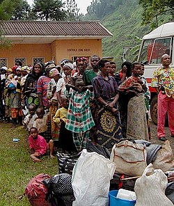
Inter-ethnic groups and raised suspicions against groups whose Congolese nationality was deemed questionable. The Burundian and Rwandan communities that were not invited to the Conference were also excluded from the census of nationals ahead of the elections. Faced with unemployment and discrimination, many young people from Rwandan communities left Uganda in 1990 to join the Rwandan Patriotic Front (RPF) movement. Their departure reinforced the perception that they were outsiders. The situation seriously deteriorated in 1994 following the Rwandan Genocide when the entry of the RPF into Rwanda led to an exodus of Interahamwe (genocidaires) and nearly two million Rwandan Hutu refugees to the DRC. [28] Some communities, accused of having collaborated with the Tutsi, were targeted by the Hutu. Conversely, the Congolese Hutu, assimilated to those responsible for the genocide, suffered reprisals from the Tutsi. In 1995, the Transitional Parliament then adopted a resolution demanding the expulsion of all Rwandan and Burundian refugees and immigrants.

Rape has been used as a weapon of war in both the First Congo War and Second Congo War. DRC Rwanda line.jpg
Rape has been used as a weapon of war in both the First Congo War and Second Congo War.

During the First Congo War, after Mobutu provided refuge for Hutu refugees and Interahamwe, the Rwanda and Uganda armies invaded Zaire in 1996. The Alliance of Democratic Forces for the Liberation of Congo (AFDL), led by Laurent Désiré Kabila and supported by the Rwandans and the Ugandans, brutally dismantled the refugee camps and ousted Mobutu from power. At that time, the Banyamulenge occupied positions of authority in the administrative province of South Kivu and the territory of Uvira, causing considerable discontent among other communities, including Bwegera, Luberizi, Luvungi, Katala, Rubenga, Lubarika, Kakumbukumbu, Mutarule, Kagunga, Kiliba, Ndunda, Biriba, Sange, Rwenena, Kahororo, Kamanyola, Lemera, Makobola, Kasika, Kilungutwe, Kilungutwe River, Katogota, and in other areas of South and North Kivu. [29] [30]

During the Second Congo War, the alliance with Rwanda and Uganda ended in 1998 when Laurent Désiré Kabila attempted to gain independence from his associates and excluded Tutsis from his government. As Rwanda and Uganda armies invaded the DRC for the second time, the Congolese Tutsi community (Banyamulenge, Barundi and Banyarwanda) allied with the rebellion of the Rassemblement Congolais pour la Democratie (RCD), which controlled eastern DRC with the aim of obtaining citizenship and the right to political representation. [28] Many armed groups, Maï Maï, which enjoyed broad support from the communities’ “natives” and the government of Kinshasa, organized themselves as the opponents of the RCD. The civilian population has been directly targeted by acts of violence, resulting in heightened feelings of hatred and insecurity. [28]

The transitional period (1998–2003)

Students in Uvira marching under the slogan of "United Against Corruption for Development, Peace and Security". Students in Democratic Republic of the Congo march against corruption in education and impunity.jpg
Students in Uvira marching under the slogan of “United Against Corruption for Development, Peace and Security”.

While the RCD was part of the transitional government following the Pretoria Peace Accord, its members failed to secure seats in the first elections in 2006. The RCD remained without representation in provincial and national politics. Consequently, those dissatisfied with the integration process formed the CNDP (National Congress for the Defense of the People) movement, later re-established as M23 (the March 23 Movement) to maintain influence in Kinshasa and protect their economic and security interests in the East. [31] In November 2013, the FARDC (Forces Armées de la République Démocratique du Congo), assisted by the Rapid Intervention Brigade of the United Nations Organization Stabilization Mission in the Democratic Republic of the Congo (MONUSCO), put an end to these rebellions. These movements, which were mainly supported by Tutsi communities, reinforced feelings of hatred against these communities. [31]

Current inter-community tensions

Inter-community tensions between the two main communities of the Ruzizi Plain, the Bafuliru and the Barundi (the Banyamulenge being often assimilated to the Barundi), are still very strong. The conflicts to access power (especially customary power) and land are the most significant conflicts. The land conflict, also related to inter-community tensions, is expressed mainly through the conflict between farmers and herders (due to the wandering of animals). The conflict is particularly acute between Barundi and Banyamulenge herders, in search of pasture for their cattle, and Bafuliru farmers whose fields are regularly devastated by cows. [32] [33] Despite the waves of violence in the area and growing mistrust among communities, dialogue, based on a non-violent approach, remains the most frequently used conflict resolution mechanism.

Geography

Climate

An aerial view showing hills encircling Kamanyola in the Ruzizi Plain. Kamanyola Hills.jpg
An aerial view showing hills encircling Kamanyola in the Ruzizi Plain.

The Ruzizi Plain is characterized by a type of Aw4 tropical climate according to the Köppen Vladimir climatic classification, a bimodal rainfall regime of 600 to 900 mm and 18 to 32 °C. The maximum temperatures varied from 30.4 to 32.2◦C while the minimum temperatures ranged from 15.2 to 19.4◦C, with high daily variations (14◦C). The long rainy season commences in October and ends in February, while the short rainy season starts in February and ends in June. The short rainy season is followed by a four-month dry season (June to September). [34] [35] [36]

Vegetation

The vegetation of the Ruzizi Plain is dominated by grassy savannahs, consisting of grassland of medium density. Savannas alternate with a shrub and a thorny steppe. The gallery forest emerges throughout the Ruzizi Plain. [37]

Hydrology

The Ruzizi Plain consists of clay-sandy soils: the soil type encircles the entire parts of Kiliba at Gatumba to Lake Tanganyika, and the sandy-clayey soils: cover the rest of the Plain. The overall soil density varies from 1.28 to 1.65 g/cm3. The region is related to the tectonic movements that shaped the terrestrial forms of East Africa. [38] Soils are of vertisols and arenosols types associated with solonchaks with silty to sandy related texture. Most of these are of alluvial origin. The alluvium was brought to the Ruzizi Plain through the Ruzizi River and streams from the high mountains of the Nile Congo Watershed and the Mitumba mountains. Besides, extreme rainfall are associated with soil erosion and declined soil fertility. Consequently, planning the rainfed agriculture has become complex as irrigation facilities and appropriate water conservation practices are lacking. This discourages farmers from investing in sustainable, productive, and economically promising practices, since farming outcomes are unpredictable. [39] [38]

Agriculture

Rice cultivation In the Ruzizi Plain Rice Cultivation In Ruzizi Plain of DR Congo.jpg
Rice cultivation In the Ruzizi Plain

Agriculture and livestock farming are the main economic activities of the population. Of the 80,000 ha that constitutes the Ruzizi Plain, 14,000 ha are occupied by approximately 45,000 farmers whose main activity is agriculture, and the remainder is covered with pastures (35,000 ha) and marshes (30,000 ha). Rice, maize, cassava, groundnuts, beans, soybeans, tomatoes and vegetables are the main crops in the area. [40] Poorly educated people commonly practice family farming. Monoculture is dominant, especially for cereals (maize, rice, sugarcane); while grain and legumes are mainly intercropped with tuber crops (cassava-groundnut, cassava-soybean) and cereals (maize, sorghum). [40] [41] [42]  

See also

Related Research Articles

<span class="mw-page-title-main">South Kivu</span> Province of the Democratic Republic of the Congo

South Kivu is one of 26 provinces of the Democratic Republic of the Congo (DRC). Its capital is Bukavu.

Banyamulenge, also referred to as Nyamurenge and Banyamurenge, is a community from the Democratic Republic of the Congo's South Kivu province. The Banyamulenge are culturally and socially distinct from the Tutsi of North Kivu, with most speaking Kinyamulenge, a mix of Kinyarwanda, Kirundi, Ha language, and Swahili. Banyamulenge are often discriminated against in the DRC due to their Tutsi phenotype, similar to that of people living in the Horn of Africa, their insubordination towards colonial rule, their role in Mobutu's war against and victory over the Simba Rebellion, which was supported by the majority of other tribes in South Kivu, their role during the First Congo War and subsequent regional conflicts (Rally for Congolese Democracy–Goma, Movement for the Liberation of the Congo, National Congress for the Defence of the People, and more importantly for the fact that two of the most influential presidents of their country declared them as enemy of the State both in 1996 and 1998.

<span class="mw-page-title-main">Uvira</span> City in Democratic Republic of the Congo

Uvira is the capital city of the Uvira Territory in the South Kivu Province of the Democratic Republic of the Congo (DRC). It is situated between Lake Tanganyika and the Mitumba Mountains and covers an area of approximately 16km.

The Banyarwanda (Kinyarwanda: Abanyarwanda, Umunyarwanda are a Bantu ethnolinguistic supraethnicity that comprises the dominant ethnic groups of Rwanda, namely the Hutu, Tutsi and Twa among others. The Banyarwanda are also minorities in neighboring Burundi, DR Congo, Uganda, Tanzania, and Kenya.

<span class="mw-page-title-main">Minembwe</span> Village in South Kivu, Democratic Republic of the Congo

Minembwe is a cluster of several villages located in the highlands of the Lulenge, within the Fizi Territory of South Kivu Province in the Democratic Republic of the Congo (DRC). It is situated at an altitude of about 2,500 meters above sea level, in a hilly and mountainous region covered with forests, which provides fertile land for agriculture. It is approximately 150 kilometers south of Bukavu, the capital city of South Kivu. The region is also home to various streams and rivers that flow into Lake Tanganyika, the second-deepest lake in the world.

<span class="mw-page-title-main">Mulenge</span> Village in Democratic Republic of the Congo

Mulenge is a village encircled by hills in the Bafuliiru Chiefdom, located in the Uvira Territory of South Kivu Province, Democratic Republic of the Congo (DRC). It is situated on the high plateaus of the Itombwe massif, overlooking the locality of Uvira. The area has conventionally been inhabited by various ethnic groups, including the remnants of the autochthonous population of African Pygmies, as well as Bantu ethnic groups such as the Mbuti, Fuliiru, and Nyindu. The region boasts high agricultural productivity, with two harvests typically achievable each year.

<span class="mw-page-title-main">Runingo</span> Grouping in South Kivu, Democratic Republic of the Congo

Runingo, commonly known as Runingu, is one of the groupements (groupings) that constitutes the Bafuliiru Chiefdom in the Uvira Territory of the South Kivu Province in the eastern part of the Democratic Republic of the Congo (DRC). It is situated near the border with Burundi, along National Highway 5, to the north of Butaho.

<span class="mw-page-title-main">Furiiru people</span> African ethnic group

The Fuliiru people are a Bantu ethnic group predominantly inhabiting the east-central highlands of the Democratic Republic of the Congo (DRC). They reside in the South Kivu Province, situated south of Lake Kivu and to the north and northwest of Uvira Territory, along the Ruzizi Plain near the border with Rwanda and Burundi, where a contingent of Fuliiru also resides. According to the 2009 census, their population estimate exceeded 250,000, while a 1999 estimate of Kifuliiru-language speakers placed the number at 300,000. The Fuliiru are renowned for their skilled craftsmanship, particularly in the production of pottery and basketry. Their handcrafted baskets are highly coveted for their intricate designs and exceptional quality, and are frequently employed for storage, decoration, and even as musical instruments.

<span class="mw-page-title-main">Uvira Territory</span> Territory in South Kivu, DR Congo

Uvira Territory is a territory in South Kivu, Democratic Republic of the Congo. It is bordered by Walungu Territory to the north, Mwenga Territory to the west, Fizi Territory to the south, and Burundi and Lake Tanganyika to the east. Its capital is Uvira.

<span class="mw-page-title-main">Luvungi</span> Town in Democratic Republic of the Congo

Luvungi, also known as Itara-Luvungi, is one of the groupements (groupings) within the Bafuliiru Chiefdom in the Uvira Territory of the South Kivu Province in the eastern Democratic Republic of the Congo (DRC). Situated on the Ruzizi Plain, it lies at the borders of Uvira Territory and Walungu Territory, in close proximity to the frontiers of Rwanda and Burundi. Luvungi is home to a population of approximately 85,000 individuals, predominantly consisting of Fuliru agriculturalists who play a vital role in the local community. There's also has a small population of Vira, Bembe, Lega, Shi, Burundians and Banyamulenge. Its economy is founded mainly on subsistence agriculture and the artisanal mining of cassiterite, an ore of tin.

Lemera is one of the groupements (groupings) within the Bafuliiru Chiefdom, located in the Uvira Territory of the South Kivu Province in the eastern part of the Democratic Republic of the Congo (DRC). It is situated in the northwestern part of the Uvira Territory, approximately 60 kilometers north of Bukavu and 90 kilometers southwest of the border with Rwanda and Burundi. Lemera is in close proximity to several villages, including Kasheke, Nyambasha, Luzira, Lukayo, Kajuju, Lushasha, and Ihusi.

<span class="mw-page-title-main">Sange, Democratic Republic of the Congo</span> Town in the Democratic Republic of the Congo

Sange is a village located in the Bafuliiru Chiefdom in the Uvira Territory of the South Kivu Province, Democratic Republic of the Congo. It is situated 24 km from the Burundian border, at 1,021 meters altitude.

<span class="mw-page-title-main">Katogota</span> Village in the DRC

Katogota is a village located in the Itara-Luvungi grouping within the Bafuliiru Chiefdom in Uvira Territory of the South Kivu Province in the Democratic Republic of the Congo (DRC). Situated approximately 60 km south of Bukavu, Katogota is in close proximity to the Kamonyi and Rusagara villages, near the border regions of Rwanda and Burundi.

<span class="mw-page-title-main">Kamanyola</span> Grouping in South Kivu, DR Congo

Kamanyola is one of the groupements (groupings) within the Ngweshe Chiefdom of the Walungu Territory. It is located in the Ruzizi Plain in the South Kivu Province of the Democratic Republic of the Congo (DRC), sharing a border with Rwanda and Burundi. Kamanyola stands at a height of 901 meters and is closely situated to the suburb of Mwaro and the village of Mubombo.

Bwegera is a village in the Bafuliiru Chiefdom in the Uvira Territory of South Kivu Province, Democratic Republic of the Congo. Bwegera has an elevation of 952 meters and is situated in the vicinity of the Kakamba and Nyaruhuhuma villages. The region It's crossed by Lake Tanganyika, providing a vital source of water and transportation for the local inhabitants. Bwegera is rich in building materials such as rubble, sand, and baked bricks, making it an ideal location for construction and development. The region also encompasses a vast rural area where agriculture, animal breeding, and fishing are the primary means of livelihood.

<span class="mw-page-title-main">Lubarika</span> Village in the DRC

Lubarika is a village situated in the hills and high plateaus of Bafuliiru Chiefdom in Uvira Territory, located in the South Kivu Province in the eastern part of the Democratic Republic of Congo (DRC). It sits at an elevation of 969 meters above sea level and is near the villages of Murunga and Nyakagobe II. Lubarika is a predominantly agricultural region with large hectares used for subsistence agriculture. Agriculture is practiced by an extensive segment of the population. The products grown are mainly intended for domestic consumption and commercialization. Moreover, fishing is carried out artisanally in Lake Tanganyika by the local population.

<span class="mw-page-title-main">Mutambala</span> Sector in the DRC

Mutambala is a sector that constitutes one of the four sectors in the Fizi Territory of the South Kivu Province in the eastern part of the Democratic Republic of the Congo. Mutambala is situated near Lake Tanganyika, in the west by the Lulenge sector, in the north by the Tangani'a sector, and in the south by the Ngandja sector. It has a surface area of 777 km 2. The sector consists of five groupings (groupements), including the Basimukindja groupings, the Batombwe groupings, and the Babwari groupings.

Bibogobogo, also known as Bibokoboko in Kibembe, is a village in the middle plateaus of the Mutambala Sector in the Fizi Territory in the South Kivu Province of the Democratic Republic of the Congo (DRC). It is situated in the forested mountains and middle plateaus, overlooking Baraka in the south-west, near Kisombe and Bibokoboko II villages. Bibogobogo shares the borders with Uvira Territory in the North, the Mwenga Territory and Shabunda Territory in the West, the Kalemie Territory in the South, and Lake Tanganyika in the East. The regional soil is composed of metals, including sodium, potassium, calcium, magnesium, iron, aluminium and mercury, making it suitable for gold plating, mercury pollution, pollution index and agriculture. Despite being rich in forest biodiversity, the region is in a state of poverty and insecurity which hampers any attempt at sustainable development. The ongoing ethnic conflict in the region continues to affect communities identified as Babembe, Bafuliiru, Babwari, Babuyu, Banyindu, Balega (Warega), Bamushi, and Banyamulenge.

Kiringye is a village situated in the Lemera groupement within the Bafuliiru Chiefdom, which is part of Uvira Territory in the South Kivu Province in the eastern region of the Democratic Republic of the Congo (DRC). The village is located at an elevation of 928 meters and is in close proximity to the localities of Luburule and Karenzu.

The Bafuliiru Chiefdom, formerly known as Chefferie des Bafulero, is a traditional administrative unit located in the Democratic Republic of the Congo (DRC). It is situated in the Uvira Territory, which is part of the South Kivu Province in eastern DRC.

References

  1. Newbury, Catharine (1975). The Cohesion of Oppression: A Century of Clientship in Kinyaga, Rwanda · Volume 1. Madison, Wisconsin: University of Wisconsin-Madison. p. 40.
  2. 1 2 Chubaka, Bishikwabo (1987). "Aux Origines de La Ville D'Uvira Selon Les Explorateurs et Les Pionniers de La Colonisation Belge Au Zaire (1840-1914)". Civilisations. 37 (1): 83–126. ISSN   0009-8140. JSTOR   41968746.
  3. Guillaume, H.A. (1950). Monographie de la plaine de la Ruzizi (in French).
  4. Monographie de la province du Sud-Kivu (in French). La République. 1998.
  5. "Reports of Mandatory Powers: Submitted to the Council of the League of Nations in Accordance with Article 22 of the Covenant and Considered by the Permanent Mandates Commission at Its Sixth-[eighth, Tenth] Session (June-July 1925)-[February-March 1926, November 1926] · Issue 30". The University of Michigan. 1925. p. 51. Retrieved 2023-04-21.
  6. Rushigira, Cadeau; Mirindi, Germaine Furaha; Ngezirabona, Stany Vwima (2021-05-23). "Socio-technical Context of Market Gardening in the Ruzizi Plain in Eastern DRC: Constraints and Stakeholders' Strategies". European Journal of Agriculture and Food Sciences. 3 (3): 69–75. doi: 10.24018/ejfood.2021.3.3.295 . ISSN   2684-1827. S2CID   236360144.
  7. Muvundja, Fabrice Amisi; Walumona, Jacques Riziki; Dusabe, Marie-Claire; Alunga, Georges Lufungula; Kankonda, Alidor Busanga; Albrecht, Christian; Eisenberg, Joachim; Wuest, Alfred, eds. (2022). "The Land-Water-Energy Nexus of Ruzizi River Dams (Lake Kivu Outflow, African Great Lakes Region): Status, Challenges, and Perspectives". Frontiers in Environmental Science. 10. doi: 10.3389/fenvs.2022.892591 . ISSN   2296-665X.
  8. "Strategic Action Plan for the integrated management of the Lake Kivu and Rusizi/Ruzizi River Basin and its Basin Authority ABAKIR" (PDF). ABAKIR. July 2022. Retrieved 2023-05-03.
  9. Vlassenroot, Koen (2013). "South Kivu: Identity, Territory, and Power in the Eastern Congo". Rift Valley Institute. London, England. Retrieved 2023-04-21.
  10. AfricaNews (2018-03-02). "RDC : insécurité dans la plaine de la Ruzizi". Africanews (in French). Retrieved 2023-04-21.
  11. "RDC : La plaine de la Ruzizi sous la menace d'une insécurité alimentaire". Afrique Sub-Saharienne. Retrieved 2023-04-21.
  12. "Reportage Afrique - RDC: la plaine de la Ruzizi est de nouveau menacée par les groupes armés [1/5]". RFI (in French). 2022-10-30. Retrieved 2023-04-21.
  13. 1 2 Moeller, Alfred (1936). "Les grandes lignes des migrations des Bantus de la province orientale du Congo belge" (PDF). congoforum.be/fr/ (in French). G. van Campenhout. Retrieved 2023-04-21.
  14. Africa-Tervuren, Volumes 26-29 (in French). Tervuren, Flemish Brabant, Belgium: Royal Museum for Central Africa. 1980. pp. 39–40.
  15. Mémoires in-8o: Verhandelingen, Volume 6 (in French and Afrikaans). La Classe. 1936. p. 136.
  16. Verhaegen, Benoît (1966). "Rebellions au Congo, Volume 1" (in French). The University of Michigan. p. 261. Retrieved 2023-04-21.
  17. Depelchin, Jacques (1974). From Pre-capitalism to Imperialism: A History of Social and Economic Formations in Eastern Zaire (Uvira Zone, C. 1800-1965). Stanford, California: Stanford University. pp. 80–90.
  18. Newbury, David S. (1979). Kings and Clans on Ijwi Island (Zaire), C. 1780-1840, Volume 2. Madison, Wisconsin: University of Wisconsin--Madison.
  19. Muchukiwa, Bosco (2006). Territoires ethniques et territoires étatiques: pouvoirs locaux et conflits interethniques au Sud-Kivu (R.D. Congo). Harmattan. pp. 90–96. ISBN   9782747598576 . Retrieved 2023-04-21.
  20. Spitaels, R (1953). Transplantation de Banyarwanda dans le Nord Kivu, Problèmes d'Afrique Centrale 2 (in French). p. 110.
  21. Demographic Dynamics and Population Mobility in East Africa (in English and French). IFRA. 1996. p. 39.
  22. Nziem, Isidore Ndaywel è; Mudimbe-Boyi, Elisabeth, eds. (2009-05-01). Images, mémoires et savoirs - Une histoire en partage avec Bogumil Koss Jewsiewicki (in French). Paris, France: Éditions Karthala. p. 473. ISBN   978-2-8111-3140-1.
  23. La nouvelle histoire du Congo: Mélanges eurafricains offerts à Frans Bontinck, C.I.C.M. - Cahiers 65-66-67 (in French). Paris, France: Editions L'Harmattan. October 2004. p. 53. ISBN   9782296359468.
  24. Kapapi, John (March 28, 2019). Lies of the Tutsi in Eastern Congo/Zaire: A Case Study: South Kivu (Pre-Colonial to 2018). Bloomington, Indiana. ISBN   9781796022896.{{cite book}}: CS1 maint: location missing publisher (link)
  25. United Nations. Security Council (1996). Official Records: Proces-verbaux Officiels (in English and French). Minnesota, United States: University of Minnesota. p. 86.
  26. Klusmeyer, Douglas, ed. (November 2010). Citizenship Today: Global Perspectives and Practices. ed. T. Alexander Aleinikoff. Massachusetts Avenue NW, Washington, DC: Brookings Institution Press. p. 198. ISBN   9780870033384.
  27. 1 2 "Comprendre les conflits dans l'Est du Congo: la plaine de la Ruzizi" (PDF). International Crisis Group. July 23, 2013. pp. 5–6. Retrieved 2023-04-21.
  28. 1 2 3 Kiley, Penny (2012-09-10). "Sortir de l'impasse : Vers une nouvelle vision de la paix à l'est de la RDC". International Alert (in French). pp. 20–24. Retrieved 2023-04-21.
  29. Jason Kauahooululaunaheleonakuahiwi Stearns, Jason Stearns (2013). "Les Banyamulenge, insurrection et exclusion dans les montagnes du Sud-Kivu". Rift Valley Institute. pp. 22–25. Retrieved 2023-04-21.
  30. "Report of the Mapping Exercise documenting the most serious violations of human rights and international humanitarian law committed within the territory of the Democratic Republic of the Congo between March 1993 and June 2003" (PDF). August 2010. pp. 91–95. Retrieved 2023-04-21.
  31. 1 2 "From CNDP to M23 | Rift Valley Institute". riftvalley.net. Retrieved 2023-04-22.
  32. Stearns, Jason (2013). "Resistance and racketeering in Fizi, South Kivu" (PDF). Rift Valley Institute | Usalama Project. Retrieved 2023-04-22.
  33. Vlassenroot, Koen, ed. (2004). Conflict and social transformation in eastern DR Congo. ed. Timothy Raeymaekers. Academia Press Scientific Publishers. p. 41. ISBN   9789038206356.
  34. Iragi, Daniel Muhindo; Mwanjalolo, Jackson Gilbert Majaliwa; Katushabe, Alice Amonding; Masamba, Jean Walangululu; Nkuba, Bossissi; Iragi, Daniel Muhindo; Mwanjalolo, Jackson Gilbert Majaliwa; Katushabe, Alice Amonding; Masamba, Jean Walangululu; Nkuba, Bossissi (2017). Iragi, Daniel Muhindo; Mwanjalolo, Jackson Gilbert Majaliwa; Katushabe, Alice Amonding; Masamba, Jean Walangululu; Nkuba, Bossissi (eds.). "Projected impact of climate change on rice yield in two agro-ecological zones in South- Kivu, Democratic Republic of Congo". African Journal of Rural Development: 299–310. doi:10.22004/ag.econ.263431. ISSN   2415-2838.
  35. Bagula, Espoir M.; Majaliwa, Jackson Gilbert M.; Mushagalusa, Gustave N.; Basamba, Twaha A.; Tumuhairwe, John-Baptist; Mondo, Jean-Gomez M.; Musinguzi, Patrick; Mwimangire, Cephas B.; Chuma, Géant B.; Egeru, Anthony; Tenywa, Moses M. (September 2022). "Climate Change Effect on Water Use Efficiency under Selected Soil and Water Conservation Practices in the Ruzizi Catchment, Eastern D.R. Congo". Land. 11 (9): 1409. doi: 10.3390/land11091409 . ISSN   2073-445X.
  36. Manirakiza, Diomède; Namubamba, Adolphe Mukenge; Bagula, Espoir Mukengere (2022-04-13). "Analysis of Rice Farmers' Adaptation to Climate Change in the Ruzizi Plain (Drc)". Rochester, NY. doi:10.2139/ssrn.4083388. S2CID   248192234. SSRN   4083388.{{cite journal}}: Cite journal requires |journal= (help)
  37. Byavu, Njangwe; Henrard, C.; Dubois, M.; Malaisse, F. (2000). "Phytothérapie traditionnelle des bovins dans les élevages de la plaine de la Ruzizi". Biotechnologie, Agronomie, Société et Environnement. S2CID   85066737.
  38. 1 2 Ilunga, L. (2007). "Environnements sédimentaires et minéralogie des formations superficielles de la Plaine de la Ruzizi (Nord du lac Tanganyika) · GéoProdig, portail d'information géographique". geoprodig.cnrs.fr. pp. 71–104. Retrieved 2023-04-22.
  39. Dessart, François J.; Barreiro-Hurlé, Jesús; van Bavel, René (2019). "Behavioural factors affecting the adoption of sustainable farming practices: a policy-oriented review". academic.oup.com. pp. 417–471. Retrieved 2023-04-22.
  40. 1 2 Walangululu, Jean M.; Yohali, Diane; Nankafu, Rosette; Bisimwa, Mugaruka (2021). "Performance of introduced irrigated rice varieties in Ruzizi plain, South Kivu province, DR Congo" (PDF). Ruforum. Retrieved 2023-04-22.
  41. https://eurekamag.com/research/000/618/000618781.php
  42. https://eurekamag.com/research/064/183/064183497.php