
Mount Tambora, or Tomboro, is an active stratovolcano in West Nusa Tenggara, Indonesia. Located on Sumbawa in the Lesser Sunda Islands, it was formed by the active subduction zones beneath it. Before 1815, its elevation reached more than 4,300 metres high, making it one of the tallest peaks in the Indonesian archipelago.

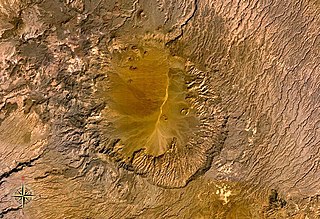
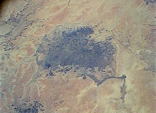
Emi Koussi is a high pyroclastic shield volcano that lies at the southeast end of the Tibesti Mountains in the central Sahara, in the northern Borkou Region of northern Chad. The highest mountain of the Sahara, the volcano is one of several in the Tibesti range, and reaches an elevation of 3,415 metres (11,204 ft), rising 3 km (1.9 mi) above the surrounding sandstone plains. The volcano is 60–70 kilometres (37–43 mi) wide and has a volume of 2,500 cubic kilometres (600 cu mi).
The Tibesti Mountains are a mountain range in the central Sahara, primarily located in the extreme north of Chad, with a small portion located in southern Libya. The highest peak in the range, Emi Koussi, lies to the south at a height of 3,415 meters (11,204 ft) and is the highest point in both Chad and the Sahara. Bikku Bitti, the highest peak in Libya, is located in the north of the range. The central third of the Tibesti is of volcanic origin and consists of five volcanoes topped by large depressions: Emi Koussi, Tarso Toon, Tarso Voon, Tarso Yega and Toussidé. Major lava flows have formed vast plateaus that overlie Paleozoic sandstone. The volcanic activity was the result of a continental hotspot that arose during the Oligocene and continued in some places until the Holocene, creating fumaroles, hot springs, mud pools and deposits of natron and sulfur. Erosion has shaped volcanic spires and carved an extensive network of canyons through which run rivers subject to highly irregular flows that are rapidly lost to the desert sands.

Parinacota, Parina Quta or Parinaquta is a dormant stratovolcano on the border of Chile and Bolivia. Together with Pomerape it forms the Nevados de Payachata volcanic chain. Part of the Central Volcanic Zone of the Andes, its summit reaches an elevation of 6,380 metres (20,930 ft) above sea level. The symmetrical cone is capped by a summit crater with widths of 1 kilometre (0.62 mi) or 500 metres (1,600 ft). Farther down on the southern slopes lie three parasitic centres known as the Ajata cones. These cones have generated lava flows. The volcano overlies a platform formed by lava domes and andesitic lava flows.

Toussidé is a potentially active stratovolcano in Chad. Toussidé lies in the Tibesti Mountains, the large Yirrigué caldera and the smaller Trou au Natron and Doon Kidimi craters are close to it. It has an elevation of 3,265 m (10,712 ft) above sea level. The volcano is the source of a number of lava flows, which have flowed westward away from Toussidé and east into the Yirrigué caldera.
The Tarso Voon is a 3,100-metre (10,200 ft) high stratovolcano in the north of the Republic of Chad. It is located in the western center of the Tibesti Mountains.

Tarso Toh is a volcanic field located in Chad, north of Tarso Toussidé volcano. It fills valleys and plains over an area of 80 km in east-west direction and 20–30 km in north-south direction. It contains 150 scoria cones and two maars.
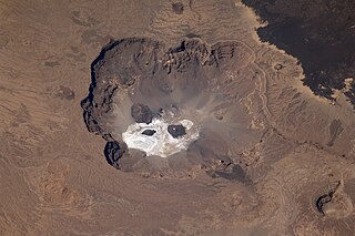
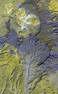
Trou au Natron or Doon Orei is a volcanic caldera of the Tibesti Massif in the nation of Chad in Northern Africa. The volcano is extinct. It is unknown when it last erupted. Its volcano number is 0205–01. Trou au Natron is located just south-east of Toussidé, the westernmost volcano of the Tibesti Mountains. Its edge cuts into the nearby Yirrigue caldera.

Anyuyskiy is an extinct volcano in the Anyuy Mountains, Chukotka Autonomous Okrug, Far Eastern Russia. It is formed by two systems: one is formed by long lava flows which disrupted the valley of the Monni River. Later, a volcanic cone formed, experiencing explosive activity and eventually extruding a long lava flow.
The Dacht-i-Navar Group is a volcanic field in Afghanistan. It consists of a group of lava domes and stratovolcanoes at the southern end of the Dacht-i-Navar depression and partly extend north of the same depression. They were active during the Pliocene and Pleistocene.
Lake Ptolemy is a former lake in Sudan. This lake formed during the Holocene in the Darfur region, during a time when the monsoon over Africa was stronger. The existence of the lake is dated between about 9,100–2,400 years before present. This lake could have reached a surface area of 30,750 square kilometres (11,870 sq mi), larger than present-day Lake Erie, although estimates of its size vary and it might have been much smaller. The shorelines in some places, insofar as they are recognizable, feature riparian landscapes and reeds. The lake was a freshwater lake replenished by groundwater and runoff from neighbouring mountains and might itself have been the source for the Nubian Sandstone Aquifer System. The lake featured a diverse ecosystem with a number of species, and possibly facilitated the spread of species between the Nile and Lake Chad.

Waw an Namus is a volcano in Libya. Of either Pleistocene or Holocene age, it is located within the eastern Fezzan region. The origin of the volcanism there and at Al Haruj farther north is not clear. Radiometric dating has yielded an age of about 200,000 years, but other circumstantial evidence points to a formation of the volcano during Holocene or even historical times.

Tarso Toon is a volcano in the central Tibesti mountains.
Tarso Yega is a stratovolcano in Tibesti, with a summit caldera that is 19 by 20 kilometres wide and 300 metres (980 ft) deep. The summit of the volcano reaches a height of 2,972 metres (9,751 ft), and its caldera is the largest caldera of the Tibesti. Neighbouring volcanoes include Doudriki east, Ehi Dosoatou south and Ehi Fodoboro southwest of the caldera. The Enneri Yega river drains the caldera westward and then south, before joining the Enneri Debarsar; in the past (Holocene) the rivers reached Lake Chad and lakes formed in Tarso Yega.
Meidob volcanic field is a Holocene volcanic field in Darfur, Sudan. It is one of several volcanic fields in Africa whose origin is explained by the activity of mantle plumes and their interaction with crustal structures. Meidob lies at the southern margin of the Sahara.

Deriba is a Pleistocene or Holocene caldera in Darfur, Sudan. Part of the volcanoes of the Marra Mountains, it lies on the Darfur dome and like the Tagabo Hills and Meidob Hills volcanism may be the product of a mantle plume. After the separation of South Sudan, the highest point of Sudan is on the margin of the caldera.

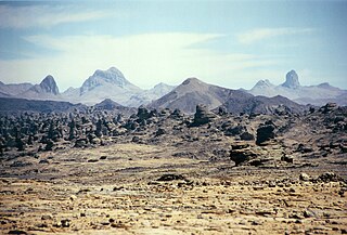
Atakor volcanic field is a volcanic field in Algeria. It lies in the Hoggar mountains and consists of a variety of volcanic features such as lava flows and about 450 individual vents which create a spectacular scenery.
Tarso Ahon is a Pleistocene volcano in Tibesti, north of Emi Koussi from which it is separated by deep gorges. It covers a surface of about 50 by 60 kilometres and is a so-called volcanic plateau with three summits: Arken Ahon, Dondomé, Tarso Ahon and Tarso Mohi. However, contrary to its plateau-like appearance the basaltic surfaces of Tarso Ahon are difficult to access and steep. Tarso Ahon has erupted andesite, rhyolite and similar magmas, and more recently basalts which form lava flows.

Bayuda volcanic field is a volcanic field in Sudan, within the Bayuda Desert. It covers a surface of about 11 by 48 kilometres and consists of a number of cinder cones as well as some maars and explosion craters. These vents have erupted aa lava flows.
Soborom is a group of hot springs with accompanying fumaroles and mud volcanoes in the Tibesti Mountains of Chad. Three dispersed groups of vents are active there, some of which are used as spas by the local population.
