Tel Hadid

Last updated

Tel Hadid is an archaeological site in Israel. It is located on an isolated hill, 147 metres (482 ft) above sea level, south of a tributary of Ayalon River. The site overlooks the central coastal plain of Israel, the Lydda Valley, and the Tel Aviv metropolitan area, offering a strategic vantage point.

Contents

Tel Hadid has a rich historical significance, with its earliest mentions found in the books of Ezra and Nehemiah among the towns resettled by those returning from the Babylonian exile. It was also fortified by Simon Thassi during the Maccabean war with Diodotus Tryphon, as described in 1 Maccabees. Throughout history, its strategic importance was recognized by various rulers, including Vespasian during the Jewish Revolt. The site has been subject to numerous archaeological excavations, revealing extensive remains dating from the Intermediate Bronze Age to the Modern Era.

Location and landscape

Byzantine-period wine press and olive orchard on the lower terrace of Tel Hadid Hadid 117.jpg
Byzantine-period wine press and olive orchard on the lower terrace of Tel Hadid

Tel Hadid is located on an isolated hill, 147 metres (482 ft) above sea level south of a tributary of Naḥal Ayalon. It overlooks the central coastal plain of Israel, the Lydda Valley and the Tel Aviv metropolitan area.

The local rock in this area is chalk covered by Nari (hard limestone) crust. Accelerated processes of chalk decay created many natural caves and fallen debris, commonly found in various locations at the site. Most of Tel Hadid is currently covered by olive plantations, which had been cultivated by the inhabitants of village al-Haditha, and by pine trees, which were planted by the Jewish National Fund. Remains of houses and the cemetery of al-Haditha are still noticeable on the ground.

Identification and early history of Hadid

Madaba Map (detail), showing Jerusalem and, in the bottom left, the village of Adiatha Madaba map.jpg
Madaba Map (detail), showing Jerusalem and, in the bottom left, the village of Adiatha

During early scholarship, led by Church Fathers such as Eusebius, Haditha (Greek: Άδιθά or Aδιθα) was identified as the site of Adithaim, a town in the allotment of the Tribe of Judah (Joshua 15:36). [1] Similarly, the famous Madaba Map, features a village northwest of Jerusalem with the caption Adiathim that is now Aditha. But Adithaim is to be sought in the Judean Shephelah, and it seems that the similarity in the sounds of the toponym was behind this confusion. [2] A different identification of Haditha suggested centuries later since was subsequently followed in scholarship. A 13th century Jewish scholar named Isaac HaKohen Ben Moses, better known by his pen name, Ishtori Haparchi, traveled seven years across the Holy Land and documented his insights on the local topography and toponomy in his book Kaftor Vaferach (Hebrew: כפתור ופרח; literally “Button and Flower”). There he wrote that the village of Haditha (Hebrew חדתא), located on top of a round hill two hours walk east of Lydda, is the place of Biblical Hadid. [3]

Hadid is first mentioned in the books of Ezra and Nehemiah among the towns settled by those returning from the Babylonian exile. [4] According to the 1 Maccabees, Hadid (Greek: Αδιδα) was fortified by Simon Thassi during the war with Diodotus Tryphon. [5] The battle between those armies took place in the valley it overlooks. [6] The strategic importance of Hadid was maintained for generations. According to Josephus, Vespasian, who led the legions against the Jewish Revolt, decided to block the ways leading to Jerusalem and chose to fortify Hadid (Άδδιδά). [7] Lastly, a rabbinical tradition claims that Hadid was among the towns fortified during the days of Joshua. [8]

In 1944 the village of al-Haditha had 760 inhabitants. It was captured by Israeli forces on July 12, 1948, during Operation Danny, following the conquest of Lydda and Ramle, and subsequently depopulated of its residents. [9] [10]

Archaeological explorations at the site

Exploration of the site has primarily included salvage excavations. In 1940 J. Ory excavated a Byzantine-period mosaic floor, depicting a Nilotic scene. [11] A major salvage excavation project took place in 1995–1997, during which extensive remains were unearthed across a lower terrace to the north of the high mound. [12] [13] According to preliminary publications, the earliest remains date to the Intermediate Bronze Age. After a settlement gap of centuries, the site was resettled during the Late Bronze Age. The settlement reached its peak in the Iron Age II, under the Kingdom of Israel and, after its downfall, under the Assyrian Empire. Additional remains were dated to the Persian Period until the Modern Era.

Within the remains of an Iron Age II settlement, two cuneiform tablets were found, and were dated to the first half of the 7th century BCE. [14] These two legal documents refer to individuals who bear non-local (mainly Akkadian) names, and were interpreted as members of deportee communities, brought to the country by the Neo-Assyrian Empire. [15] A similar scenario emerges from two tablets found over a century ago at Tel Gezer, where Aramean and Akkadian names are mentioned alongside a local name – Netanyahu. [16]

A new research project was launched in 2018, under the auspice of Tel Aviv University and the New Orleans Baptist Theological Seminary.

Related Research Articles

<span class="mw-page-title-main">Tel Lachish</span> Biblical city and an archeological site in Israel

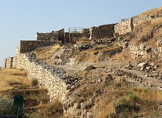
Lachish was an ancient Canaanite and Israelite city in the Shephelah region of Israel, on the south bank of the Lakhish River, mentioned several times in the Hebrew Bible. The current tell (ruin) by that name, known as Tel Lachish or Tell ed-Duweir, has been identified with the biblical Lachish. Today, it is an Israeli national park operated and maintained by the Israel Nature and Parks Authority. It lies near the present-day Moshav of Lakhish.

<span class="mw-page-title-main">Ramla</span> City in Israel

Ramla or Ramle is a city in the Central District of Israel. Ramle is one of Israel's mixed cities, with significant numbers of both Jews and Arabs.

<span class="mw-page-title-main">Ness Ziona</span> City in Central District, Israel

Ness Ziona is a city in Central District, Israel. In 2022 it had a population of 50,341, and its jurisdiction was 15,579 dunams (15.579 km2 [6.015 sq mi]).

<span class="mw-page-title-main">Ono, Benjamin</span> Biblical town in Benjamin

Ono was a biblical town of Benjamin in the "plain of Ono". The modern Kiryat Ono is not to be confused with the biblical Ono.

<span class="mw-page-title-main">Israel Finkelstein</span> Israeli archaeologist

Israel Finkelstein is an Israeli archaeologist, professor emeritus at Tel Aviv University and the head of the School of Archaeology and Maritime Cultures at the University of Haifa. Finkelstein is active in the archaeology of the Levant and is an applicant of archaeological data in reconstructing biblical history. Finkelstein is the current excavator of Megiddo, a key site for the study of the Bronze and Iron Ages in the Levant.

<span class="mw-page-title-main">Gezer</span> Archaeological site in the foothills of the Judaean Mountains

Gezer, or Tel Gezer, in Arabic: تل الجزر – Tell Jezar or Tell el-Jezari is an archaeological site in the foothills of the Judaean Mountains at the border of the Shfela region roughly midway between Jerusalem and Tel Aviv. It is now an Israeli national park. In the Hebrew Bible, Gezer is associated with Joshua and Solomon.

<span class="mw-page-title-main">Jonathan Apphus</span> Leader of the Hasmonean dynasty from 161 to 143 BCE

Jonathan Apphus was one of the sons of Mattathias and the leader of the Hasmonean dynasty of Judea from 161 to 143 BCE.

<span class="mw-page-title-main">Kedesh</span> Archeological site in Israel

Kedesh was an ancient Canaanite and later Israelite settlement in Upper Galilee, mentioned few times in the Hebrew Bible. Its remains are located in Tel Kedesh, 3 km northeast of the modern Kibbutz Malkiya in Israel on the Israeli-Lebanese border.

<i>Ophel</i> Biblical Hebrew term for urban elevation

Ophel is the biblical term given to a certain part of a settlement or city that is elevated from its surroundings, and probably means fortified hill or risen area. In the Hebrew Bible, the term is used about two cities: Jerusalem, as in 2 Chronicles 27:3 and 33:14 and Nehemiah 3:26 and 11:21, and Samaria, mentioned in 2 Kings 5:24. The Mesha Stele, written in Moabite, a Canaanite language closely related to Biblical Hebrew, is the only extra-biblical source using the word, also in connection to a fortified place.

<span class="mw-page-title-main">Hadid</span> Moshav in central Israel

Hadid is a moshav in central Israel. Located near Modi'in, it falls under the jurisdiction of Hevel Modi'in Regional Council. In 2022 it had a population of 931.

<span class="mw-page-title-main">Al-Haditha, Ramle</span> Place in Ramle, Mandatory Palestine

Al-Haditha was a Palestinian village in the Ramle Subdistrict. It was located 8 km northeast of Ramla, on the bank of Wadi al-Natuf. The site, now known as Tel Hadid, has yielded significant archaeological remains from many periods. Al-Haditha was depopulated during the 1948 Arab-Israeli War on July 12, 1948, under the first stage of Operation Dani.

<span class="mw-page-title-main">Yavne-Yam</span>

Yavne-Yam or Minet Rubin is an archaeological site located on Israel's Southern Coastal Plain, about 15 km south of Tel Aviv. Built on eolianite hills next to a small promontory forming the sole anchorage able to provide shelter to seagoing vessels between Jaffa and the Sinai, Yavne-Yam is notable for its role as the port of ancient Yavne. Excavations carried out by Tel Aviv University since 1992 have revealed continuous habitation from the second millennium BCE up to the Middle Ages; the famous Yavne-Yam ostracon is named after the site.

<span class="mw-page-title-main">Shimron</span>

Tel Shimron is an archaeological site and nature reserve in the Jezreel Valley.

<span class="mw-page-title-main">Jaffa</span> Ancient port and city in Tel Aviv, Israel

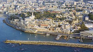
Jaffa, also called Japho or Joppa in English, is an ancient Levantine port city now part of Tel Aviv-Yafo, Israel, located in its southern part. The city sits atop a naturally elevated outcrop on the Mediterranean coastline.

<span class="mw-page-title-main">Rosh HaAyin South railway station</span> Railway station near Rosh HaAyin, Israel

Rosh HaAyin South railway station is a railway station near Rosh HaAyin, Israel. Despite the name, it is located north-west of the city, near the historic site of Antipatris.

<span class="mw-page-title-main">Tel Zeton</span> Archaeological site in Israel

Tel Zeton (Hebrew: תל זיתון, also known as Tell Abu Zeitun, is an archaeological site in the Pardes Katz neighborhood of Bnei Brak, Israel. It lies 800 m south of the Yarkon River. The mound rises to a height of 9 m above its surroundings and spans an area of 2–3 dunams. The site was inhabited in the Middle Bronze Age and later in the Iron and Persian periods. Jacob Kaplan identified the fortified settlement from the Persian period as a Jewish settlement from the time of the Return to Zion in the 5th century BCE, thanks to an ostracon bearing a Hebrew name which appears in the Hebrew Bible from the time of Nehemiah, a Jewish governor appointed by the Achaemenid Empire to govern the autonomous Jewish province. The site was inhabited as late as the 10th century CE, during the Roman, Byzantine, Early Arab, and Mamluk periods.

<span class="mw-page-title-main">Nadav Na'aman</span> Israeli archaeologist and historian

Nadav Na'aman is an Israeli archaeologist and historian. He specializes in the study of Near East in the second and first millenniums BC. His research combines the history of the Ancient Near East, archaeology, Assyrology, and the study of the Bible. He possesses broad knowledge in all these four branches of research.

<span class="mw-page-title-main">Modi'in (ancient city)</span> Ancient Jewish city near modern Modiin-Maccabim-Reut, Israel

Modi’in, also Modi’im, and later, Moditha, was an ancient Jewish city located in Judea, near the modern city of Modi'in, Israel. First mentioned in the Books of Maccabees, it was the hometown of the priestly Hasmonean family, who assumed leadership over Judea following the victorious Maccabean uprising.

<span class="mw-page-title-main">Horvat 'Eqed</span> Ruins of a fortified settlement in ancient Judea

Khirbet el-ʻAqd or Horvat ʻEqed is an archaeological site in the Latrun salient of the West Bank, approximately 22 km northwest of Jerusalem. The site, situated on a hill, contains the ruins of an ancient fortified town dating from the Hellenistic period through the Bar Kokhba revolt, after which the site was ultimately abandoned.

References

  1. Notley, R. Steven; Safrai, Ze'ev (2005). Eusebius, Onomasticon. A Triglott Edition with Notes and Commentary. Leiden: Brill. ISBN   9780391042179.
  2. Pioske, Daniel (18 May 2019). "Adithaim". Encyclopedia of the Bible Online.
  3. Hafarchi, Ishtori (18 May 2019). "Kaftor Vaferach". hebrewbooks. p. 300.
  4. Ezra 2:33; Nehemiah 7:37; see 11:34
  5. 1 Maccabees 12:38
  6. 1 Maccabees 13:13
  7. Wars 4, 9:1
  8. Mishna, Arakhin 9:6
  9. Abukhater, A. (2019). Palestine - Peace by Piece: Transformative Conflict Resolution for Land and Trans-boundary Water Resources. Springer International Publishing. ISBN   978-3-030-03985-1 . Retrieved 2020-02-27.
  10. Morris, Benny (2004). The Birth of the Palestinian Refugee Problem Revisited. Cambridge Middle East Studies. Cambridge University Press. p. xix. ISBN   978-0-521-00967-6 . Retrieved 2020-02-27.
  11. Avi-Yonah, Michael (1972). "The Haditha Mosaic Pavement". Israel Exploration Journal. 22: 118–122.
  12. Brand, Esther (1998). Salvage Excavations Near Tel Hadid: A Preliminary Report (in Hebrew). Tel Aviv University.
  13. Beit-Arieh, Itzhak (2008). "Hadid, Tel". New Encyclopaedia of Archaeological Excavations in the Holy Land. 5: 1757–1758.
  14. Na'aman, Nadav; Zadok, Ran (2000). "Assyrian Deportations to the Province of Samerina in the Light of Two Cuneiform Tablets from Tel Hadid". Tel Aviv. 27 (2): 159–188. doi:10.1179/tav.2000.2000.2.159. S2CID   162225582.
  15. Ibid., pp. 177–179
  16. Horowitz, Wayne; Oshima, Takayoshi; Sanders, Seth L. (2006). Cuneiform in Canaan: Cuneiform Sources from the Land of Israel in Ancient Times. Jerusalem: Israel Exploration Society. pp. 55–59.

31°57′49″N34°57′06″E / 31.96361°N 34.95167°E / 31.96361; 34.95167