The U.S. government constructed a number of temporary buildings on the National Mall during World War I and II which stood from 1918 until 1971. They were built due to the urgent need for office space during wartime, but they remained in use during peacetime even though they disrupted the intended layout of the mall according to the McMillan Plan for over half a century.
The entry of the United States into World War I in April 1917 led to an expansion of the federal government, causing urgent need for new office space to be constructed. Park space on the National Mall was appropriated for this purpose. Although the buildings were intended to be temporary, in 1918 the U.S. Commission of Fine Arts suggested that they would likely remain in use long past the end of the war.[2]
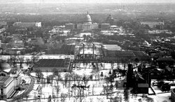
East of the Washington Monument
An eastward view of the National Mall from the top of the Washington Monument in 1922. The four structures and two smokestacks crossing the Mall are Temporary Buildings C–F and their associated heating plant. In the late 1930s, all but Building E were demolished.In 1942, Building E was joined by three new temporary buildings. They were demolished during 1966–1971. The National Air and Space Museum was constructed in their place.
World War I buildings
In 1918, the government built a complex of temporary buildings in the vicinity of 7th Street consisting of six lettered office buildings with an administration building, mechanical building, and restaurant at their center. They were designed by architect Horace Peaslee. The wards of the Armory Square Hospital had previously occupied the area during the Civil War. The Armory building remained in use to the immediate south of the temporary buildings. Although they did not conform to the McMillan Plan, their footprints left space for the streets planned to cross the Mall. Many of the buildings were of wood construction, although Building E was concrete.[1]:52–53 Unlike the other buildings, Building E was fireproof.[3]
Buildings A and B were demolished in the early 1920s.[4][5] Their site was assigned to the George Washington Memorial Building, whose foundation was constructed beginning in 1921, but the building was never completed. The site was later used for the National Gallery of Art.[1]:53,72
Beginning in 1929, and accelerating with the inauguration of Franklin D. Roosevelt in 1933, impetus increased for further implementation of the McMillan Plan. In 1930, the Commission of Fine Arts blamed the temporary buildings for "producing a depressing air of slovenliness" on the Mall.[1]:57 The central heating plant was seen as a priority to be demolished, as it sat exactly on the Mall's central axis. Demolition contracts were issued in May 1935.[1]:57,63,65 In 1934, the D Building was demolished, and the C Building in 1935.[1]:68–69[7] The F Building was demolished by 1937, leaving only the E Building standing.[8]
World War II buildings
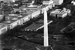
A 1946 map of central Washington, D.C., including the names and locations of temporary buildingsWorld War II Temporary Buildings T and U in 1950. These were demolished in 1958 for the construction of the National Museum of American History.
During World War II, the E Building remained from World War I. The other letters were reused for different buildings in different locations, some of which were not on the Mall. During World War II, the temporary buildings clustered near 7th Street on the south edge of the Mall were Buildings D, E, R, and S. Buildings T and U were built near 14th Street on the north side of the Mall.[9]
In 1958, Buildings T and U were demolished to make way for the construction of the National Museum of American History.[11] In 1966, the buildings near 7th Street were demolished.[12] In 1971, building E was the last temporary building on the Mall to be demolished. Part of the National Air and Space Museum occupied its spot.[13][14]
The Main Navy and Munitions Buildings were demolished in 1970. Much of their former site became Constitution Gardens, which was dedicated in 1976.[16][18]
Later buildings
In 1942, the Main Navy and Munitions Buildings were joined by a larger set of temporary buildings.[13][19] Temporary Buildings 3, 4, and 5 to the pool's east housed the Navy's Bureau of Ships. Buildings I, J, K, and L to its south housed the Bureau of Supplies and Accounts. Buildings N and W were constructed to its north, adjoining the Main Navy and Munitions Buildings.[9][20] These buildings were all demolished in 1964.[13][19]
ln 1972, Tempo A, B and C were located outside the walls of Ft. McNair. Tempo-A was mostly empty and used for furniture storage, with part of Nixon's reelection campaign occupying it for a short period of time. Tempo-B housed the just formed U.S. Army Criminal Investigation Command. Tempo-C housed the U.S. Park Police. [21]
This page is based on this Wikipedia article Text is available under the CC BY-SA 4.0 license; additional terms may apply. Images, videos and audio are available under their respective licenses.