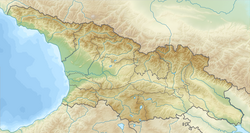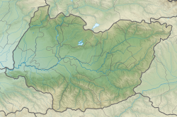
Imereti is a region of Georgia situated in the western part of the republic along the middle and upper reaches of the Rioni River. Imereti is the most populous region in Georgia. It consists of 11 municipalities and the city of Kutaisi, which is the capital of the region.

Samtredia is a town in Imereti, Georgia, lying in a lowland between the rivers Rioni and Tskhenis-Tsqali, 244 km (152 mi) west of the capital Tbilisi, and 27 km (17 mi) west of Georgia's second largest city Kutaisi. Georgia’s most important roads and railways converge there, making Samtredia the country’s vital transport hub. The Kopitnari Airport is also located in 10 km (6 mi) from Samtredia. The town's population is 25,318 as of the 2014 all-Georgia census. The climate is humid subtropical, with mild and warm winters and hot summers.
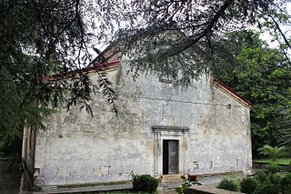
Khoni is a town in the Western Georgian region (mkhare) of Imereti with the population of 8987. It is situated on the left bank of the Tskhenistkali River in the north-west of Imereti, close to the border with the region of Samegrelo-Zemo Svaneti and 266 km west of Georgia's capital Tbilisi. The town serves as an administrative centre of the Khoni District. Its economy is based on agriculture, particularly tea production.

Oni is a town in Racha-Lechkhumi and Kvemo Svaneti region (mkhare), Georgia. Historically and ethnographically, it is part of Racha, a historic highland province in western Georgia. The town also serves as an administrative center of the Oni district (raioni).

Baghdati is a town of 3,700 people in the Imereti region of western Georgia, at the edge of the Ajameti forest on the river Khanistsqali, a tributary of the Rioni.

Zestafoni or Zestaponi is the administrative center of Zestafoni District in Western Georgia. Zestafoni is the center of an ancient, historical part of Georgia – Margveti, which is a part of Imereti province. Zestafoni is the center of Margveti's Eparchy of the Georgian Orthodox Church. Zestafoni is situated in the furthest east of the Colchis Plateau, and is built on both banks of the Qvirila River.

Ambrolauri is a city in Georgia, located in the northwestern part of the country, on both banks of the Rioni river, at an elevation of 550 m above sea level. The city serves as the seat of the Racha-Lechkhumi and Kvemo Svaneti regional administration and of the Ambrolauri Municipality and had a population of 2,015 in 2021. Its area is 2.8 km2. Ambrolauri was first recorded in the 17th century as a place, where one of the palaces of the kings of Imereti was located. It acquired the city status in 1966.

Zestafoni is a municipality of Georgia, in the region of Imereti. The municipality covers a total area of 423 square kilometres and as of 2014 it had a population total of 57,628 people. Its main town is Zestafoni which is an important industrial center, with a large ferro-alloy plant processing manganese ore from nearby Chiatura. The municipality is a notable wine-growing region.

Zeda Sakara is a community in the west of Georgia, about 40 km to the southeast of Kutaisi at an elevation of about 264 m, in the Zestaponi District. The village is about 1 km to the east of Kveda Sakara.

Kveda Sakara is a community in the west of Georgia, about 40 km to the southeast of Kutaisi at an elevation of about 263 m, in the Zestaponi District of the Imereti province (not to be confused with nearby Zeda Sakara in the same region. The community includes the villages of Kveda Sakara, Argevta and Chalatke. The economy is primarily agricultural, based on fruit growing. Kveda Sakara is known for the medieval Cholabauri bridge.

The Kingdom of Kartli was a late medieval/early modern monarchy in eastern Georgia, centred on the province of Kartli, with its capital at Tbilisi. It emerged in the process of a tripartite division of the Kingdom of Georgia in 1478 and existed, with several brief intervals, until 1762 when Kartli and the neighbouring Georgian kingdom of Kakheti were merged through dynastic succession under the Kakhetian branch of the Bagrationi dynasty. Through much of this period, the kingdom was a vassal of the successive dynasties of Iran, and to a much shorter period Ottoman Empire, but enjoyed intermittent periods of greater independence, especially after 1747.
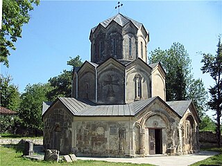
The Katskhi Monastery of Nativity of the Savior , more commonly known as the Katskhi Monastery is a medieval monastery in Georgia, located in the village of Katskhi near the town of Chiatura. It was built at the behest of the Baguashi family in the period of 988–1014. The church building is noted for a hexagonal design and rich ornamentation. Closed down by the Soviet government in 1924, the monastery was revived in 1990 and is now operated by the Eparchy of Sachkhere and Chiatura of the Georgian Orthodox Church.

The Chiatura mine is a large mine complex located near the town of Chiatura in central-western Georgia in the Imereti region west of the national capital Tbilisi.
The 2013–14 Georgian Cup is the seventieth season overall and the twenty-fourth since independence of the Georgian annual football tournament. The competition began on 21 August 2013 and will end with the final in May 2014. The defending champions are Dinamo Tbilisi, after winning their tenth ever Georgian Cup last season. The winner of the competition will qualify for the second qualifying round of the 2014–15 UEFA Europa League.
The 2015–16 Georgian Cup was the nighteen season overall and the twenty-six since independence of the Georgian annual football tournament. The competition began on 17 August 2015 and finished on 18 May 2016.

Skande, sometimes known as Skanda (სკანდა), is a village in the Terjola Municipality, Imereti, Georgia. It is located in western part of the country, in the small river valley of Chkhari, part of the Kvirila River system, some 15 km northeast of the town of Terjola. Its population as of the 2014 census was 434.
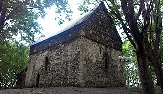
Vartsikhe is a village in the Baghdati Municipality, Imereti, Georgia. It is located in western part of the country, in the Imereti Lowlands, at the confluence of the Rioni and Khanitskali rivers, some 17 km northwest of the town of Baghdati. Its population as of the 2014 census was 1,559.

The Speti church of the Savior is an 11th-century Georgian Orthodox church in the western Georgian region of Imereti. It is a single-nave hall church, its most recognizable feature being a medieval ornate iconostasis made of alabaster and stucco. The church is inscribed on the list of Georgia's Immovable Cultural Monuments of National Significance.

The Mghvimevi monastery is a Georgian Orthodox monastery in the western Georgian region of Imereti, near the town of Chiatura, partly carved into rock. Its main feature is a 13th-century two-nave basilica, dedicated to the Nativity of the Mother of God. The complex also includes a small hall church, bell-tower, and a circuit wall. The monastery is a functioning nunnery. It is rich in ornamental architectural sculpture which decorate the exterior of the churches. The Mghvimevi complex is inscribed on the list of Georgia's Immovable Cultural Monuments of National Significance.
Sakajia Cave Natural Monument is a karst cave located 1.5 km to the north-east from village Godogani, Terjola Municipality in Imereti region of Georgia, 204 meters above sea level. It is located on the left slope of the scenic Tskaltsiteli Gorge across the river from Motsameta monastery, 1.5 km southwest. Many important archaeological, paleobotanical and paleozoic discoveries has been made in the cave.


