Terpes | |
|---|---|
Village (község) | |
 | |
 Coat of arms | |
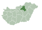
 Location of Heves County in Hungary | |
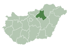
 Terpes Location in Hungary | |
| Coordinates: 47°58′01″N20°09′00″E / 47.96694°N 20.15000°E Coordinates: 47°58′01″N20°09′00″E / 47.96694°N 20.15000°E | |
| Country | |
| Region | Northern Hungary |
| County | Heves County |
| District | Pétervására |
| Government | |
| • Mayor | Zvaráné Béres Mária (Ind.) |
| Area | |
| • Total | 2.2 km2 (0.8 sq mi) |
| Population (2015) | |
| • Total | 212 |
| • Density | 96/km2 (250/sq mi) |
| Time zone | UTC+1 (CET) |
| • Summer (DST) | UTC+2 (CEST) |
| Postal code | 3334 |
| Area code | 36 |
| Website | http://www.terpes.hu/ |
Terpes is a village in Heves County, Hungary. [1]