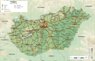
Hungary is a landlocked country in the southeastern region of Central Europe, bordering the Balkans. Situated in the Pannonian Basin, it has a land area of 93,030 square km, measuring about 250 km from north to south and 524 km from east to west. It has 2,106 km of boundaries, shared with Slovakia to the north, Ukraine to the northeast, Romania to the east and southeast, Serbia to the south, Croatia to the south and southwest, Slovenia to the west and southwest, and Austria to the west.

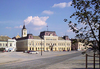
Debrecen is Hungary's second-largest city, after Budapest, the regional centre of the Northern Great Plain region and the seat of Hajdú-Bihar County. A city with county rights, it was the largest Hungarian city in the 18th century and it is one of the Hungarian people's most important cultural centres. Debrecen was also the capital city of Hungary during the revolution in 1848–1849. During the revolution, the dethronement of the Habsburg dynasty was declared in the Reformed Great Church. The city also served as the capital of Hungary by the end of World War II in 1944–1945. It is home to the University of Debrecen.

Satu Mare is a city with a population of 102,400 (2011). It is the capital of Satu Mare County, Romania, as well as the centre of the Satu Mare metropolitan area. It lies in the region of Maramureș, broadly part of Transylvania. Mentioned in the Gesta Hungarorum as castrum Zotmar, the city has a history going back to the Middle Ages. Today, it is an academic, cultural, industrial, and business centre in the Nord-Vest development region.

Odorheiu Secuiesc is the second largest municipality in Harghita County, Transylvania, Romania. In its short form, it is also known as Odorhei in Romanian and Udvarhely in Hungarian. The Hungarian name of the town "Udvarhely" means "courtyard place".

Jibou is a town in Sălaj County, Transylvania, Romania. In 2021 it had a population of 9,677. Jibou includes the town proper and other four villages: Rona, Cuceu (Kucsó), Husia (Hosszúújfalu), and Var (Szamosőrmező).

Eötvös Loránd University is a Hungarian public research university based in Budapest. Founded in 1635, ELTE is one of the largest and most prestigious public higher education institutions in Hungary. The 28,000 students at ELTE are organized into nine faculties, and into research institutes located throughout Budapest and on the scenic banks of the Danube. ELTE is affiliated with 5 Nobel laureates, as well as winners of the Wolf Prize, Fulkerson Prize and Abel Prize, the latest of which was Abel Prize winner László Lovász in 2021.

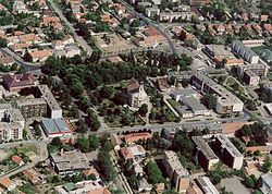
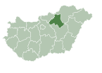
Nyíregyháza is a city with county rights in northeastern Hungary and the county capital of Szabolcs-Szatmár-Bereg. With a population of 118,001, it is the seventh-largest city in Hungary and the second largest in the Northern Great Plain region. Its development has been ongoing since the 18th century, making it the economic and cultural center of the region. Nyíregyháza Zoo, with over 500 species, is recognized throughout Europe.
Baja is a city with county rights in Bács-Kiskun County, southern Hungary. It is the second largest city in the county, after the county seat at Kecskemét, and is home to some 35,000 people. Baja is the seat of the Baja municipality.

Tiszaújváros is an industrial town in Borsod-Abaúj-Zemplén county, Northern Hungary, 35 km (22 mi) south-east of Miskolc, near the river Tisza.

Gyöngyös is a town in Heves County, Hungary, beside of the Gyöngyös creek, under the Mátra mountain ranges. As of 2022 census, it has a population of 27,957. The town located 8.4 km from the M3 motorway and 80.8 km far from Budapest. Gyöngyös is terminus of the Vámosgyörk–Gyöngyös railway line and the main road 3 lead across the town. Gyöngyös have a train station and a stop on the standard gauge railway line and two narrow gauge railways also start from here to the mountains for tourist purposes.

Herend is a small town in Hungary (Europe), near the city of Veszprém.
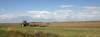
The Great Hungarian Plain is a plain occupying the majority of the modern territory of Hungary. It is the largest part of the wider Pannonian Plain. Its territory significantly shrank due to its eastern and southern boundaries being adjusted by the new political borders created after World War I when the Treaty of Trianon was signed in 1920.

Heves county lies in northern Hungary, between the right bank of the river Tisza and the Mátra and Bükk mountains. It shares borders with the Hungarian counties Pest, Nógrád, Borsod-Abaúj-Zemplén and Jász-Nagykun-Szolnok. Eger is the county seat.
Jász–Nagykun–Szolnok is an administrative county in Hungary. It lies in central Hungary and shares borders with the Hungarian counties Pest, Heves, Borsod–Abaúj–Zemplén, Hajdú–Bihar, Békés, Csongrád, and Bács–Kiskun. The rivers Tisza and Körös flow through the county. The capital of Jász–Nagykun–Szolnok county is Szolnok. Its area is 5582 km2. The county is named after the Ossetians (Jasz) and Cumans (Kun) who settled there, along with Szolnok. The county was part of the Danube–Criș–Mureș–Tisa Euroregion between 1997 and 2004.

Csanádpalota is a town in the Makó-region of Csongrád county, in Hungary's Southern Great Plain.

Bátonyterenye is a town in Nógrád County, Hungary, under the Mátra mountain range, beside of the Zagyva river. As of 2022 census, it has a population of 11,296. The town located beside of the Hatvan–Fiľakovo railway line and the main road 21. The M3 motorway is 42.6 km far. The city has two railway stations: Kisterenye in the north and Nagybátony in the south.
Szolnok County was a county in the Kingdom of Hungary between the 11th century and 1426. It was made up of two disconnected parts, one in what later became Transylvania and the Partium, the other around the Tisza centred on the settlement of Szolnok. The county was eventually split and became:

Mátramindszent is a village in Nógrád County, Hungary, in the Mátra mountain range, the bottom of the north side of the Galya-tető peak, the Mindszenti creek flows through the settlement. As of 2022 census, it has a population of 707. The village is located 2.0 km from Kisterenye–Kál-Kápolna railway line, 11.7 km from the main road 21 and 52.1 km from the M25 expressway. Although the settlement has its own railway station, but public transport on the railway line ceased on 3 March 2007. The closest train station with public transport in Bátonyterenye 11.7 km far.

Gyöngyöspata is a town in Heves County, Hungary, beside of the Danka creek, under the Mátra mountain ranges. As of 2022 census, it has a population of 2338. The village located 9.1 km from Hatvan–Fiľakovo railway line, 10.5 km from the main road 21 and 19.7 km from the M3 motorway. The closest train station with public transport in Szurdokpüspöki.

Gyöngyöstarján is a village in Heves County, Hungary, beside of the Tarján creek, under the Mátra mountain ranges. As of 2022 census, it has a population of 2219. The village located 7.1 km from Vámosgyörk–Gyöngyös railway line, 7.5 km from the main road 3 and 15.0 km from the M3 motorway. The closest train station with public transport in Gyöngyös.