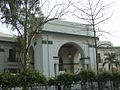
The Mall, also known as Mall Road, is a major thoroughfare in Lahore, Pakistan. Constructed following the Indian Rebellion of 1857, the road serves as the city's primary arterial corridor, linking the historic Walled City in the west to the civil and military lines in the east. It is known for its colonial-era architecture, which evolves from Neoclassical and Neo-Gothic styles in the west to the syncretic Indo-Saracenic style in the east.[1][2]
The development of The Mall began in the area now known as Lower Mall, which pre-dated British administration. Key pre-colonial structures included the Civil Secretariat, originally built as the residence of General Jean-Baptiste Ventura, a French officer in the Sikh Khalsa Army. It was constructed within the garden of the Tomb of Anarkali, a Mughal-era mausoleum. Another major structure was the Sikh Horse Coach building, located near the Walled City; after the British annexation in 1849, this building was incorporated into Government College Lahore to serve as the institution's gymnasium.[1]
Following the 1857 Rebellion, the British established their first cantonment in the Anarkali Bazaar area.[1] However, security concerns regarding a military presence within a densely populated market led to the relocation of the cantonment.[1] According to historical accounts, the new site was selected during a morning ride by the British Commander-in-Chief, Sir Charles Napier, and the colonial administrators Henry and John Lawrence. Napier identified a location five miles east, present-day Abid Majeed Road and Tufail Road, as the site for the Mian Mir Cantonment.[1]
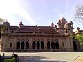
As the road extended eastward toward the new cantonment, the architectural style began to incorporate local elements, resulting in a fusion of Gothic and Oriental designs. This section houses the General Post Office (GPO), the Lahore High Court (formerly the Chief's Court), the Telegraph Office, and the YMCA.[1]
A focal point of The Mall is Charing Cross, named after the junction in London. This intersection was originally dominated by a marble canopy housing a statue of Queen Victoria. Following independence, the statue was removed to the Lahore Museum, and during the regime of General Zia-ul-Haq, it was briefly replaced by a wooden replica of the Quran.[1]
This page is based on this Wikipedia article Text is available under the CC BY-SA 4.0 license; additional terms may apply. Images, videos and audio are available under their respective licenses.