
Bedourie is a town and a locality in the Shire of Diamantina, Queensland, Australia. It is on the border with the Northern Territory. In the 2021 census, the locality of Bedourie had a population of 150 people.
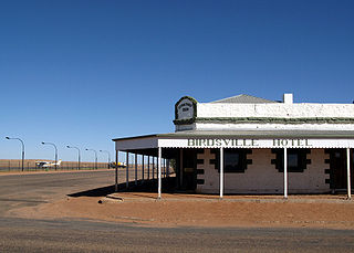
Birdsville is a rural town and locality in the Shire of Diamantina, Queensland, Australia. The locality is on the Queensland border with both the Northern Territory and South Australia. The town is situated 10 kilometres (6 mi) north of the South Australian border. In the 2021 census, the locality of Birdsville had a population of 110 people.

Cloncurry is a rural town and locality in the Shire of Cloncurry, Queensland, Australia. It is informally known by local people as The Curry. In the 2021 census, the locality of Cloncurry had a population of 3,167 people.

Dajarra is a rural town and a locality in the Shire of Cloncurry, Queensland, Australia. In the 2021 census, the locality of Dajarra had a population of 186 people.
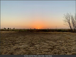
Julia Creek is an outback town and locality in the Shire of Mckinlay, Queensland, Australia. In the 2021 census, the locality of Julia Creek had a population of 549 people.

Landsborough is a town and a locality in the Sunshine Coast Region, Queensland, Australia. In the 2021 census, the locality of Landsborough had a population of 4,446 people.

The Shire of Cloncurry is a local government area in North West Queensland, Australia. It covers an area of 47,971 square kilometres (18,521.7 sq mi), and has existed as a local government entity since 1884. The major town and administrative centre of the shire is Cloncurry.

The Shire of Burke is a local government area in North West Queensland, Australia. The shire lies on the south coast of the Gulf of Carpentaria and abuts the border with the Northern Territory. It covers an area of 39,864 square kilometres (15,391.6 sq mi), and has existed as a local government entity since 1885. The major town and administrative centre of the shire is Burketown.

Inkerman is a rural town and locality in the Shire of Burdekin, Queensland, Australia. In the 2021 census, the locality of Inkerman had a population of 119 people.
Irvinebank is a rural town and locality in the Shire of Mareeba, Queensland, Australia. In the 2021 census, the locality of Irvinebank had a population of 113 people.
Adavale is a rural town and locality in the Shire of Quilpie, Queensland, Australia. In the 2021 census, the locality of Adavale had a population of 72 people.
Dajarra and Selwyn Branch Railways were lines in north-west Queensland, Australia. Along with the Mount Cuthbert and Dobbyn Branch Railways, they were essentially built to tap large deposits of copper discovered in the Cloncurry region.

McKinlay is an outback town and locality in McKinlay Shire, Queensland, Australia. In the 2021 census, the locality of McKinlay had a population of 162 people.

Duchess is a rural town and locality in the Shire of Cloncurry, Queensland, Australia. In the 2021 census, the locality of Duchess had a population of 53 people.
Mount Cuthbert is a former copper mining town in the locality of Three Rivers, Shire of Cloncurry, Queensland, Australia. It is now a ghost town.
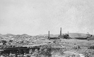
Selwyn is a rural town and locality in the Shire of Cloncurry, Queensland, Australia. Selwyn is now an abandoned mining town. In the 2021 census, the locality of Selwyn had a population of 25 people.

Lawn Hill is an outback locality split between the Shire of Burke and the City of Mount Isa in Queensland, Australia. The locality is on the Queensland border with the Northern Territory. In the 2021 census, Lawn Hill had a population of 63 people.
Kuridala is a rural locality in the Shire of Cloncurry, Queensland, Australia. It contains the former mining town of the same name. In the 2021 census, Kuridala had a population of 38 people.

Four Ways is an outback locality in the Shire of Cloncurry, Queensland, Australia. In the 2021 census, Four Ways had a population of 76 people.
Malbon is a town in the locality of Kuridala in the Shire of Cloncurry, Queensland, Australia.
