
Mount Molloy is a rural town and locality in the Shire of Mareeba, Queensland, Australia. It is a historic mining and timber town, 55 kilometres (34 mi) north of Cairns. The dominant industry in the area is cattle grazing; the town itself consists of a few shops and an old hotel. In the 2021 census, the locality of Mount Molloy had a population of 266 people.
Ballara is the site of a deserted mining town in the locality of Kuridala in north-western Queensland, Australia, in the Selwyn Range between the towns of Mount Isa and Cloncurry. It is within the local government area of Shire of Cloncurry.
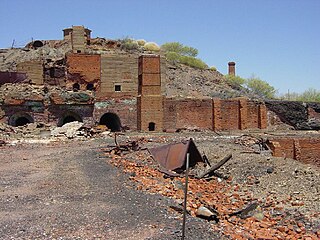
The Chillagoe smelters is a heritage-listed refinery at Chillagoe-Mungana Caves National Park, Mareeba Mining District, Chillagoe, Shire of Mareeba, Queensland, Australia. It operated in the early 1900s. It is also known as Chillagoe State Smelters. It was added to the Queensland Heritage Register on 21 October 1992.
Mount Cuthbert is 100 kilometres north-west of Cloncurry, Queensland. It was once a copper mining town, booming in 1918, when Pugh's Almanac Queensland Directory estimated Mount Cuthbert's population at 750. It recorded six boarding houses, a hotel, a racing club and several stores in the town. Mount Cuthbert's population quickly declined mainly due to the global collapse of the copper market. Mt Cuthbert in the 1921 census had population of only 267 and by 1924 Pugh's notes that most storekeepers had left. The Railway branch line to Mount Cuthbert was closed in 1949.
Dajarra and Selwyn Branch Railways were lines in north-west Queensland, Australia. Along with the Mount Cuthbert and Dobbyn Branch Railways, they were essentially built to tap large deposits of copper discovered in the Cloncurry region.
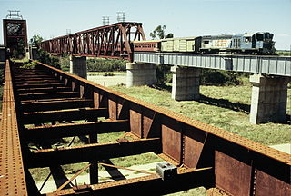
The Great Northern Railway is a 1067 mm gauge railway line in Queensland, Australia. The line stretches nearly 1,000 kilometres linking the port city of Townsville, Australia to the mining town of Mount Isa in north-west Queensland. Along with a passenger service called the Inlander, it is a major freight route connecting the Mount Isa Mines to the Port of Townsville. In 2010, the line moved 5.8 million tonnes of cargo, and this is expected to increase significantly in coming years.
Kajabbi is a rural town in the locality of Three Rivers, Shire of Cloncurry, Queensland, Australia.

Duchess is a rural town and locality in the Shire of Cloncurry, Queensland, Australia. In the 2021 census, the locality of Duchess had a population of 53 people.
Selwyn is a rural town and locality in the Shire of Cloncurry, Queensland, Australia. Selwyn is now an abandoned mining town. In the 2021 census, the locality of Selwyn had a population of 25 people.

Cloncurry Post Office is a heritage-listed post office at 47 Scarr Street, Cloncurry, Shire of Cloncurry, Queensland, Australia. It was designed by Queensland Works Department and built in 1906. It was added to the Queensland Heritage Register on 27 May 2005.
Mount Elliott Company Metallurgical Plant and Mill is a heritage-listed smelting works via Sheaffe Street, Cloncurry, Shire of Cloncurry, Queensland, Australia. It was built from 1926 to April 1927. It was added to the Queensland Heritage Register on 17 June 2003.

Mount Cuthbert Township and Smelter is a heritage-listed mining camp north-west of Kajabbi Township, Three Rivers, Shire of Cloncurry, Queensland, Australia. It was built from c. 1908 to c. 1925. It is also known as Kalkadoon Mine & Winding Plant, Mount Cuthbert Mine & Smelter, and Mount Cuthbert Township & Railway Formation. It was added to the Queensland Heritage Register on 25 May 2004.
Three Rivers is a rural locality in the Shire of Cloncurry, Queensland, Australia. In the 2021 census, Three Rivers had a population of 93 people.
Kuridala is a rural locality in the Shire of Cloncurry, Queensland, Australia. It contains the former mining town of the same name. In the 2021 census, Kuridala had a population of 38 people.

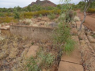
Kuridala Township site is a heritage-listed mining camp in the locality of Kuridala, Shire of Cloncurry, Queensland, Australia. It was built from 1880s to 1920s. It is also known as Hampden Township, Hampden Smelter, Kuridala Smelter, and Friezeland Township. It was added to the Queensland Heritage Register on 12 June 2009.
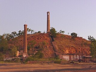
Mount Elliott Mining Complex is a heritage-listed copper mine and smelter at Selwyn, Shire of Cloncurry, Queensland, Australia. It was designed by William Henry Corbould and built in 1908. It is also known as Mount Elliott Smelter and Selwyn. It was added to the Queensland Heritage Register on 16 September 2011.

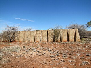
Mount Perry Powder Magazine is a heritage-listed former gunpowder magazine at Sandy Camp Road, Mount Perry, North Burnett Region, Queensland, Australia. It was built in 1874 by Queensland Department of Public Works. It was added to the Queensland Heritage Register on 10 June 2011.

Dobbyn is a ghost town and former copper mine in the locality of Three Rivers, Shire of Cloncurry, Queensland, Australia.
Wee MacGregor railway is a heritage-listed tramway and railway associated with the former towns of Ballara and Hightville in the locality of Kuridala, Shire of Cloncurry, Queensland, Australia. It was built from 1909 to 1926. It was added to the Queensland Heritage Register on 1 March 2019.
Cloncurry–Dajarra Road is a continuous 169 kilometres (105 mi) road route in the Cloncurry local government area of Queensland, Australia. It is a state-controlled district road rated as a local road of regional significance (LRRS). It is a north-east to south-west link between the Barkly Highway and the Diamantina Developmental Road, servicing a number of cattle grazing and production areas in northern Queensland.

