
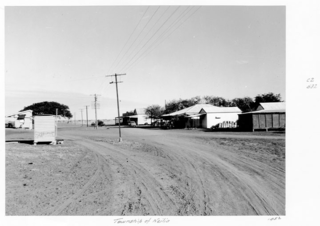
Dobbyn is a ghost town and former copper mine in the locality of Three Rivers, Shire of Cloncurry, Queensland, Australia.. [1]
Dobbyn is a ghost town and former copper mine in the locality of Three Rivers, Shire of Cloncurry, Queensland, Australia.. [1]
It was the railhead for the Mount Cuthbert and Dobbyn railway lines.
Dobbyn State School opened in 1918 and closed circa 1954. [2]

Cloncurry is a rural town and locality in the Shire of Cloncurry, Queensland, Australia. In the 2016 census the locality of Cloncurry had a population of 2,719 people.

Dajarra is a town and a locality in the Shire of Cloncurry, Queensland, Australia. In the 2016 census, Dajarra had a population of 191 people.
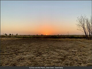
Julia Creek is an outback town and locality in the Shire of Mckinlay, Queensland, Australia. In the 2016 census, the locality of Julia Creek had a population of 511 people.

Richmond is a rural town and locality in the Shire of Richmond, Queensland, Australia. In the 2016 census, the locality of Richmond had a population of 648 people.

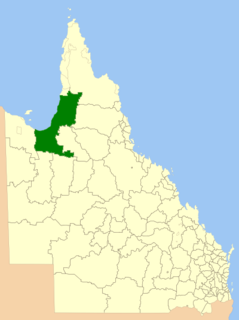
The Shire of Cloncurry is a local government area in North West Queensland, Australia. It covers an area of 47,971 square kilometres (18,521.7 sq mi), and has existed as a local government entity since 1884. The major town and administrative centre of the shire is Cloncurry.

The Shire of Mckinlay is a local government area in outback north-western Queensland, Australia.
The Shire of Carpentaria is a local government area in Far North Queensland, Australia on the Gulf of Carpentaria, for which it is named.
Kynuna is an outback town in the Shire of McKinlay and a locality split between the Shire of McKinlay and the Shire of Winton in Queensland, Australia. In the 2016 census the locality of Kynuna had a population of 55 people.
Mount Cuthbert is 100 kilometres north-west of Cloncurry, Queensland. It was once a copper mining town, booming in 1918, when Pugh's Almanac Queensland Directory estimated Mount Cuthbert's population at 750. It recorded six boarding houses, a hotel, a racing club and several stores in the town. Mount Cuthbert's population quickly declined mainly due to the global collapse of the copper market. Mt Cuthbert in the 1921 census had population of only 267 and by 1924 Pugh's notes that most storekeepers had left. The Railway branch line to Mount Cuthbert was closed in 1949.
Dajarra and Selwyn Branch Railways were lines in north-west Queensland, Australia. Along with the Mount Cuthbert and Dobbyn Branch Railways, they were essentially built to tap large deposits of copper discovered in the Cloncurry region.
Kajabbi is a rural town in the locality of Three Rivers, Shire of Cloncurry, Queensland, Australia.
Duchess is a rural town and locality in the Shire of Cloncurry, Queensland, Australia. In the 2016 census, Duchess had a population of 23 people.
Nelia is an outback town in the locality of Julia Creek in the Shire of Mckinlay, Queensland, Australia.
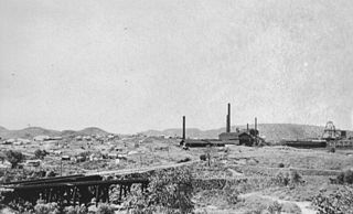
Mount Cuthbert is a former copper mining town in the locality of Three Rivers, Shire of Cloncurry, Queensland, Australia. It is now a ghost town.
Selwyn is a rural town and locality in the Shire of Cloncurry, Queensland, Australia. Selwyn is now an abandoned mining town. In the 2016 census the locality of Selwyn had a population of 50 people.
Three Rivers is a rural locality in the Shire of Cloncurry, Queensland, Australia. In the 2016 census Three Rivers had a population of 27 people.
Kuridala is a former mining township and locality in the Shire of Cloncurry, Queensland, Australia. In the 2016 census the locality of Kuridala had a population of 10 people.
Malbon is a town in the locality of Kuridala in the Shire of Cloncurry, Queensland, Australia.
The Monument is a mining town in the Shire of Cloncurry, Queensland, Australia. It is nicknamed Phosphate Hill.
Cloncurry–Dajarra Road is a continuous 169 kilometres (105 mi) road route in the Cloncurry local government area of Queensland, Australia. It is a state-controlled district road rated as a local road of regional significance (LRRS). It is a north-east to south-west link between the Barkly Highway and the Diamantina Developmental Road, servicing a number of cattle grazing and production areas in northern Queensland.