
Kallang is a planning area and residential zone located in the Central Region of Singapore.
Bugis MRT station is an underground Mass Rapid Transit (MRT) interchange station on the East–West (EWL) and Downtown (DTL) lines. Situated in Bugis, Singapore, the station is underneath the junction of Rochor Road and Victoria Street. Various developments surrounding the station include Bugis Junction, Raffles Hospital and the National Library. The station is also close to Kampung Glam.
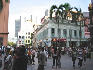
Bugis is an area in Singapore that covers Bugis Street, now located within the Bugis Junction shopping mall. Bugis Street was renowned internationally from the 1950s to the 1980s for its nightly gathering of transvestites and transsexuals, a phenomenon which made it one of Singapore's most notable attractions for foreign visitors at the time.
Victoria Street is a major two-way road in Singapore. It links Kallang Road in the northeast with Hill Street in the southwest. En route, Victoria Street passes through the planning areas of Kallang, Rochor, Downtown Core and Museum.

North Bridge Road is a one-way road in Singapore, running north of the Singapore River. It starts at the junction with Crawford Street in Kallang, on the western bank of the Rochor River, and continues in a southwest direction before ending at Elgin Bridge. The stretch south of the Singapore River after Elgin Bridge is called South Bridge Road. En route, North Bridge Road travels through the planning areas of Kallang, Rochor and the Downtown Core.

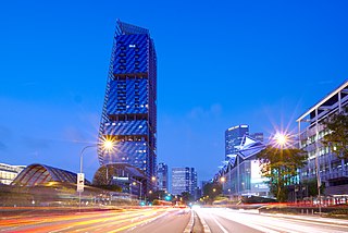
This article shows the notable future developments in Singapore. Most of them are currently under construction with most to be completed within the next five years.

Waterloo Street is a two-way street in downtown Singapore stretching from Rochor Road to Bras Basah Road. It passes through the planning areas of Rochor and Museum Planning Area.

Middle Road is a road in the Central Area of Singapore, stretching along the Downtown Core and Rochor planning areas. It starts from its junction with Selegie Road and ends at its junction with Nicoll Highway. Middle Road was already in existence in early Singapore, appearing in George Drumgoole Coleman's Map of Singapore in 1836. The area around Middle Road was the original settlement of the Hainanese immigrant community, a community noted for its active role in the food and beverage history of Singapore. From the late 19th century until the Second World War, the area around Middle Road, Hylam Street and Malay Street was also a bustling Japanese enclave known for its brothels of Karayuki-san and traditional shops run by the Japanese immigrants.
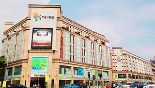
The Verge, formerly Tekka Mall, was the first and largest modern shopping mall at the Little India precinct in Singapore, being opened in 2003. The Verge had two buildings, the main building and Chill @ The Verge. It was located on the southern part of Little India, with the main building is located at the junction of Serangoon Road and Sungei Road and the Chill @ The Verge is located at the junction of Perak Road and Sungei Road. Both of the buildings were separated by Clive Street and the mall lies opposite of Tekka Centre across Serangoon Road. The complex was demolished in 2017 to make way for redevelopment after 14 years of operation, making it one of the youngest malls in Singapore to shut its doors.

The DHL Balloon, in Singapore, was the world's second largest tethered helium balloon. It was inflated in 2006, and closed and dismantled in October 2008.
South Beach is a commercial and residential complex located on Beach Road in the Downtown Core of Singapore. It is composed of a hotel tower managed by JW Marriott Hotels, an office tower, shops and residences. The project includes the restoration of four conservation buildings – the former Non-Commissioned Officers' Club building and part of the former Beach Road Camp. It is accessible from Esplanade MRT station.
DUO is a contemporary twin-tower integrated mixed-use development in Singapore, comprising residential accommodation, offices, a hotel and a retail gallery.

Rochor MRT station is an underground Mass Rapid Transit (MRT) station on the Downtown Line (DTL) in Rochor, Singapore. Located between Sungei Road and Rochor Canal Road, the station serves landmarks such as Sim Lim Square, The Verge, the LASALLE College of the Arts and Tekka Centre. The station is operated by SBS Transit.

Kallang Riverside Park is a riverine park in Kallang, Singapore. It sits on the confluence of the Kallang River and Rochor River, north of the Kallang Basin.

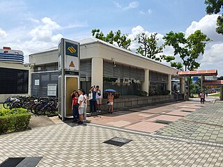
Jalan Besar MRT station is an underground Mass Rapid Transit station on the Downtown Line in Rochor, Singapore. The station is located under Jalan Besar, at the junction with Weld Road, hence its name.

Millenia Singapore is an integrated landmark development of Pontiac Land Group, nested in the Downtown Core of Singapore. It sits on land reclaimed in the 1970s from Marina Bay with five buildings designed by award-winning architects Kevin Roche, Thom Mayne, Philip Johnson and John Burgee.

Kampong Bugis is a subzone within the planning area of Kallang, Singapore, as defined by the Urban Redevelopment Authority (URA). This subzone is bounded by Kallang Road and Sims Avenue in the north; the Kallang–Paya Lebar Expressway (KPE) and Sims Way in the east; Nicoll Highway in the south; and Crawford Street in the west.

Crawford is a subzone within the planning area of Kallang, Singapore, as defined by the Urban Redevelopment Authority (URA). Its perimeter is made up of Rochor River and Rochor Canal in the north; Crawford Street, Nicoll Highway, Kallang Basin and Marina Channel in the east; East Coast Parkway (ECP) in the south; as well as Ophir Road, Beach Road and Jalan Sultan in the west.

Shaw Tower, also sometimes referred to as Shaw Towers, is a defunct high-rise commercial building located on Beach Road in Singapore. At the time of its completion in 1975, the tower housed the largest cinema in Singapore.
Selegie House is a public housing complex which includes blocks 8-10 along Selegie Road in Singapore.

