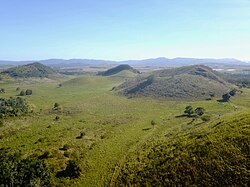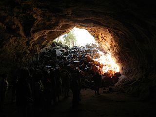
The Undara Volcanic National Park is a national park in the Shire of Etheridge, Queensland, Australia. It is situated 275 kilometres southwest of Cairns just off the Gulf Developmental Road. The park was established in 2009 to protect Australia's longest lava tube and the unique fauna and flora found of the area. The basalts of the area form part of the Cenozoic McBride Basalt (Volcanic) Provence. The volcanics are all less than 8 million years old (Ma) with the youngest only 7,000 years old.
The Curtain Fig National Park is a national park on the Atherton Tableland in Far North Queensland, Australia. The National Park is located near Yungaburra. Its most valued features are its once regionally common, now endangered Mabi forests including a huge strangler fig which attracts up to 100 000 visitors per year, locally known as the Curtain Fig Tree, plus a near threatened, locally endemic tree-kangaroo species i.e. the Lumholtz's tree-kangaroo which finds refuge inside this protected area
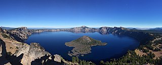
Crater Lake National Park is an American national park located in southern Oregon. Established in 1902, Crater Lake is the fifth-oldest national park in the United States and the only national park in Oregon. The park encompasses the caldera of Crater Lake, a remnant of Mount Mazama, a destroyed volcano, and the surrounding hills and forests.

Whakaari / White Island, also known as White Island or Whakaari, is an active andesite stratovolcano situated 48 km (30 mi) from the east coast of the North Island of New Zealand, in the Bay of Plenty. The island covers an area of approximately 325 ha, which is just the peak of a much larger submarine volcano.

Yungaburra is a rural town and locality in the Tablelands Region, Queensland, Australia. In the 2021 census, the locality of Yungaburra had a population of 1,272 people.

Mount Thielsen, is an extinct shield volcano in the Oregon High Cascades, near Mount Bailey. Because eruptive activity ceased 250,000 years ago, glaciers have heavily eroded the volcano's structure, creating precipitous slopes and a horn-like peak. The spire-like shape of Thielsen attracts lightning strikes and creates fulgurite, an unusual mineral. The prominent horn forms a centerpiece for the Mount Thielsen Wilderness, a reserve for recreational activities such as skiing and hiking. Thielsen is one of Oregon's Matterhorns.
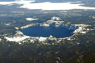
Mount Mazama is a complex volcano in the western U.S. state of Oregon, in a segment of the Cascade Volcanic Arc and Cascade Range. A volcanic peak once existed, but it collapsed following a major eruption approximately 7,700 years ago, to be replaced by a caldera. The volcano is in Klamath County, in the southern Cascades, 60 miles (97 km) north of the Oregon–California border. Its collapse, due to the eruption of magma emptying the underlying magma chamber, formed a caldera that holds Crater Lake. Mount Mazama originally had an elevation of 12,000 feet (3,700 m), but following its climactic eruption this was reduced to 8,157 feet (2,486 m). Crater Lake is 1,943 feet (592 m) deep, the deepest freshwater body in the U.S. and the second deepest in North America after Great Slave Lake in Canada.

Mount Washington is a deeply eroded volcano in the Cascade Range of Oregon. It lies within Deschutes and Linn counties and is surrounded by the Mount Washington Wilderness area.

Belknap Crater is a shield volcano in the Cascade Range in the U.S. state of Oregon. Located in Linn County, it is associated with lava fields and numerous subfeatures including the Little Belknap and South Belknap volcanic cones. It lies north of McKenzie Pass and forms part of the Mount Washington Wilderness. Belknap is not forested and most of its lava flows are not vegetated, though there is some wildlife in the area around the volcano, as well as a number of tree molds formed by its eruptive activity.

The Atherton Tableland is a fertile plateau, which is part of the Great Dividing Range in Queensland, Australia. It has very deep, rich basaltic soils and the main industry is agriculture. The principal river flowing across the plateau is the Barron River, which was dammed to form the irrigation reservoir named Lake Tinaroo. Unlike many other rural areas, the Tablelands is experiencing a significant growth in population.
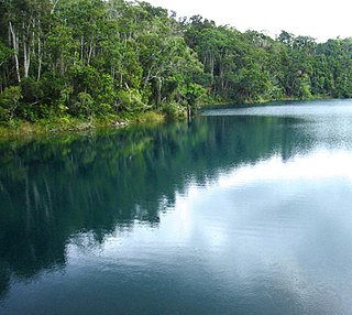
Lake Eacham is a popular lake of volcanic origin on the Atherton Tableland of Queensland, Australia, within the World Heritage listed Wet Tropics of Queensland. It is within the locality of Lake Eacham in the Tablelands Region local government area.

Broken Top is a glacially eroded complex stratovolcano. It lies in the Cascade Volcanic Arc, part of the extensive Cascade Range in the U.S. state of Oregon. Located southeast of the Three Sisters peaks, the volcano, residing within the Three Sisters Wilderness, is 20 miles (32 km) west of Bend, Oregon in Deschutes County. Eruptive activity stopped roughly 100,000 years ago, and erosion by glaciers has since reduced the volcano's cone to where its contents are exposed. There are two named glaciers on the peak, Bend and Crook Glacier.
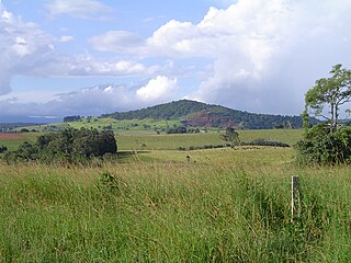
Mount Quincan is a volcanic mountain near Yungaburra on the Atherton Tableland in Far North Queensland, Australia.

Mount Tendürek is a shield volcano on the border of Ağrı and Van provinces in eastern Turkey, near the border with Iran. The volcano, which is mostly known for being near the supposed wreck site of Noah's Ark, is very large; its lava flows cover roughly 650 km2 (251 sq mi) across a swath of flat land. The mountain's two main features are the main summit crater Greater Tendürek, and a smaller crater known as Lesser Tendürek which lies to the east of the main crater. The slopes are very gentle and resemble a shield, after which the type is named. Mount Tendürek is known to have erupted viscous lava like that of volcanoes on the island of Hawaii.

West Crater is a small lava dome with associated lava flows in southern Washington, United States. Located in Skamania County, it rises to an elevation of 4,131 feet (1,259 m), and forms part of the Cascade Volcanic Arc. It is also part of the Marble Mountain-Trout Creek Hill volcanic field, a little-known Quaternary volcanic field in the southern Cascades of Washington state. The area can be hiked, and can be accessed by roads in the Gifford Pinchot National Forest.

Black Crater is a shield volcano in the Western Cascades in Deschutes County, Oregon. Located near McKenzie Pass, the volcano has a broad conical shape with gentle slopes. The volcano likely formed during the Pleistocene and has not been active within the last 50,000 years. Eruptive activity at the volcano produced mafic lava flows made of basaltic andesite and olivine basalt; it also formed a number of cinder cones. A normal fault occurs on the western side of the volcano, trending north–south. The volcano has been eroded by glaciers, which carved a large cirque into the northeastern flank of the mountain, forming its current crater.

Blue Lake Crater is a maar, or a broad, low-relief volcanic crater, in the U.S. state of Oregon. Located in Jefferson County, it consists of three overlapping craters, which hold Blue Lake. The drainage basin for Blue Lake has very steep, forested slopes and is mostly part of the explosion crater left by the volcano's eruption. The volcano lies within the Metolius River basin, which supports a wide array of plant life, large and small mammals, and more than 80 bird species. A 2009 Oregon law designated the Metolius River basin as an area of critical concern, preventing large-scale development and protecting wildlife.
Trout Creek Hill is a small Pleistocene basaltic shield volcano in Washington, United States. Located in Skamania County, Trout Creek Hill rises to an elevation of 2,946 feet (898 m). It is part of the Cascade Volcanic Arc, located in the Marble Mountain-Trout Creek Hill volcanic field.

Aden Crater is a small shield volcano located in Doña Ana County, about 25 miles (40 km) southwest of Las Cruces, New Mexico. It is located in the northwest part of the Aden-Afton basalt field, which is part of the central area of the Potrillo volcanic field.
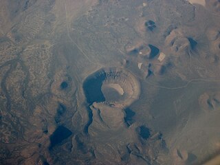
Lunar Crater volcanic field is a volcanic field in Nye County, Nevada. It lies along the Reveille and Pancake Ranges and consists of over 200 vents, mostly small volcanic cones with associated lava flows but also several maars, including one maar named Lunar Crater. Some vents have been eroded so heavily that the structures underneath the volcanoes have been exposed. Lunar Crater itself has been used as a testing ground for Mars rovers and as training ground for astronauts.
