Related Research Articles

The National Highway is a system of roads connecting all mainland states and territories of Australia, and is the major network of highways and motorways connecting Australia's capital cities and major regional centres.

Highways in Australia are generally high capacity roads managed by state and territory government agencies, though Australia's federal government contributes funding for important links between capital cities and major regional centres. Prior to European settlement, the earliest needs for trade and travel were met by narrow bush tracks, used by tribes of Indigenous Australians. The formal construction of roads began in 1788, after the founding of the colony of New South Wales, and a network of three major roads across the colony emerged by the 1820s. Similar road networks were established in the other colonies of Australia. Road construction programs in the early 19th century were generally underfunded, as they were dependent on government budgets, loans, and tolls; while there was a huge increase in road usage, due to the Australian gold rushes. Local government authorities, often known as Road Boards, were therefore established to be primarily responsible for funding and undertaking road construction and maintenance. The early 1900s saw both the increasingly widespread use of motorised transportation, and the creation of state road authorities in each state, between 1913 and 1926. These authorities managed each state's road network, with the main arterial roads controlled and maintained by the state, and other roads remaining the responsibility of local governments. The federal government became involved in road funding in the 1920s, distributing funding to the states. The depression of the 1930s slowed the funding and development of the major road network until the onset on World War II. Supply roads leading to the north of the country were considered vital, resulting in the construction of Barkly, Stuart, and Eyre Highways.

Cobar is a town in central western New South Wales, Australia whose economy is based mainly upon base metals and gold mining. The town is 712 km (442 mi) by road northwest of the state capital, Sydney. It is at the crossroads of the Kidman Way and Barrier Highway. The town and the local government area, the Cobar Shire, are on the eastern edge of the outback. At the 2016 census, the town of Cobar had a population of 3,990. The Shire has a population of approximately 4,700 and an area of 44,065 square kilometres (17,014 sq mi).
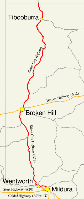
Silver City Highway is a 683-kilometre-long (424 mi) highway that links Buronga, New South Wales to the Queensland border via Wentworth, Broken Hill, and Tibooburra, in the arid Far West region of New South Wales; a short branch also connects to Calder Highway on the Victorian border at Curlwaa. The namesake of the highway is derived from the moniker for Broken Hill – the "Silver City" – which the highway travels through. The highway is designated route B79 from Broken Hill to Buronga.

Sturt Highway is an Australian national highway in New South Wales, Victoria, and South Australia. It is an important road link for the transport of passengers and freight between Sydney and Adelaide and the regions along the route.

Barrier Highway is a highway in South Australia and New South Wales, and is designated part of route A32. The name of the highway is derived from the Barrier Ranges, an area of moderately high ground in the far west of New South Wales, through which the highway traverses.

Cobb Highway is a state highway in the western Riverina and the far western regions of New South Wales, with a short section in Victoria, Australia, designated part of route B75.

Mid-Western Highway, sometimes Mid Western Highway, is a 518-kilometre (322 mi) state highway located in the central western and northern Riverina regions of New South Wales, Australia. The highway services rural communities and links the Great Western, Mitchell, Olympic, Newell, Cobb and Sturt highways. Mid-Western Highway forms part of the most direct route road link between Sydney and Adelaide, with its eastern terminus in Bathurst and western terminus in Hay. It is designated part of route A41 between Bathurst and Cowra, and route B64 between Cowra and Hay.

The Riverina is an agricultural region of southwestern New South Wales, Australia. The Riverina is distinguished from other Australian regions by the combination of flat plains, warm to hot climate and an ample supply of water for irrigation. This combination has allowed the Riverina to develop into one of the most productive and agriculturally diverse areas of Australia. Bordered on the south by the state of Victoria and on the east by the Great Dividing Range, the Riverina covers those areas of New South Wales in the Murray and Murrumbidgee drainage zones to their confluence in the west.

Kidman Way is a state rural road in the western Riverina and western region of New South Wales, Australia. The 643-kilometre (400 mi) highway services the Murrumbidgee Irrigation Area and outback communities and links the Newell Highway with the Sturt, Mid-Western, Barrier, Mitchell and Kamilaroi highways. The road is designated route B87 for its entire length, with its northern terminus at Bourke and its southern terminus just north of Jerilderie. Kidman Way is fully sealed and is accessible by two or four-wheel drive.

Irrigation Way is a major rural road that runs approximately 85 kilometres (53 mi) through the Murrumbidgee Irrigation Area in south western New South Wales, Australia.

Ivanhoe is a very small township on the Cobb Highway between the Lachlan and Darling rivers in New South Wales, Australia. It is located within the Central Darling Shire local government area. Ivanhoe functions as a service centre for the surrounding area. The township is characterised by a particularly wide main street. At the 2021 census, Ivanhoe had a population of 162.

Bylong Valley Way is a New South Wales regional road linking Golden Highway near Sandy Hollow to Castlereagh Highway near Ilford. It is named after the Bylong Valley, through which the road passes.
Mossgiel is a location in New South Wales, Australia, in Carrathool Shire. It was a township on the coach route between the Lachlan and Darling Rivers, 50 km southeast of Ivanhoe near the junction with the road to Hillston. The settlement experienced a steady decline during the 20th century. Nowadays Mossgiel township consists of one house and a community hall.

Lachlan Valley Way is a New South Wales country road running from Booligal to north of Yass. It was named after the Lachlan River, and follows its southern bank for the majority of its length.
Transport in South Australia is provided by a mix of road, rail, sea and air transport. The capital city of Adelaide is the centre to transport in the state. With its population of 1.4 million people, it has the majority of the state's 1.7 million inhabitants. Adelaide has the state's major airport and sea port.

The Central Arnhem Road, also referred to as the Central Arnhem Highway or locally as "The Track", is a designated state route in the Northern Territory of Australia linking the Stuart Highway to the town of Nhulunbuy on the Gove Peninsula and communities across the East Arnhem region. It connects over 12,000 residents and is a key tourism drive and freight route for the mining and pastoral industries.

Gilgunnia is a locality and ghost town in the Orana region of New South Wales, Australia, within the Parish of South Peak in Blaxland County and Cobar Shire. It was once a settlement associated with gold mining, but in 2016 its population was zero. The nearest settlements are Mount Hope and Nymagee.
Clermont–Alpha Road is a continuous 178 kilometres (111 mi) road route in the Isaac and Barcaldine regions of Queensland, Australia. It is signed as State Route 41 for its entire length. It is a state-controlled regional road, rated as a local road of regional significance (LRRS). It is part of the shortest route from Mackay to Longreach.

Wrightville was a mining village in the Orana region of New South Wales, Australia. Once it was a significant settlement, with its own municipal government, public school, convent school, post office, police station, four hotels, and railway connection. At its peak, around 1907, its population probably reached 2,000 people. Its site and that of the adjacent former village of Dapville are now an uninhabited part of Cobar.
References
- 1 2 "The Wool Track". Google Maps.
- ↑ "WOOL TRACK FUNDING STILL ON AGENDA". www.centraldarling.nsw.gov.au. Retrieved 8 December 2023.
- ↑ "Funding to seal 40km of The Wool Track – The Cobar Weekly". cobarweekly.com.au. 22 February 2023. Retrieved 8 December 2023.
- ↑ "'Wool Track' sealing 'feasible'". ABC News. 4 May 2009. Retrieved 8 December 2023.
- ↑ "On the wool track / by C. E. W. Bean; illustrated with photographs by George Bell - Catalogue | National Library of Australia". catalogue.nla.gov.au. Retrieved 8 December 2023.
- ↑ "New Books". Hillston Spectator and Lachlan River Advertiser. 14 January 1926. p. 9. Retrieved 8 December 2023.
- ↑ "George Bell :: biography at :: at Design and Art Australia Online". www.daao.org.au. Retrieved 22 December 2023.
- ↑ Grattan, Michelle (2004). Back on the Wool Track. Random House Australia. ISBN 9781740511674.