
Varkala, also known as The Pearl of the Arabian Sea, is a municipality in the Thiruvananthapuram district, situated in the Indian state of Kerala. Varkala is home to 3% of the total urban population and most densely populated municipality of the district. It is the headquarters of Varkala Taluk and one among the oldest municipalities of Kerala established in 1980. It is the second largest coastal city in the district after the state capital and northern suburb of Trivandrum City. It is located 36 kilometres north of Trivandrum, which is the capital and largest metropolitan city of Kerala and 28 km south of Kollam City.

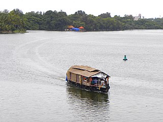
The Kerala backwaters are a network of brackish lagoons and lakes lying parallel to the Arabian Sea coast of Kerala state in southern India, as well as interconnected canals, rivers, and inlets, a labyrinthine system formed by more than 900 kilometres (560 mi) of waterways, and sometimes compared to American bayous. The network includes five large lakes linked by canals, both man made and natural, fed by 38 rivers, and extending virtually half the length of Kerala state. The backwaters were formed by the action of waves and shore currents creating low barrier islands across the mouths of the many rivers flowing down from the Western Ghats range. In the midst of this landscape there are a number of towns and cities, which serve as the starting and end points of backwater cruises.

Conolly Canal, sometimes spelled as Canoly Canal, is the part of the West coast canal (WCC) network of Kerala and the canal was constructed by combining the rivers and streams along the coast with the intention of creating a vast waterway from Kozhikode to Kochi. It was constructed in the year 1848 under the orders of then collector of Malabar, H.V. Conolly initially to facilitate movement of goods to Kallayi Port from hinter lands of Malabar through Kuttiyadi and Korapuzha river systems.

Paravur Kayal is a lake in Paravur, Kollam district, Kerala, India. Although it is small, with an area of only 6.62 km², it is the end point of the Ithikkara River and part of the system of lakes and canals that make up the Kerala Backwaters. It has been connected to Edava and Ashtamudi Kayal as part of the Trivandrum - Shoranur canal system since the late 19th century.

Kundara is a census town in Kerala and is part of the Kollam Metropolitan Area, India. Kundara is situated 13 km east of Kollam city, 14 km west of Kottarakkara, and 24 km north of Paravur. Kundara is significant for its historic involvement in the Indian independence movement.
Devaswom are socio-religious trusts in India that comprise members nominated by both government and community. Their aim is to manage Hindu temples and their assets and to ensure their smooth operation in accordance with traditional rituals and customs. The devaswom system notably exists in the state of Kerala, where most temples are either managed by Government of Kerala-controlled devaswoms or formed by private bodies/families. The properties of each temple are deemed to be the personal property of the presiding deity the temple and are managed through a body of trustees who bear allegiance to the presiding deity.

Edava is a village in Varkala Taluk and one of the 5 panchayats that forms the city of Varkala in Thiruvananthapuram district in the state of Kerala, India. Edava is located 5km North of Varkala city centre, 5km from Varkala Beach and 49km north-west of state capital city Trivandrum. Kappil located in Edava Panchayat is one the major tourist destination in Kerala.

The West Coast Canal or National Waterway No 3 is a 205-km stretch of this inland navigational route located in Kerala, India and runs from Kollam to Kottapuram and was declared a National Waterway in 1993. In addition to the main stretch, Champakara and Udyogmandal canals are navigable and connect the industrial centers of Kochi to Kochi port Inland Waterways Authority of India (IWAI) under the Ministry of Shipping is coordinating the task for developing, monitoring and administering national waterways. It is the first National Waterway in the country with 24-hour navigation facilities along the entire stretch. It has been extended to Kozhikode as per National Waterways Act, 2016. The National Waterway 3 is passing mainly through the alignment of erstwhile Thiruvananthapuram–Shoranur canal.

The following outline is provided as an overview of and topical guide to Kerala:
Thekkumbhagam or Thekkumbhagom is the southern border town of Paravur municipality in the Kollam district of Kerala, India. It is located at the Southern tip of Kollam's coastal area. It is in the Arabian Sea coast. Thekkumbhagam-Kappil estuary point in the Kollam-Thiruvananthapuram coastal border is one of the emerging tourism spots in the state. On 1936, during formation, Thekkumbhagam was one of the 9 territories of Paravur Panchayath. Thekkumbhagam estuary is one among the twin estuary points in Paravur. The other one is Pozhikara estuary.
Thevally is located in the city of Kollam, in the state of Kerala, India. Ashtamudi Lake is situated in the vicinity. National Highway-183 passes through the neighbourhood.

Munroturuttu railway station or Mundrothuruthu railway station(Code:MQO) is an 'HG 2 Category' halt railway station, situated between Perinad and Sasthamkotta railway stations of Kollam district in Kerala state, India. The station is coming under the Southern Railway zone of Indian Railways. The nearest major rail head of Munrothuruthu railway station is Kollam Junction railway station.

Kollam KSWTD Boat Jetty or Kollam KSWTD Ferry Station is an transport hub in the city of Kollam in Kerala, India, one of 14 ferry stations owned by the Kerala State Water Transport Department.

The Paravur Estuaries are a group of estuaries in Paravur, India, near the South-Western coast of Kollam district, Kerala. Paravur is one among the 4 municipal towns in Kollam district, Kerala state. The place is known for its natural beauties, backwater locations, white-sand beaches and concentration of temples.

Kollam Canal or Quilon Canal or Kollam Thodu is a 7.7 km long canal system passing through the city of Kollam, India. It is a part of National Waterway-3 and 78 km long Kollam-Trivandrum (Kovalam) State waterway project.
The Anantha-Victoria-Marthandam Canal a.k.a. A.V.M. Canal was conceived as a 'water link' between Thiruvananthapuram and Kanyakumari in July 1860 during the reign of Uthradam Thirunal Marthanda Varma Maharaja of Travancore state. Today it is the National Waterway 13 of India.

The Ernakulam–Kottayam–Kayamkulam line is a railway line which runs through the districts of Ernakulam, Kottayam, Pathanamthitta and Alappuzha in Kerala state of India. This railway line starts as a branch line from Ernakulam Town railway station towards Kottayam and joins with the Ernakulam–Kayamkulam coastal line route via Alappuzha at Kayamkulam Junction. This line comes under the Thiruvananthapuram railway division of Southern Railway Zone of Indian Railways. The line has a total distance of 118 km (73 mi). The Ernakulam Town/Ernakulam Junction - Kottayam section opened in 1956-57 and Kottayam - Kollam section in 1957.
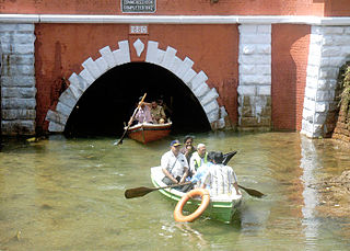
Varkala Tunnel System, situated in municipality of Varkala of Trivandrum, Kerala, India, also known as the Varkala Canal or Varkala Thurapp in local dialect. It is one of the historic sites and architectural marvel of the region. This site was constructed by the Travancore Kingdom to establish a continuous inland waterway across Thiruvithamkoor as TS Canal, which was meant to serve as a trade route. The construction of the two long tunnels was started in 1867 and the first was completed in 1877 while the second was completed in 1880.
Waterways have always been an important mode of transport in Kerala. The total length of navigable route in Kerala was 1,900 kilometres and the navigable rivers constitute about 54 per cent of the waterways. The 41 West-flowing rivers together with the backwaters are an integrated part of the inland navigation system in Kerala. In Kerala water transportation through these channels are mainly small distant passenger services, informal country boats,freight transportation to PSU's such as Fertilisers and Chemicals Travancore, Kochi etc.

